Wagin is a town and shire in the Wheatbelt region of Western Australia, approximately 225 km (139.81 mi) south-east of Perth on the Great Southern Highway between Narrogin and Katanning. It is also on State Route 107. The main industries are wheat and sheep farming.

Corrigin is a town in the central Wheatbelt region of Western Australia, 229 kilometres (142 mi) east-southeast of the state capital, Perth, Western Australia, along State Route 40. It is mostly a farming community focused on crops and sheep, and holds the world record of "the most dogs in a ute".

Kalannie is a small town in the Shire of Dalwallinu, in the Wheatbelt region of Western Australia, approximately 259 kilometres (161 mi) north-east of the state capital, Perth.

Coorow is a town in the Mid West region of Western Australia, 264 kilometres (164 mi) north of Perth.

Tammin is a town in the central agricultural region of Western Australia, 184 kilometres (114 mi) east of Perth and midway between the towns of Cunderdin and Kellerberrin on the Great Eastern Highway.

Moorine Rock is located in the eastern agricultural region of Western Australia, 347 km east of Perth and 22 km west south west of Southern Cross.

Meckering is a town 130 kilometres (80.8 mi) east of Perth, Western Australia along the Great Eastern Highway. Meckering is located within the Shire of Cunderdin.

Bruce Rock is a town in the eastern Wheatbelt region of Western Australia, approximately 243 kilometres (151 mi) east of Perth and 48 kilometres (30 mi) southwest of Merredin. It is the main town in the Shire of Bruce Rock.

Mukinbudin is a small town in the north eastern Wheatbelt region of Western Australia, approximately 298 kilometres (185 mi) east of Perth and 80 kilometres (50 mi) north of Merredin near Lake Campion. It is the main town in the Shire of Mukinbudin. At the 2021 Australian census, Mukinbudin had a population of 336.

Carnamah is a town in the Mid West region of Western Australia, about 307 kilometres (191 mi) north of Perth along the Midlands Road. According to 2021 census, the population of the town is 407.

Pingelly is a town and shire located in the Wheatbelt region of Western Australia, 158 kilometres (98 mi) from Perth via the Brookton Highway and Great Southern Highway. The town is also located on the Great Southern railway line.

The Shire of Cuballing is a local government area in the Wheatbelt region of Western Australia. Cuballing is located 15.1 kilometres (9 mi) north of the town of Narrogin and 192 kilometres (119 mi) southeast of the capital, Perth. The Shire covers an area of 1,195 square kilometres (461 sq mi) and its seat of government is the small town of Cuballing.

Trayning is a town in the north-eastern Wheatbelt region of Western Australia, 236 kilometres (147 mi) east of the state capital, Perth, on the Nungarin–Wyalkatchem Road. At the 2006 census, Trayning had a population of 122.

Nungarin is a town located in the north east of the Wheatbelt region of Western Australia, approximately 278 kilometres (173 mi) east of Perth and 39 kilometres (24 mi) north of Merredin. It is the main town in the Shire of Nungarin. At the 2006 census, Nungarin had a population of 142.

Koorda is a town in the north eastern Wheatbelt region of Western Australia, approximately 236 kilometres (147 mi) east of Perth and 43 kilometres (27 mi) north of Wyalkatchem at the northeastern end of the Cowcowing Lakes. It is the main town in the Shire of Koorda. At the 2016 census Koorda had a population of 414. The surrounding areas produce wheat and other cereal crops. The town is a receival site for Cooperative Bulk Handling.
Yuna is a small town in the Mid West region of Western Australia, in the Shire of Chapman Valley, 62 kilometres (39 mi) northeast of the city of Geraldton.

Kununoppin is a small town in the Wheatbelt region of Western Australia. The town is located on the Nungarin–Wyalkatchem Road and in the Shire of Trayning local government area, 257 kilometres (160 mi) north east of the state capital, Perth, Western Australia. At the 2006 census, Kununoppin had a population of 151.
Welbungin is a small town located just off the Koorda–Southern Cross road 287 km (178 mi) from Perth in the Wheatbelt region of Western Australia.

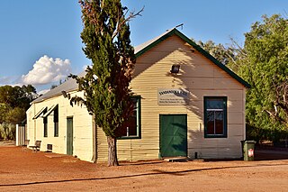
Yandanooka is a small town in the Mid West region of Western Australia. The town is located between Mingenew and Three Springs on the Midlands Road.
Muntadgin is a townsite off the Great Eastern Highway on Brissenden Road, situated between the towns of Bruce Rock and Southern Cross in the Wheatbelt region of Western Australia. At the 2016 census, Muntadgin had a population of 51.


