
Toodyay, known as Newcastle between 1860 and 1910, is a town on the Avon River in the Wheatbelt region of Western Australia, 85 kilometres (53 mi) north-east of Perth. The first European settlement occurred in the area in 1836. After flooding in the 1850s, the townsite was moved to its current location in the 1860s. It is connected by railway and road to Perth. During the 1860s, it was home to bushranger Moondyne Joe.

The Wheatbelt is one of nine regions of Western Australia defined as administrative areas for the state's regional development, and a vernacular term for the area converted to agriculture during colonisation. It partially surrounds the Perth metropolitan area, extending north from Perth to the Mid West region, and east to the Goldfields–Esperance region. It is bordered to the south by the South West and Great Southern regions, and to the west by the Indian Ocean, the Perth metropolitan area, and the Peel region. Altogether, it has an area of 154,862 square kilometres (59,793 sq mi).

Merredin is a town in Western Australia, located in the central Wheatbelt roughly midway between Perth and Kalgoorlie, on Route 94, Great Eastern Highway. It is located on the route of the Goldfields Water Supply Scheme, and as a result is also on the Golden Pipeline Heritage Trail.

Cunderdin is a town located in the Wheatbelt region of Western Australia 156 km east of Perth, along the Great Eastern Highway. Due to it being on the route of the Goldfields Water Supply Scheme it is also on the Golden Pipeline Heritage Trail. It is a rural community consisting of a district high school and an agricultural college.

Goomalling is a townsite in the Wheatbelt region of Western Australia, 45 kilometres north-north-east of Northam, Western Australia.

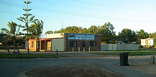
Meckering is a town 130 kilometres (80.8 mi) east of Perth, Western Australia along the Great Eastern Highway. Meckering is located within the Shire of Cunderdin.

Gnowangerup is a town located 61 kilometres (38 mi) south-east of Katanning in the Great Southern region of Western Australia.

Yealering is a town in the Wheatbelt region of Western Australia, approximately 220km south-east of Perth between the towns of Wickepin and Corrigin. It is located beside the lake of the same name. While the town's population is small, it services a large agricultural district in the northern Wickepin Shire. At the 2016 census, Yealering had a population of 104.

Trayning is a town in the north-eastern Wheatbelt region of Western Australia, 236 kilometres (147 mi) east of the state capital, Perth, on the Nungarin–Wyalkatchem Road. At the 2006 census, Trayning had a population of 122.

Nungarin is a town located in the north east of the Wheatbelt region of Western Australia, approximately 278 kilometres (173 mi) east of Perth and 39 kilometres (24 mi) north of Merredin. It is the main town in the Shire of Nungarin. At the 2006 census, Nungarin had a population of 142.

Merredin railway station is located on the Eastern Goldfields Railway in Western Australia. It is in the town of Merredin.
Gregory is a small town and fishing port located 7 km (4.3 mi) northwest of the mouth of the Hutt River, in the Mid West region of Western Australia. At the 2016 census, Gregory had a population of 64 in 83 dwellings. Most of the dwellings are holiday houses. The population of Gregory fluctuates depending on tourism; with the town at full capacity during school holidays and throughout the summer. During the census 50% of dwellings were unoccupied.

Kununoppin is a small town in the Wheatbelt region of Western Australia. The town is located on the Nungarin–Wyalkatchem Road and in the Shire of Trayning local government area, 257 kilometres (160 mi) north east of the state capital, Perth, Western Australia. At the 2006 census, Kununoppin had a population of 151.

Korrelocking is a small town situated between Wyalkatchem and Trayning in the Wheatbelt region of Western Australia. At the 2006 census, Korrelocking had a population of 76.
Elabbin is a small town between Merredin and Mukinbudin in the Wheatbelt region of Western Australia located in the Shire of Nungarin.
Walgoolan is a small town located in the eastern Wheatbelt region of Western Australia. It is situated between Merredin and Bodallin along the Great Eastern Highway.
Muntadgin is a townsite off the Great Eastern Highway on Brissenden Road, situated between the towns of Bruce Rock and Southern Cross in the Wheatbelt region of Western Australia. At the 2016 census, Muntadgin had a population of 51.

The wheatbelt railway lines of Western Australia were, in most cases, a network of railway lines in Western Australia that primarily served the Wheatbelt region.
Campion is an abandoned townsite in the Wheatbelt region of Western Australia, located in the Shire of Nungarin on the Koorda–Bullfinch Road. It is situated within the locality of Chandler, with the closest town being Mukinbudin.
Lake Brown is a rural locality in the Wheatbelt region of Western Australia, located in the Shire of Mukinbudin approximately 57 kilometres (35 mi) north of Merredin and approximately 260 kilometres (160 mi) east-north-east of Perth.


