Koojan, Western Australia

Last updated

Koojan
Western Australia
Australia Western Australia location map.svg
Red pog.svg
Koojan
Coordinates 30°48′S116°01′E / 30.800°S 116.017°E / -30.800; 116.017 Coordinates: 30°48′S116°01′E / 30.800°S 116.017°E / -30.800; 116.017
Established1910
Postcode(s) 6510
Elevation201 m (659 ft)
Location
  • 160 km (99 mi) north of Perth
  • 18 km (11 mi) south of Moora
LGA(s) Shire of Moora
State electorate(s) Moore
Federal Division(s) Durack

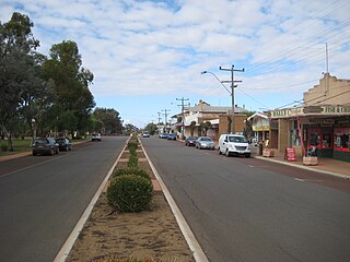
Koojan is a small town located between Moora and Bindoon in the Wheatbelt region of Western Australia.

Moora, Western Australia Town in Western Australia

Moora is a townsite located 177 km north of Perth in the Wheatbelt region of Western Australia. Moora was one of the original stations on the Midland railway line to Walkaway, and the townsite was gazetted in 1895. At the 2006 census, Moora had a population of 1,822.

Bindoon, Western Australia Town in Western Australia

Bindoon is a town 84 kilometres (52 mi) from Perth city on the Great Northern Highway within the Shire of Chittering. The name Bindoon is thought to be Aboriginal in origin and to mean "place where the yams grow". The name has been in use in the area since 1843 when an early settler, William Brockman, named the property he had surveyed as Bindoon. The townsite was gazetted in 1953.

Wheatbelt (Western Australia) region in Western Australia

The Wheatbelt is one of nine regions of Western Australia defined as administrative areas for the state's regional development, and a vernacular term for the area converted to agriculture during colonisation. It partially surrounds the Perth metropolitan area, extending north from Perth to the Mid West region, and east to the Goldfields-Esperance region. It is bordered to the south by the South West and Great Southern regions, and to the west by the Indian Ocean, the Perth metropolitan area, and the Peel region. Altogether, it has an area of 154,862 square kilometres (59,793 sq mi).

When the Midland railway was opened in 1894 the site of the present town was established as a railway siding. Some time afterward the area was surveyed and subdivided and the town was gazetted in 1910. [1]

Midland Railway of Western Australia

The Midland Railway of Western Australia (MRWA) was a railway company that built and operated the Midland line in Western Australia. It was listed on the London Stock Exchange. Although having its headquarters in London, it had no association with the English Midland Railway.

The town is named after the Aboriginal word for a nearby pool of the Moore River. The name was first recorded on maps which were surveyed in 1861 but the meaning of the word is unknown.

Moore River river in Western Australia

Moore River is a river in the Wheatbelt region of Western Australia.

Related Research Articles

Dalwallinu, Western Australia Town in Western Australia

Dalwallinu is a town in the Wheatbelt region of Western Australia, located 248 km from Perth via the Great Northern Highway. Agriculture and supporting industries are the town's primary economic activities. The town is also the first town on The Wildflower Way, a world-famous Western Australian tourist route which stretches north to Mullewa. The town has an elevation of 335 metres (1,099 ft). At the 2006 census, Dalwallinu had a population of 593.

Yalgoo, Western Australia Town in Western Australia

Yalgoo is a town in the Murchison region, 499 kilometres (310 mi) north-north-east of Perth and 118 kilometres (73 mi) east-north-east of Mullewa. Yalgoo is in the local government area of the Shire of Yalgoo.

Waroona, Western Australia Town in Western Australia

Waroona is a town located in the Peel region of Western Australia along the South Western Highway, between Pinjarra and Harvey. The town is the seat of the Shire of Waroona. At the 2011 census, Waroona had a population of 2,157.

Pinjarra, Western Australia Town in Western Australia

Pinjarra is a town in the Peel region of Western Australia along the South Western Highway, 86 kilometres (53 mi) from the state capital, Perth and 21 kilometres (13 mi) south-east of the coastal city of Mandurah. Its local government area is the Shire of Murray. At the 2011 census, Pinjarra had a population of 4,255.

Wyalkatchem, Western Australia Town in Western Australia

Wyalkatchem townsite is located in the central agricultural region, 192 kilometres (119 mi) east-north-east of Perth and 35 kilometres (22 mi) east of Dowerin. At the 2006 census, Wyalkatchem had a population of 344.

Meckering, Western Australia Town in Western Australia

Meckering is a town 130 km east of Perth, Western Australia along the Great Eastern Highway. Meckering is located within the Shire of Cunderdin.

Muchea is a suburb of the Shire of Chittering. Its postcode is 6501. The towns name comes from the Aboriginal word "Muchela" which means in Nyoongar 'water hole', referring to the abundance of water in Muchea.

Bencubbin, Western Australia Town in Western Australia

Bencubbin is a town in Western Australia in the North Eastern Wheatbelt, 275 km north-east of Perth. The town lies within the Shire of Mount Marshall and is home to approximately 294 people as of 2011. Surveyor General John Septimus Roe first surveyed the region in 1836 and he was followed by sandalwood cutters and stockmen, but it was not until 1908 that the first permanent settlers arrived.

Wandering, Western Australia Town in Western Australia

Wandering is a town located in the wheatbelt region of Western Australia, approximately 120 kilometres (75 mi) from the state capital, Perth, just off the Albany Highway. It is the main town in the Shire of Wandering. At the 2016 census, Wandering had a population of 294.

Trayning, Western Australia Town in Western Australia

Trayning is a town in the north-eastern Wheatbelt region of Western Australia, 236 kilometres (147 mi) east of the state capital, Perth, on the Nungarin–Wyalkatchem Road. At the 2006 census, Trayning had a population of 122.

Wundowie, Western Australia Town in Western Australia

Wundowie is a town in Western Australia located between Perth and Northam in the Darling Range. It was the location of an iron works, and siding and stopping place on the Eastern Railway.

Nyabing, Western Australia Town in Western Australia

Nyabing is a small town in the Great Southern region of Western Australia. The name is of Aboriginal origin and is thought to derive from the Aboriginal word "ne-yameng" which is the name of an everlasting flower Rhodanthe manglesii.

Manmanning, Western Australia Town in Western Australia

Manmanning is a small Wheatbelt town in Western Australia.

Watheroo, Western Australia Town in Western Australia

Watheroo is a small town in the Wheatbelt region of Western Australia. In 2016 it had 181 residents according to the 2016 census census.

Yelbeni, Western Australia Town in Western Australia

Yelbeni is a small town 222 km east-northeast of Perth, Western Australia along the Nungarin-Wyalkatchem Road situated in the Wheatbelt Region of Western Australia. At the 2006 census, Yelbeni had a population of 118.

Boolading, Western Australia Town in Western Australia

Boolading is a location located along the Coalfields Highway between Darkan and Collie in the Wheatbelt region of Western Australia.

Bindi Bindi, Western Australia Town in Western Australia

Bindi Bindi is a small town located between Moora and Wongan Hills in the Wheatbelt region of Western Australia. It has a population of 72. The town originated as a Western Australian Government Railways siding and was gazetted in 1947. The name is Aboriginal in origin and is the word for stick or skewer on which a coat is hung. The doubling of the word is to indicate many of them.

Korrelocking, Western Australia Town in Western Australia

Korrelocking is a small town situated between Wyalkatchem and Trayning in the Wheatbelt region of Western Australia. At the 2006 census, Korrelocking had a population of 76.

Erikin, Western Australia Town in Western Australia

Erikin is a small town located in the Eastern Wheatbelt region of Western Australia. It is located close to the Salt River and between the towns of Quairading and Bruce Rock.

Kumbarilla, Queensland Suburb of Western Downs Region, Queensland, Australia

Kumbarilla is a town and rural locality in the Western Downs Region, Queensland, Australia. In the 2006 census, Kumbarilla had a population of 241 people.

References

  1. Western Australian Land Information Authority. "History of country town names – K" . Retrieved 2011-03-20.