Moore River

Last updated

Moore River
Moore River Estuary.JPG
Moore River estuary at Guilderton
Location
CountryAustralia
Physical characteristics
Source 
  location Dalwallinu
  elevation310 m (1,017 ft) [1]
Mouth  
  location
Indian Ocean at Guilderton
  elevation
sea level
Length193 km (120 mi)
Basin size13,550 km2 (5,232 sq mi) [1]
Discharge 
  average60,860 ML/a (1.929 m3/s; 68.11 cu ft/s) [2]
Basin features
Tributaries 
  leftYadgena Brook, Moore River East
  rightCoonderoo River

Moore River (Garban) is a river in the Wheatbelt region of Western Australia.

Contents

Geography

The headwaters of the Moore River lie in the Perenjori, Carnamah and Dalwallinu Shires. The river then drains southwards through Moora, flows westerly before joining with the Moore River East near Mogumber, then flows in a westerly direction over the Edengerie Cascade, through the northern edge of the Moore River Nature Reserve, then through the Gingin Scarp, discharging into the Indian Ocean at Guilderton. [3]

The river includes a catchment that extends from just south of Three Springs to Guilderton. The catchment has a total area of 13,800 square kilometres (5,328 sq mi) and is 80% cleared for agriculture. [3] The catchment area is used for broadacre farming but with increasing diversification in horticulture and tree plantations. The river mouth at Guilderton typically closes during the summer months due to insufficient water flow, creating a sandbar.

The river has nine sub-catchment areas and has a number of tributaries and lakes along the length of the river. The salinity levels in the river catchment vary from brackish to saline with the exception of Gingin Brook which remains fresh throughout the year. [3]

History

The Aboriginal people referred to the lower part of the river as Garban. [4] White settlers named it River Moore in May 1836 by Corporal Patrick Heffron of the 63rd Regiment of Foot, after his expedition leader George Fletcher Moore, Advocate-General. The exploratory party comprised Moore, Heffron and an Aboriginal man named Weenat. [5] [6] Heffron was notable for his participation in the Pinjarra Massacre in 1834. [7]

The river is prone to periodic flooding unusually following cyclones and tropical depressions crossing the coast further north. In 1907, the railway lines between Watheroo and Moora were closed for some time when parts of the track were washed away. [8] More floods occurred in 1917 when 1.7 inches (43 mm) of rain fell in three hours at Mogumber with similar falls in surrounding areas. Moora was once again left underwater and rail services in surrounding areas were suspended. Low-lying areas in other towns such as Arrino, Three Springs, and Coorow were also submerged. [9]

In 1932, the river flooded once again following heavy rains in the Midland districts. Railway lines were undermined to a depth of 30 feet (9 m) leaving Moora isolated from Perth by both road and rail. The township of Moora was left 3 feet (1 m) underwater and portions of the town had to be evacuated. Crops and some stock were lost as a result of the floodwaters. [10]

Opened in 1918, near the head of the river, was the now defunct and discredited government-managed-settlement and internment camp known as the Moore River Native Settlement.

See also

Related Research Articles

<span class="mw-page-title-main">Avon River (Western Australia)</span> River in Western Australia, Australia

The Avon River is a river in Western Australia. A tributary of the Swan River, the Avon flows 240 kilometres (150 mi) from source to mouth, with a catchment area of 125,000 square kilometres (48,000 sq mi).

<span class="mw-page-title-main">Brand Highway</span> Highway in Western Australia

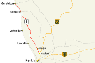
Brand Highway is a 370-kilometre (230 mi) main highway linking the northern outskirts of Perth to Geraldton in Western Australia. Together with North West Coastal Highway, it forms part of the Western Australian coastal link to the Northern Territory. The highway is a part of Australia's Highway 1, and is for the most part a single carriageway with one lane in each direction.

<span class="mw-page-title-main">Murchison River (Western Australia)</span> River in Western Australia

The Murchison River is the second longest river in Western Australia. It flows for about 820 km (510 mi) from the southern edge of the Robinson Ranges to the Indian Ocean at Kalbarri. The Murchison-Yalgar-Hope river system is the longest river system in Western Australia. It has a mean annual flow of 208 gigalitres, although in 2006, the peak year on record since 1967, flow was 1,806 gigalitres.

<span class="mw-page-title-main">Division of Moore</span> Australian federal electoral division

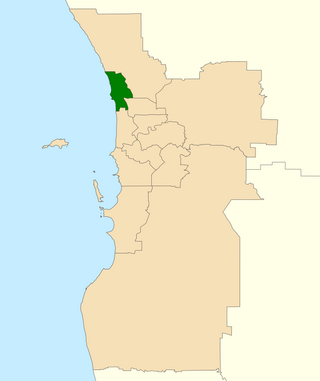
The Division of Moore is an Australian electoral division in the state of Western Australia.

<span class="mw-page-title-main">Coorow, Western Australia</span> Town in Western Australia

Coorow is a town in the Mid West region of Western Australia, 264 kilometres (164 mi) north of Perth.

<span class="mw-page-title-main">Moora, Western Australia</span> Town in the Wheatbelt region of Western Australia

Moora is a townsite located 177 km north of Perth in the Wheatbelt region of Western Australia. At the 2021 census, Moora had a population of 1,755.

<span class="mw-page-title-main">Gingin, Western Australia</span> Town in Western Australia

Gingin is a town in Western Australia, located on the Brand Highway 67 kilometres (42 mi) north of the Perth city centre. It is the council seat for the Shire of Gingin local government area. Gingin had a population of 852 at the 2016 census. The town's economy is mostly based on its agriculture, although there has been an increasing focus on science with the establishment of the Australian International Gravitational Observatory and Gravity Discovery Centre. There is also a small military airfield, RAAF Gingin, located nearby.

<span class="mw-page-title-main">Blackwood River</span> River in Western Australia

The Blackwood River is a major river and catchment in the South West of Western Australia.

<span class="mw-page-title-main">Electoral district of Moore</span> State electoral district of Western Australia

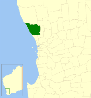
Moore is an electoral district of the Legislative Assembly in the Australian state of Western Australia.

<span class="mw-page-title-main">Guilderton, Western Australia</span> Town in Western Australia

Guilderton is a small coastal town north of Perth, Western Australia at the mouth of the Moore River in the Shire of Gingin.

Chittering is a town and rural district approximately 70 km NNE of Perth, Western Australia. It is located along the Brockman River within the Shire of Chittering. It lies between the towns of Gingin and Toodyay, in the Wheatbelt region.

<span class="mw-page-title-main">Shire of Gingin</span> Local government area in the Wheatbelt region of Western Australia

The Shire of Gingin is a local government area in the Wheatbelt region of Western Australia, just beyond the northern fringe of the Perth metropolitan area. The Shire covers an area of 3,211 square kilometres (1,240 sq mi) and its seat of government is the town of Gingin.

The Arrowsmith River lies within the Mid West region of Western Australia.

<span class="mw-page-title-main">Watheroo, Western Australia</span> Town in Western Australia

Watheroo is a small town in the Wheatbelt region of Western Australia. There are 137 residents, according to the 2021 census.

<span class="mw-page-title-main">Donnelly River (Western Australia)</span> River in Western Australia

The Donnelly River is a river in the South West of Western Australia. Its main tributaries are Barlee Brook and Carey Brook. The river runs primarily through state forest reserves, although 25 private landholdings are situated along the length of the river. Clearing of the catchment area is estimated at 20% with the land mostly being used for viticulture, horticulture, dairy, grazing and tourism.

The Yule River is an ephemeral river in the Pilbara region of Western Australia. It was named on 10 August 1861 by the surveyor and explorer Frank Gregory while on expedition in the area, after Thomas Newte Yule, at times farmer of Toodyay, winemaker, Acting Colonial Secretary and Magistrate.

The Nambung River is a river in the Wheatbelt region of Western Australia, 170 kilometres (106 mi) north of Perth. The river drains an area between the towns of Cervantes and Badgingarra. In its lower reaches the Nambung River forms a chain of waterholes in the Nambung Wetlands where it disappears underground into a limestone karst system 5.5 kilometres (3 mi) from the Indian Ocean.

<span class="mw-page-title-main">Yued</span> Region of indigenous people of Western Australia

Yued is a region inhabited by the Yued people, one of the fourteen groups of Noongar Aboriginal Australians who have lived in the South West corner of Western Australia for approximately 40,000 years.

Mogumber is a locality in Western Australia. It is in the Shire of Victoria Plains, and situated along the Bindoon Moora Road. Although it is a settlement, it is not officially a townsite. It is the location where the Moore River East joins the Moore River. As of the 2021 Australian census, Mogumber had a population of 58.

Gabbadah is a locality within the Shire of Gingin, located around 30 km north of Perth metropolitan area's northern limit.

References

  1. 1 2 Water Studies Pty Ltd (20 September 2008). "Moora Flood Management Study" (PDF). Shire of Moora. Water and Rivers Commission, Western Australia. p. 1. Retrieved 20 March 2018.
  2. "River Monitoring Station – Moore River – Quinns Ford". 2009. Archived from the original on 29 June 2009. Retrieved 12 March 2009.
  3. 1 2 3 Alderman, Angela; Clarke, Mike (October 2003). "Moore River Catchment Appraisal 2003" (PDF). Resource Management Technical Report, W.A. Department of Agriculture. 263. Archived from the original (PDF) on 22 July 2012. Retrieved 30 July 2012.
  4. Grey, George (1841). Journals of two expeditions of discovery in North-West and Western Australia, during the years 1837, 38, and 39, describing many newly discovered, important, and fertile districts, with observations on the moral and physical condition of the aboriginal inhabitants, etc. etc. Vol. 2. London: T. and W. Boone. p. 67. Retrieved 17 March 2012.
  5. Moore, George Fletcher (21 May 1836). "A new river discovered, by the Hon. G. F. Moore, Esq., on a recent excursion to the northward". The Perth Gazette and Western Australian Journal. Retrieved 30 July 2012.
  6. "History of river names – M". Western Australian Land Information Authority. Archived from the original on 19 April 2021. Retrieved 12 April 2009.
  7. Moore, George Fletcher (1884). "The colony". Diary of ten years eventful life of an early settler in Western Australia and also a descriptive vocabulary of the language of the aborigines. London: M. Wallbrook. Retrieved 30 July 2012.
  8. "A town under water". The Advertiser . Adelaide: National Library of Australia. 3 August 1907. p. 10. Retrieved 8 April 2013.
  9. "The Midland Line". The West Australian . Perth: National Library of Australia. 6 August 1917. p. 6. Retrieved 8 April 2013.
  10. "Country Floods. Midland towns suffer". Western Mail . Perth: National Library of Australia. 11 August 1932. p. 25. Retrieved 8 April 2013.

31°22′S115°29′E / 31.367°S 115.483°E / -31.367; 115.483