
The Margaret River is a river in southwest Western Australia. In a small catchment, it is the eponym of the town and tourist region of Margaret River.
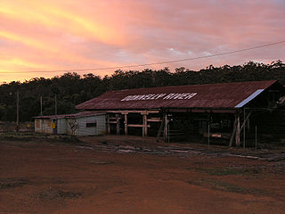
Donnelly River Village is a former timber mill town and present-day holiday village in the Shire of Nannup, in the South West region of Western Australia. The Village is located at a point between Nannup, Bridgetown and Manjimup on the Donnelly River, a small, seasonal river at this point, which flows into the Southern Ocean at 34°29′02.4″S115°40′27.8″E. The name also applies to a winery downstream on the Vasse Highway and the township's cottages are sometimes confused with cottages built on the lower reaches of the Donnelly River at 34°28′56″S115°41′00″E.
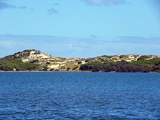
Leschenault Estuary is an estuarine lagoon that lies to the north of Bunbury, Western Australia. It had in the past met the Indian Ocean at the Leschenault Inlet, but that has been altered by harbour works for Bunbury, and the creation of The Cut north of the historical inlet location.

The Collie River is a river in the South West region of Western Australia.

The Carbunup River is located in the south-west corner of Western Australia. The mouth of the Carbunup River is approximately 20 kilometres (12 mi) west of Busselton where the river flows into Geographe Bay.

The Capel River is a river in the South West region of Western Australia that rises in the Darling Range east of Mullalyup, and flows into the Indian Ocean at Peppermint Grove Beach.
The Ferguson River originates on the eastern bank of Ferguson LakeA within the northern Hearne Domain, Western Churchill province of the Churchill craton, the northwest section of the Canadian Shield in Nunavut's Kivalliq Region.
The Oldfield River is an ephemeral river in the Goldfields-Esperance region of Western Australia that rises 95 kilometres (59 mi) inland from the South Coast at the edge of the Yilgarn plateau. The river starts at 300 metres (984 ft) above sea level then flows in a south easterly direction crossing the South Coast Highway near Munglinup.

The Preston River is a river in the South West region of Western Australia.
The Tone River is a river in the South West of Western Australia.

The Vasse River is a river in the South West of Western Australia.
The Ludlow River is a river in the South West region of Western Australia. It was named after Frank Ludlow, one of the first Western Australian colonists, an arrival on the barque Parmelia in 1829, who explored the locality in 1834.
The Abba River is a river in the South West region of Western Australia.
The Mortlock River is a perennial river in the Wheatbelt region of Western Australia.

Margaret River is the major geographical indication wine region in southwest Western Australia, with 5,840 hectares under vine and 215 wineries as at 2012. Margaret River wine region is made up predominantly of boutique size wine producers; although winery operations range from the smallest crushing 3.5 tonne per year to the largest around 2,500 tonne. The climate of Margaret River is more strongly maritime-influenced than any other major Australian region. It has the lowest mean annual temperature range, of only 7.6 °C, and as well as the most marked Mediterranean climate in terms of rainfall, with only 200 millimetres of the annual 1160 millimetres falling between October and April. The low diurnal and seasonal temperature range means an unusually even accumulation of warmth. Overall the climate is similar to that of Bordeaux in a dry vintage. Although the region produces just two percent of total Australian wine grape production, it produces over 20 percent of Australia's premium wine market. The principal grape varieties are split 40/60 between red and white; Cabernet Sauvignon, Chardonnay, Sauvignon blanc, Sémillon, Shiraz, Merlot and Chenin Blanc.
The Buayanyup River is a river in the South West region of Western Australia.
Fraser Range Station is a pastoral lease and sheep station located about 100 kilometres (62 mi) east of Norseman on the Eyre Highway in the Goldfields-Esperance region of Western Australia.
Spanggur Tso, also called Maindong Tso, Mendong Tso, is a saltwater lake in Rutog County in the Tibet Autonomous Region of China, close to the border with Ladakh. India claims a major portion of the lake as its own territory, as part of Ladakh. To the west of the lake lies the Spanggur Gap, a low pass through which the Line of Actual Control runs. To the north is the much larger lake Pangong Tso. Spanggur Tso is at an elevation of 4,305 meters and has an area of 61.6 square kilometres. The lake's average annual temperature is around -4 to -2 °C, and the annual precipitation is 50 to 75 mm. The western portion of the lake is claimed by India.
The Lunenburgh River is a perennial river in the South West region of Western Australia.

Ferguson is a rural locality of the Shire of Dardanup in the South West region of Western Australia. The locality of Ferguson and the Ferguson Valley are marketed as a tourist destination. The Ferguson River runs through the locality, which was named after John Ferguson who owned a property along the river, by the surveyor H.M. Ommanney in 1844.
