Margaret River (Kimberley, Western Australia)

Last updated

Margaret River
Margaret River in Flood.jpg
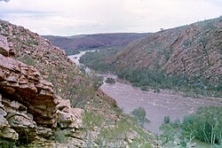
Margaret River in flood at the entrance to the Wunaamin-Miliwundi Ranges
Location
Country Australia
Physical characteristics
Source 
  location Wunaamin-Miliwundi Ranges
  elevation498 metres (1,634 ft) [1]
Mouth  
  location
Fitzroy River
  elevation
110 metres (361 ft)
Length335 kilometres (208 mi) [2]

The Margaret River is a river in the Kimberley region of Western Australia.

The river was named on 29 May 1879 by the explorer Alexander Forrest, during an expedition in the Kimberley area, after his sister-in-law Margaret Elvire Forrest, wife of his brother and superior, Deputy Surveyor-General John Forrest, who was later to be Premier of Western Australia. [3]

The headwaters of the river rise in the Wunaamin-Miliwundi Ranges west of Halls Creek and flow in a westerly direction until merging with the Fitzroy River. The junction of the two rivers is close to Fitzroy Crossing. The Margaret River has 15 tributaries including: Mary River, Gliddon River, O'Donnell River, Leopold River, Louisa River, Station Creek, Dead Horse Creek, Gidgia Creek and Boab Creek.

The state Public Works Department set up a flow monitoring station on the Margaret River at the entrance of the gorge where it enters the Mueller Ranges in 1966. Debate continues about the use of the Fitzroy River basin as a water source for the South West of Western Australia.

Fish such as the barramundi, freshwater sawfish, Greenway's grunter and the false-spine catfish have all been found within the river system. [4]

The traditional owners of the areas around the river are the Djaru, Gidja and Gooniyandi peoples. [5]
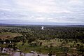
Related Research Articles

<span class="mw-page-title-main">Alexander Forrest</span> Australian politician

Alexander Forrest CMG was an explorer and surveyor of Western Australia, and later also a member of parliament.

<span class="mw-page-title-main">Kimberley (Western Australia)</span> Region in Western Australia

The Kimberley is the northernmost of the nine regions of Western Australia. It is bordered on the west by the Indian Ocean, on the north by the Timor Sea, on the south by the Great Sandy and Tanami deserts in the region of the Pilbara, and on the east by the Northern Territory.

<span class="mw-page-title-main">Fitzroy Crossing, Western Australia</span> Town in Western Australia

Fitzroy Crossing is a small town in the Kimberley region of Western Australia, 400 kilometres (250 mi) east of Broome and 300 kilometres (190 mi) west of Halls Creek. It is approximately 2,524 kilometres (1,568 mi) from the state capital of Perth. It is 114 metres (374 ft) above sea level and is situated on a low rise surrounded by the vast floodplains of the Fitzroy River and its tributary Margaret River.

<span class="mw-page-title-main">Fitzroy River (Western Australia)</span> River in Western Australia

The Fitzroy River is located in the West Kimberley region of Western Australia. It has 20 tributaries and its catchment occupies an area of 93,829 square kilometres (36,228 sq mi), within the Canning Basin and the Timor Sea drainage division.

<span class="mw-page-title-main">Wunaamin Miliwundi Ranges</span> Mountain range in Western Australia

The Wunaamin Miliwundi Ranges are a range of hills in the western Kimberley region of Western Australia.

<span class="mw-page-title-main">Shire of Derby–West Kimberley</span> Local government area in Western Australia

The Shire of Derby–West Kimberley is one of four local government areas in the Kimberley region of northern Western Australia, covering an area of 104,080 square kilometres (40,186 sq mi), most of which is sparsely populated. The Shire's population as at the 2016 Census was almost 8,000, with most residing in the major towns of Derby, which is also the Shire's seat of government, and Fitzroy Crossing. There are also around 70 Aboriginal communities within the Shire.

<span class="mw-page-title-main">Lennard River</span> River in Kimberley region of Western Australia

Lennard River is a river in the Kimberley region of Western Australia. The river was named on 8 June 1879 by the explorer Alexander Forrest, during an expedition in the Kimberley area, after Amy Eliza Barrett-Lennard (1852-1897), who he was to marry on 15 January 1880.

The Hann River is a river in the Kimberley region of Western Australia.

The Adcock River is a river in the Kimberley region of Western Australia.

<span class="mw-page-title-main">Prince Regent River</span> River in Kimberley region of Western Australia

The Prince Regent River is a river in the Kimberley region of Western Australia.

<span class="mw-page-title-main">Louisa Downs Station</span> Pastoral lease in Western Australia

Louisa Downs, also commonly just referred to as "Louisa", is a large cattle station midway between Fitzroy Crossing and Halls Creek in the Kimberley region in Western Australia.

The Behn River or Behm River is a river in the Kimberley region of Western Australia.

<span class="mw-page-title-main">Fossil Downs Station</span> Station in North East of Fitzroy Crossing, Western Australia

Fossil Downs Station is a pastoral lease and cattle station located about 50 kilometres (31 mi) north east of Fitzroy Crossing in the Kimberley region of Western Australia.

<span class="mw-page-title-main">Barnett River</span> River in Western Australia

The Barnett River is a river in the Kimberley region of Western Australia.

<span class="mw-page-title-main">Gogo Station</span> Pastoral lease in Western Australia

Gogo or Gogo Station and sometimes referred to as Margaret Downs is a pastoral lease that has operated as a cattle station. It is located about 11 kilometres (7 mi) south of Fitzroy Crossing and 83 kilometres (52 mi) north east of Yungngora in the Kimberley region of Western Australia,

<span class="mw-page-title-main">Yeeda Station</span> Pastoral lease in Western Australia

Yeeda Station is a pastoral lease that operates as a cattle station in the Kimberley region of Western Australia.

<span class="mw-page-title-main">Devonian Reef</span>

The Balili Conservation Park or Devonian Reef Conservation Park is an Australian protected area and is located in the Kimberley region of Western Australia, about 50km North-West of Fitzroy Crossing. It includes Geikie Gorge National Park, Tunnel Creek National Park and Windjana Gorge National Park.

Quanbun Station, also known as Quanbum and Quanbun Downs, is a pastoral lease and cattle station located about 40 kilometres (25 mi) south west of Fitzroy Crossing in the Kimberley region of Western Australia.

The Gooniyandi, also known as the Konejandi, are an Aboriginal Australian people in the Kimberley region of Western Australia.

References

  1. "Bonzle Digital Atlas – Map of Margaret River". 2009. Retrieved 10 July 2016.
  2. "History of river names – M". Western Australian Land Information Authority. Retrieved 7 September 2011.
  3. Forrest, Alexander (8 February 1880). "From the De Grey to Port Darwin: Journal of Exploration". The West Australian . p. 1S. Retrieved 19 August 2013.
  4. "National River Trust – Inland fish fauna of the Fitzroy river" (PDF). 2002. Retrieved 17 September 2010.
  5. "AusAnthrop Australian Aboriginal tribal database". 2012. Archived from the original on 29 February 2012. Retrieved 6 May 2012.

18°10′24″S125°37′5″E / 18.17333°S 125.61806°E / -18.17333; 125.61806