King George River

Last updated

King George
King George Falls.jpg
King George Falls
Australia relief map.jpg
Red pog.svg
Location of the King George River mouth
in Western Australia
EtymologyIn honour of King George V [1]
Location
Country Australia
State Western Australia
Region Central and Northern Kimberley, Victoria Bonaparte (IBRA)
Local government area Wyndham-East Kimberley
Physical characteristics
SourceAshton Range
  locationOombulgurri Aboriginal Reserve, Central Kimberley
  coordinates 14°37′24″S127°11′59″E / 14.62333°S 127.19972°E / -14.62333; 127.19972
  elevation212 m (696 ft)
Mouth Koolama Bay, Timor Sea
  location
east of Kalumburu , Northern Kimberley
  coordinates
13°57′44″S127°19′43″E / 13.96222°S 127.32861°E / -13.96222; 127.32861 Coordinates: 13°57′44″S127°19′43″E / 13.96222°S 127.32861°E / -13.96222; 127.32861
  elevation
0 m (0 ft)
Length112 km (70 mi)
Basin features
Tributaries 
  leftBeta Creek
WaterfallsKing George Falls
National park Drysdale River National Park
[2]

The King George River is a perennial river located in the Kimberley region of Western Australia.

Contents

Location and features

The headwaters of the river rise to the west of the Ashton Range and flow in a northerly direction through the Drysdale River National Park past the Seppelt Range, joined by one minor tributary before reaching its river mouth and emptying into Koolama Bay and the Timor Sea, approximately 70 kilometres (43 mi) east of Kalumburu . The river descends 216 metres (709 ft) over its 112-kilometre (70 mi) course, [2] including a 38–40-metre (125–131 ft) descent over the dual drop waterfall of King George Falls, approximately 12 kilometres (7.5 mi) upriver from the river mouth. The falls are located at an elevation of 84 metres (276 ft) above sea level. [3]

The recorded height of the waterfall varies widely, with some sources claiming the descent is in the range of 80–100 metres (262–328 ft). [4] [5] [6] [7] [8] The area surrounding the falls are popular with tourists, who typically view the falls by boat. [4] [5] The falls are in full force from late December through to early May each year and gradually recede to a small flow in September. [6] The falls were featured in Baz Luhrmann's 2008 film, Australia. [8]

Etymology

The river was named in 1911 by explorer Charles Conigrave after a privately funded expedition in the area. The river is named in honour of King George V. [1]

The traditional owners of the areas around the river are the Miwa people. [9]

See also

Related Research Articles

Wollomombi Falls Waterfall on the Wollomombi River in New South Wales, Australia

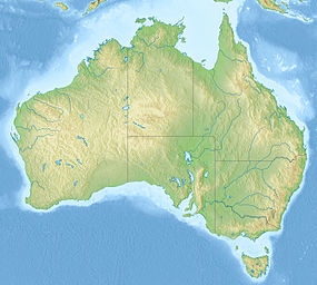
The Wollomombi Falls is a plunge waterfall on the Wollomombi River in the New England region of New South Wales, Australia.

Barron River (Queensland) River in Queensland, Australia

The Barron River is located on the Atherton Tablelands inland from Cairns in northern Queensland, Australia. With its headwaters below Mount Hypipamee, the 165-kilometre (103 mi)-long river with a catchment area of approximately 2,138 square kilometres (825 sq mi) forms through run off from the Mount Hypipamee National Park, flows through Lake Tinaroo, and eventually empties into the Coral Sea near Smithfield.

Fitzroy River (Western Australia) River in Western Australia

The Fitzroy River is located in the West Kimberley region of Western Australia. It has 20 tributaries and its catchment occupies an area of 93,829 square kilometres (36,228 sq mi), within the Canning Basin and the Timor Sea drainage division.

Wunaamin Miliwundi Ranges Mountain range in Western Australia

The Wunaamin Miliwundi Ranges, formerly known as the King Leopold Ranges between 1879 and 2020, are a range of hills in the western Kimberley region of Western Australia.

Herbert River River located in Far North Queensland, Australia

The Herbert River is a river located in Far North Queensland, Australia. The southernmost of Queensland's wet tropics river systems, it was named in 1864 by George Elphinstone Dalrymple explorer, after Robert George Wyndham Herbert, the first Premier of Queensland.

Twin Falls (Northern Territory) Waterfall in Northern Territory, Australia

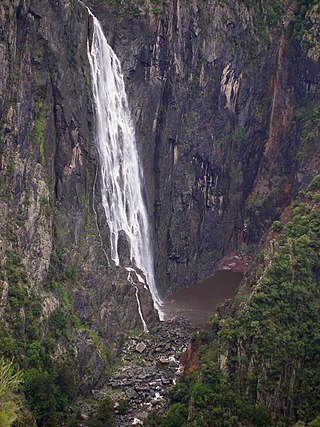
The Twin Falls is a cascade waterfall on the South Alligator River that descends over the Arnhem Land escarpment within the UNESCO World Heritage–listed Kakadu National Park in the Northern Territory of Australia. In 1980, The Twin Falls area was listed on the now-defunct Register of the National Estate.

Wangi Falls Waterfall in Australia

The Wangi Falls is a segmented waterfall on the Wangi Creek located within the Litchfield National Park in the Northern Territory of Australia.

The Tjaynera Falls is a waterfall on the Sandy Creek that is located within the Litchfield National Park in the Northern Territory of Australia.

Tolmer Falls Waterfall in Northern Territory, Australia

The Tolmer Falls is a plunge waterfall on the Tolmer Creek that is located in the Litchfield National Park in the Northern Territory of Australia.

The Herbert River Falls is a plunge waterfall on the Herbert River that is located in the UNESCO World Heritage–listed Wet Tropics in the Far North region of Queensland, Australia.

Blencoe Falls Waterfall in Far North, Queensland, Australia

The Blencoe Falls is a segmented waterfall on the Blencoe Creek, located in the Far North region of Queensland, Australia.

Dip Falls Waterfall in North West Tasmania, Australia

The Dip Falls, a cascade waterfall over cubic-basalt formed rocks on the Dip River, is located in Mawbanna in the North West region of Tasmania, Australia.

Hopetoun Falls Waterfall in Victoria, Australia

The Hopetoun Falls is a waterfall across the Aire River that is located in The Otways region of Victoria, Australia.

Edith Falls Waterfall in Northern Territory, Australia

The Edith Falls is a series of cascading waterfalls and pools on the Edith River in the Nitmiluk National Park, located approximately 60 kilometres (37 mi) north of Katherine, in the Northern Territory of Australia.

Waychinicup River River in Western Australia

The Waychinicup River is located in the Great Southern region of Western Australia. The headwaters of the river are located near the town of Manypeaks along the South Coast Highway, with an elevation of approximately 100 metres (328 ft) above sea level and flows in a generally southerly direction through the Mount Manypeaks Range then through the Waychinicup National Park until it discharges into the Southern Ocean.

Tully Falls

The Tully Falls, a horsetail chute waterfall on the Tully River, is located in the UNESCO World Heritage–listed Wet Tropics in the Far North region of Queensland, Australia. It formed the eastern boundary of the Dyirbal.

Drysdale River River in Kimberley region of Western Australia

Drysdale River is a river in the Kimberley region of Western Australia.

Hunter River (Western Australia) River in Western Australia

The Hunter River is a river in the Kimberley region of Western Australia.

Aire River (Victoria) River in Victoria, Australia

The Aire River is a perennial river of the Corangamite catchment, located in The Otways region of the Australian state of Victoria.

Steavenson River

The Steavenson River, sometimes incorrectly referred to as Steavensons River, a minor inland perennial river of the Goulburn Broken catchment, part of the Murray-Darling basin, is located in the lower South Eastern Highlands bioregion and Northern Country/North Central regions of the Australian state of Victoria. The headwaters of the Steavenson River rise on the north–western slopes of the Yarra Ranges, below Mount Edgar and descend to flow into the Acheron River near Buxton.

References

  1. 1 2 "History of river names – K". Western Australian Land Information Authority. Retrieved 7 September 2011.
  2. 1 2 "Map of King George River, WA". Bonzle Digital Atlas of Australia. Retrieved 17 November 2014.
  3. "Map of King George Falls, WA". Bonzle Digital Atlas of Australia. Retrieved 17 November 2014.
  4. 1 2 "King George Falls – Top Waterfalls in the World". World Top Top. Retrieved 17 November 2014.
  5. 1 2 "King George River" (PDF) (PDF). Kimberley Coast Cruising Yacht Club. 18 November 2013. Archived from the original (PDF) on 1 March 2015. Retrieved 17 November 2014.
  6. 1 2 "King George Twin Falls". Western Australia for everyone. Phoenix Group Co. 2013. Archived from the original on 29 November 2014. Retrieved 17 November 2014.
  7. "Australia's North West: Top 10 Attractions". DriveWA.com. DriveOz Pty Ltd. Archived from the original on 29 November 2014. Retrieved 17 November 2014.
  8. 1 2 "King George Falls". Faraway Bay. Retrieved 17 November 2014.
  9. "AusAnthrop Australian Aboriginal tribal database". 2012. Archived from the original on 29 November 2014. Retrieved 6 May 2012.