Helena River

Last updated

Helena River
Mundaring Weir SMC4.jpg
The Helena River at Mundaring Weir. The building on the right is the original Number 1 pump station for the Goldfields Pipeline.
Helena River
Location
Country Australia

The Helena River is a tributary of the Swan River in Western Australia. The river rises in country east of Mount Dale and flows north-west to Mundaring Weir, where it is dammed. It then flows west until it reaches the Darling Scarp.

Contents

It passes through the western edge of the Darling Scarp between Gooseberry Hill, and Greenmount Hill before joining the Swan River at the southern edge of the historic town, now suburb, of Guildford.

Catchment area

Many of the tributaries of the Helena River are unnamed due to their seasonality and size. However, Nyaania Creek on the northern side of the catchment and Piesse Brook on the southern side are significant through moving through built up areas, which also makes them susceptible to urban environment issues.

Upper Helena catchment (i.e. above Mundaring Weir) has on the north side of Lake C.Y. O'Connor (formerly the Helena River Reservoir) a range of named creeks that occur in State Forest no 71 and 13:

Environment

In higher ground the Helena River passes mainly through State Forest or reserve. This has been beneficial for some of the catchment area, as it has been an important buffer between the urban settlements in the Mundaring and Kalamunda areas. The flora of the Helena Valley has been recognised as being of importance because of the relative richness.

At Darlington, and the locality of Helena Valley there is housing and agriculture on its banks before it emerges out on to the Swan Coastal Plain.

At Bellevue and Midland the river has historically passed hazardous industrial sites. This includes the Midland Railway Workshops site and the Midland livestock sale yards.

Dams

It is dammed in two places – the best known is the upper river dam known as Mundaring Weir which was part of C.Y O'Connor's Goldfields Water Supply Scheme.

The Pipehead Dam area in 2012. Lower Helena pipehead dam from north west.jpg
The Pipehead Dam area in 2012.

Since the lower dam – known as the Lower Helena Pipehead Dam has been constructed in the 1970s, flooding of the lower Helena River (in East Guildford and Guildford) has been substantially reduced. Most of the water collected in the Pipehead Dam is pumped back into Mundaring Weir.

Due to this, restrictions in the Helena River catchment have been made to not allow activities that affect the quality of the Pipehead Dam – despite being adjacent to the built up areas within the Shire of Mundaring on the north side of the Helena River catchment. [1] [2]

Bridges

The bridges design and strength were relevant to higher water flow prior to the construction of the Pipehead Dam, as significant flooding occurred in the early and mid twentieth century.

The main bridges are at: –

Notes

  1. Western Australian Planning Commission; Western Australia. Water and Rivers Commission (2003), Middle Helena catchment area land use and water management strategy : published by the Western Australian Planning Commission for public comment, August 2003, Western Australian Planning Commission, ISBN   978-0-7309-9393-3
  2. Western Australian Planning Commission (2010), Middle Helena catchment area land use and water management strategy, Western Australian Planning Commission, ISBN   978-0-7309-9976-8
  3. 1 2 3 4 5 6 7 "Road Information Mapping". Main Roads, Western Australia. 4 April 2017. Archived from the original on 14 May 2013. Retrieved 22 April 2017.

Related Research Articles

<span class="mw-page-title-main">Swan River (Western Australia)</span> River in Perth, Western Australia

The Swan River is a major river in the southwest of Western Australia. The river runs through the metropolitan area of Perth, Western Australia's capital and largest city.

<span class="mw-page-title-main">Darling Scarp</span> Scarp east of Perth, Western Australia

The Darling Scarp, also referred to as the Darling Range or Darling Ranges, is a low escarpment running north–south to the east of the Swan Coastal Plain and Perth, Western Australia. The escarpment extends generally north of Bindoon, to the south of Pemberton. The adjacent Darling Plateau goes easterly to include Mount Bakewell near York and Mount Saddleback near Boddington. It was named after the Governor of New South Wales, Lieutenant-General Ralph Darling.

Mount Helena is a suburb on the outskirts of Perth, in Western Australia, 35 km from the city, in the Shire of Mundaring. Its population in 2016 was 3,185 people.

<span class="mw-page-title-main">Eastern Railway (Western Australia)</span> Railway line in Western Australia

The Eastern Railway is the main railway route between Fremantle and Northam in Western Australia. It opened in stages between 1881 and 1893. The line continues east to Kalgoorlie as the Eastern Goldfields Railway.

<span class="mw-page-title-main">Bellevue, Western Australia</span> Suburb of Perth, Western Australia

Bellevue is an eastern suburb of Perth, Western Australia in the local government areas of the City of Swan and the Shire of Mundaring. It is at the foot of the slopes of Greenmount, a landmark on the Darling Scarp that is noted in the earliest of travel journals of the early Swan River Colony.

<span class="mw-page-title-main">Railway Reserves Heritage Trail</span> Trail in Shire of Mundaring, Western Australia

The Railway Reserves Heritage Trail – also on some maps as Rail Reserve Heritage Trail or Rail Reserves Historical Trail, and frequently referred to locally as the Bridle Trail or Bridle Track – is within the Shire of Mundaring in Western Australia.

<span class="mw-page-title-main">Mundaring Weir Branch Railway</span> Former railway line in Mundaring, Western Australia

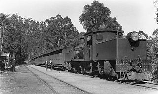
The Mundaring Weir Branch Railway was constructed from Mundaring, Western Australia to the site of the Mundaring Weir, and opened on 1 June 1898.

The Mundaring Branch Railway is a historical section of the original Eastern Railway main line across the Darling Scarp in the Western Australian Government Railways (WAGR) system.

<span class="mw-page-title-main">Chidlow, Western Australia</span> Suburb of Perth, Western Australia

Chidlow is a small community in the Shire of Mundaring approximately 45 kilometres east of Perth, Western Australia.

<span class="mw-page-title-main">Mundaring Weir</span> Reservoir in Mundaring, Western Australia

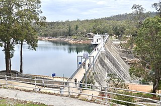
Mundaring Weir is a concrete gravity dam located 39 kilometres (24 mi) from Perth, Western Australia in the Darling Scarp. The dam and reservoir form the boundary between the suburbs of Reservoir and Sawyers Valley. The dam impounds the Helena River.

Wooroloo is a town on the outer fringe of the Perth metropolitan region, located off Great Eastern Highway in the eastern part of the Shire of Mundaring. At the 2021 census, Wooroloo had a population of 2,613.

<span class="mw-page-title-main">Mahogany Creek, Western Australia</span> Suburb of Perth, Western Australia

Mahogany Creek is a suburb of Perth, the state capital of Western Australia. It is part of the Shire of Mundaring local government area.

<span class="mw-page-title-main">Sawyers Valley, Western Australia</span> Suburb of Perth, Western Australia

Sawyers Valley is sited on the Great Eastern Highway about 40 kilometres from Perth, Western Australia in the Shire of Mundaring. The community began as a sawmill and railway siding to process timber from the forest surrounding the Helena River to the south. Local employment included forest and Goldfields Water Supply Scheme maintenance, small orchards, and the Midland Railway Workshops. The suburb's name comes from the occupation of many of the first European settlers to the area in the 1860s, who were sawyers working at the local saw-pits. The Sawyers Valley Tavern, which sits on the Highway opposite the Railway Reserve Heritage Trail, was first established in 1882 and the Sawyers Valley railway station was built in 1884.

<span class="mw-page-title-main">Helena Valley, Western Australia</span> Suburb of Perth, Western Australia

Helena Valley is the name of a river valley and a locality in the foothills of the Darling Scarp in Perth, Western Australia.

<span class="mw-page-title-main">Lake Leschenaultia</span> Lake in Perth, Western Australia

Lake Leschenaultia, Western Australia is a former railway dam that is now a recreational lake in the Shire of Mundaring just north of the location of an important railway stopping place on the original Eastern Railway. The dam holds approximately 520 million litres of water.

<span class="mw-page-title-main">Nyaania Creek</span> Seasonal creek in Western Australia

Nyaania Creek is a creek in Western Australia. It is a seasonal tributary that flows into the Helena River with a catchment that moves through a number of hills suburbs just east of the Darling Scarp. Its source is in Mahogany Creek, and it flows through Glen Forrest, Darlington, and Boya before meeting the Helena River at Helena Valley.

<span class="mw-page-title-main">Goldfields Water Supply Scheme</span> Pipeline and dam project in Western Australia

The Goldfields Water Supply Scheme is a pipeline and dam project that delivers potable water from Mundaring Weir in Perth to communities in Western Australia's Eastern Goldfields, particularly Coolgardie and Kalgoorlie. The project was commissioned in 1896 and completed in 1903.

<span class="mw-page-title-main">Mundaring Weir Road</span> Road in Perth, Western Australia

Mundaring Weir Road is a road in the outer eastern suburbs of Perth, Western Australia that links Mundaring and Kalamunda.

<span class="mw-page-title-main">Canning Contour Channel</span>

The Canning Contour Channel is a 16 kilometres (9.9 mi) series of man-made concrete channels and steel and cast-iron pipelines in the Darling Scarp in Western Australia constructed between July 1935 and December 1936. The project was a Depression era public works scheme to carry potable water from just below Canning Dam through the hills around and above Roleystone and Kelmscott to a screening, fluoridation and pumping station near Gosnells by following the natural contours of the Canning Valley—hence it was entirely gravity-fed. Where a tributary valley needed to be crossed, suspended or siphoning pipelines were used. From Gosnells, the water entered the city's pipeline distribution system.

<span class="mw-page-title-main">Lower Helena Pipehead Dam</span> Dam in Western Australia

The Lower Helena Pipehead Dam, also known as the Lower Helena Pumpback Dam, catchment and pipeline are a part of the Goldfields Water Supply operations at Mundaring Weir, some distance east in the same valley, in the Darling Range in Western Australia.

References

31°54′S116°00′E / 31.900°S 116.000°E / -31.900; 116.000