Related Research Articles

The Port River is part of a tidal estuary located north of the Adelaide city centre in the Australian state of South Australia. It has been used as a shipping channel since the beginning of European settlement of South Australia in 1836, when Colonel Light selected the site to use as a port. Before colonisation, the Port River region and the estuary area were known as Yerta Bulti by the Kaurna people, and used extensively as a source of food and plant materials to fashion artefacts used in daily life.

The Murchison River is the second longest river in Western Australia. It flows for about 820 km (510 mi) from the southern edge of the Robinson Ranges to the Indian Ocean at Kalbarri. The Murchison-Yalgar-Hope river system is the longest river system in Western Australia. It has a mean annual flow of 208 gigalitres, although in 2006, the peak year on record since 1967, flow was 1,806 gigalitres.

The Berowra Creek, a watercourse that is part of the Hawkesbury-Nepean catchment, is located to the north of the Sydney central business district in the Hornsby Shire of New South Wales, Australia.

The Peel-Harvey Estuarine System is a natural estuarine system that lies roughly parallel to the coast of Western Australia and south of the town of Mandurah.
Leschenault Estuary is an estuarine lagoon that lies to the north of Bunbury, Western Australia. It had in the past met the Indian Ocean at the Leschenault Inlet, but that has been altered by harbour works for Bunbury, and the creation of The Cut north of the historical inlet location.

The Fitzgerald River is a river in the Great Southern region of Western Australia.

The black bream, also commonly known as the southern black bream, southern bream and blue-nosed bream, is a species of anadromous ray-finned fish of the porgy family Sparidae. A deep-bodied fish, it is occasionally confused with other similar species that occur within its range, but is generally distinguished from these species by a lack of yellow ventral and anal fins. Southern black bream are endemic to the southern coasts of Australia from Shark Bay in Western Australia to Ulladulla, New South Wales, as well as Tasmania.

Stokes Inlet is an inlet in the Goldfields-Esperance region of Western Australia.

The Preston River is a river in the South West region of Western Australia.

The Vasse River is a river in the South West of Western Australia.
Irwin Inlet is an inlet in the located on the Great Southern region of Western Australia.
The Phillips River is an ephemeral river in the Goldfields-Esperance region of Western Australia.
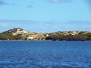
Culham Inlet is an inlet located in the Goldfields-Esperance region of Western Australia. The inlet is also referred to as a coastal salt lake or a transient estuary, as the sand bar that prevents it discharging is almost always closed. The wetlands formed by the system are DIWA listed due to their ecological significance.
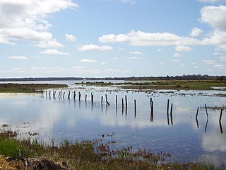
The Vasse-Wonnerup Estuary is an estuary in the South West region of Western Australia close to the town of Busselton. The estuary is listed with DIWA. It was also recognised as a wetland of international importance under the Ramsar Convention on 7 June 1990 when an area of 1,115 ha was designated Ramsar Site 484 as an important dry-season habitat for waterbirds. It is also the main part of the 2,038 ha (5,040-acre) Busselton Wetlands Important Bird Area.
Oldfield Estuary is an estuary in the Goldfields-Esperance region of Western Australia.
Gordon Inlet is an estuarine inlet, located in the Goldfields-Esperance region of Western Australia. The inlet is at the south west corner of the Fitzgerald River National Park and approximately 15 kilometres (9 mi) north west of the town of Bremer Bay.
The Hamersley River is an ephemeral river in the Great Southern region of Western Australia.
Beaufort Inlet also locally known as Pallinup Estuary is an inlet located in the Great Southern region of Western Australia about 130 kilometres (81 mi) east of Albany.
The estuaries of Western Australia are located along the coastline of Western Australia.
References
- ↑ "Bonzle Digital Atlas – Map of Steere River". 2009. Retrieved 16 March 2009.
- ↑ "History and management of Culham Inlet, a coastal salt lake in south-western Australia" (PDF). 1997. Retrieved 16 April 2009.
- ↑ "Our living waters - The Phillips, West and Steere Rivers". 2006. Retrieved 16 April 2009.
- ↑ "Estuary Assessment Framework for Non-pristine estuaries - Estuary 638 - Culham Inlet". 2004. Archived from the original on 23 May 2009. Retrieved 16 April 2009.
- ↑ "South Coast Rivercare - Steere River". 2005. Retrieved 16 April 2009.
33°53′22″S120°05′23″E / 33.88944°S 120.08972°E
Rivers of Western Australia | |
|---|---|
| Rivers of the Gascoyne region | |
| Rivers of the Goldfields-Esperance region | |
| Rivers of the Great Southern region | |
| Rivers of the Kimberley region |
|
| Rivers of the Mid West region | |
| Rivers of the Peel and Perth regions | |
| Rivers of the Pilbara region | |
| Rivers of the South West region | |
| Rivers of the Wheatbelt region | |