
The Swan River is a major river in the southwest of Western Australia. The river runs through the metropolitan area of Perth, Western Australia's capital and largest city.
Upper Swan is an outer suburb of Perth, Western Australia, located 33 kilometres (21 mi) north-east of Perth's central business district in the City of Swan. The locality sits at the confluence of the Swan River, the Millendon Junction to Narngulu railway line and Great Northern Highway, which is where the main suburban townsite is located. The rest of the locality is characterised by rural and industrial land uses such as vineyards, equestrian estates and quarries.
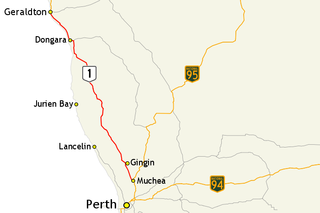
Brand Highway is a 370-kilometre (230 mi) main highway linking the northern outskirts of Perth to Geraldton in Western Australia. Together with North West Coastal Highway, it forms part of the Western Australian coastal link to the Northern Territory. The highway is a part of Australia's Highway 1, and is for the most part a single carriageway with one lane in each direction.

Great Northern Highway is an Australian highway that links Western Australia's capital city Perth with its northernmost port, Wyndham. With a length of almost 3,200 kilometres (2,000 mi), it is the longest highway in Australia, with the majority included as part of the Perth Darwin National Highway. The highway, which travels through remote areas of the state, is constructed as a sealed, predominantly two-lane single carriageway, but with some single-lane bridges in the Kimberley. Economically, it provides vital access through the Wheatbelt and Mid West to the resource-rich regions of the Pilbara and Kimberley. In these areas, the key industries of mining, agriculture and pastoral stations, and tourism are all dependent on the highway.

The Helena River is a tributary of the Swan River in Western Australia. The river rises in country east of Mount Dale and flows north-west to Mundaring Weir, where it is dammed. It then flows west until it reaches the Darling Scarp.

Belhus is a rural north-eastern suburb of Perth, Western Australia within the City of Swan. It is located in the north of the Swan Valley region, at the confluence of the Swan River and the Ellen Brook.

Ellenbrook is an outer suburb and planned community in Perth, Western Australia, within the City of Swan. It is 28 km (17 mi) north-east of Perth's central business district and 18 km (11 mi) north of the Swan city centre of Midland. It was developed in the 1990s as a joint venture between the Government of Western Australia and private landowners in the area.
Tonkin Highway is an 81-kilometre-long (50 mi) north–south highway and partial freeway in Perth, Western Australia, linking Perth Airport and Kewdale with the city's north-eastern and south-eastern suburbs. As of April 2020, the northern terminus is at the interchange with Brand Highway and Great Northern Highway in Muchea, and the southern terminus is at Thomas Road in Oakford. It forms the entire length of State Route 4, and connects to several major roads. Besides Brand Highway and Great Northern Highway, it also connects to Reid Highway, Great Eastern Highway, Leach Highway, Roe Highway, and Albany Highway.
Henley Brook is an outer suburb of Perth, Western Australia, located in Perth's Swan Valley region. It is 25 kilometres (16 mi) north-east of Perth's central business district in the City of Swan local government area.
Moore River (Garban) is a river in the Wheatbelt region of Western Australia.

The Vines is an outer suburb of Perth, Western Australia, located north-east in the Swan Valley region of the City of Swan. It is 33 kilometres (21 mi) away from Perth's central business district and 6 kilometres (4 mi) away from the secondary metropolitan centre of Ellenbrook, with which it shares a common development history and urban area.

Bayswater is a suburb 6 kilometres (4 mi) north-east of the central business district (CBD) of Perth, the capital of Western Australia. It is just north of the Swan River, within the City of Bayswater local government area. It is predominantly a low-density residential suburb consisting of single-family detached homes. However, there are several clusters of commercial buildings, most notably in the suburb's town centre, around the intersection of Whatley Crescent and King William Street and a light industrial area in the suburb's east.
Assemblages of plants and invertebrate animals of tumulus springs of the Swan Coastal Plain are ecological communities in Western Australia. They have been managed under a number of other, similar names, including Mound springs of the Swan Coastal Plain and Communities of Tumulus Springs . The tumulus mounds were common to a narrow range of groundwater discharge at the boundary of 'bassendean sand' and 'guildford clay', along the edge of the Gnangara Mound aquifer. The communities are critically endangered.

The Preston River is a river in the South West region of Western Australia.

Aveley is an outer suburb of Perth, Western Australia, located 30 kilometres (19 mi) north-east of Perth's central business district in the City of Swan. It is adjacent to and forms a common urban area with the secondary metropolitan centre of Ellenbrook. The suburb was developed during the 2000s and the 2010s as a masterplanned community.
The Warren River is a river in the South West region of Western Australia with a catchment encompassing the towns of Manjimup and Pemberton. The river was named by Governor James Stirling, probably after Admiral Sir John Borlase Warren under whom Stirling served whilst in action in North America in 1813.
NorthLink WA was a road construction project in Perth, Western Australia, that saw both the northern section of Tonkin Highway upgraded, and the road extended northwards as the Swan Valley Bypass, to bypass Great Northern Highway. These two component projects were separately funded, with both the state and federal governments contributing to each project. Construction commenced in June 2016 and was completed on 23 April 2020.

Scott River is a river in the south west of Western Australia, a tributary to the Blackwood River where it joins just east of Molloy Island. It is partly located within Scott National Park.

Bennett Brook is a stream that runs from Whiteman Park to the Swan River in Western Australia.

Drumpellier Drive is a north-south road linking Ellenbrook with Reid Highway in the north-eastern suburbs of Perth, Western Australia. The southern section was opened as Lord Street, and was the main link between Ellenbrook and the rest of Perth until the extension of Tonkin Highway north to Gnangara Road. The road corridor has had several proposals put forward for it, including a highway, a bus rapid transitway and a railway. In 2019, a new alignment for Lord Street south of Gnangara Road opened, and it was renamed to Drumpellier Drive, making the naming consistent with the section of road north of Gnangara Road.

