Gordon | |
---|---|
Location of the river mouth in Western Australia | |
Etymology | George Hamilton Gordon, the 4th Earl of Aberdeen [1] |
Location | |
Country | Australia |
State | Western Australia |
Region | Great Southern |
Physical characteristics | |
Source | Three Wells |
• location | near Broomehill |
• elevation | 344 m (1,129 ft) |
Mouth | confluence with the Frankland River |
• location | north of Frankland River (town) |
• coordinates | 34°12′35″S117°0′2″E / 34.20972°S 117.00056°E Coordinates: 34°12′35″S117°0′2″E / 34.20972°S 117.00056°E |
• elevation | 207 m (679 ft) |
Length | 121 km (75 mi) |
Basin size | 4,652 km2 (1,796 sq mi) |
Basin features | |
River system | Frankland River |
[2] [3] |
The Gordon River is a river in the Great Southern region of Western Australia.
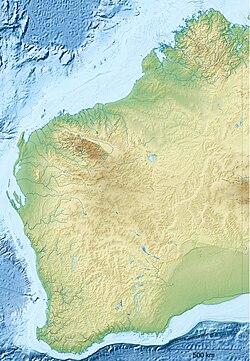
The headwaters of the river rise below Three Wells near Broomehill. The river flows in a south-westerly direction parallel with the Great Southern Highway as far as Tambellup then veers westward and crosses Albany Highway north of Cranbrook and discharges into the Frankland River of which it is a tributary.
The river flows through a number of pools during its journey, including Balbalingup Pool, Ballingup Pool, Boyacup Pool and Poolyup Pool.
The river has four tributaries: Wadjekanup River, Cowenup Brook, Slab Hut Gully and Uannup Brook.
The river was named in 1835 by Surveyor General John Septimus Roe during an expedition from Perth to Albany. The river is named after George Hamilton Gordon, the 4th Earl of Aberdeen, who later became the Prime Minister of the United Kingdom. [1]
The Mohawk River is a 149-mile-long (240 km) river in the U.S. state of New York. It is the largest tributary of the Hudson River. The Mohawk flows into the Hudson in Cohoes, New York, a few miles north of the city of Albany. The river is named for the Mohawk Nation of the Iroquois Confederacy. It is a major waterway in north-central New York. The largest tributary, the Schoharie Creek, accounts for over one quarter (26.83%) of the Mohawk River's watershed. Another main tributary is the West Canada Creek, which makes up for 16.33% of the Mohawk's watershed.
Albany Highway links Western Australia's capital city Perth with its oldest settlement, Albany, on the state's south coast. The 405-kilometre-long (252 mi) highway travels through the southern Wheatbelt and Great Southern regions, and is designated State Route 30 for most of its length. Outside of Perth the highway is predominately a sealed, single carriageway with regular overtaking lanes in some undulating areas. Albany Highway commences at The Causeway, a river crossing that connects to Perth's central business district. The highway heads south-east through Perth's metropolitan region, bypassed in part by Shepperton Road and Kenwick Link, and continues south-eastwards through to Albany. It intersects several major roads in Perth, including the Leach, Tonkin, Brookton, and South Western highways. The rural section of Albany Highway connects to important regional roads at the few towns and roadhouses along the route, including Coalfields Highway at Arthur River, Great Southern Highway at Cranbrook, and Muirs Highway at Mount Barker.
The Murchison River is the second longest river in Western Australia. It flows for about 820 km (510 mi) from the southern edge of the Robinson Ranges to the Indian Ocean at Kalbarri. The Murchison-Yalgar-Hope river system is the longest river system in Western Australia. It has a mean annual flow of 208 gigalitres, although in 2006, the peak year on record since 1967, flow was 1,806 gigalitres.
The Gascoyne River is a river in the Gascoyne region of Western Australia. At 865 kilometres (537 mi), it is the longest river in Western Australia.
The Serpentine River is a river in the South West region of Western Australia.
The Kalgan River is a river in the Great Southern region of Western Australia.
The King River is a river in the Great Southern region of Western Australia.
Deep River is a river located in the Great Southern region of Western Australia.
Balgarup River is a river in Western Australia that has its headwaters south-east of Kojonup just below Byenup Hill.
Gairdner River is a river located in the Great Southern region of Western Australia.
The Fortescue River is an ephemeral river in the Pilbara region of Western Australia. It is the third longest river in the state.
The Kent River is a river in the Great Southern of Western Australia.
The Warren River is a river in the South West region of Western Australia with a catchment encompassing the towns of Manjimup and Pemberton. The river was named by Governor James Stirling, probably after Admiral Sir John Borlase Warren under whom Stirling served whilst in action in North America in 1813.
The Maitland River is a river in the Pilbara region of Western Australia.
The Nullagine River is a river in the Pilbara region of Western Australia.
The Bowes River is a river in the Mid West of Western Australia. It was named on 6 April 1839 by the explorer George Grey while on his second exploration expedition along the Western Australian coast. It was named for Mary Bowes, Dowager Countess of Strathmore, the wife of Sir William Hutt. Hutt was a British Liberal politician who was heavily involved in the colonization of New Zealand and South Australia, and the brother of John Hutt, the second governor of Western Australia. Sir William Hutt was a member of the 1836 select committee on Disposal of Lands in the British Colonies. Grey named the nearby Hutt River after Hutt.
The Brockman River is a perennial river located in the Wheatbelt region of Western Australia.
The Mackie River is a river in the Wheatbelt region of Western Australia. The river is ephemeral and flows following winter and spring rains. The water discharged is saline.
Tourist Drives in Western Australia are routes through areas of scenic or historic significance, designated by route markers with white numbers on a brown shield. Tourist Drives were introduced into Western Australia while Eric Charlton was the state government Minister for Transport in the 1990s. The 28 numbered routes collectively traverse more than 2,000 kilometres (1,200 mi) across the state. In addition to the Tourist Drives, there are unnumbered routes such as the Golden Pipeline Heritage Trail, and local governments may designate and maintain local scenic drives, generally unnamed and unnumbered.
Ellen Brook is an ephemeral stream which runs from south of Gingin to the Swan River in Western Australia.