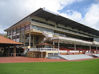
Ascot Racecourse is the major racecourse in Perth, Western Australia, situated approximately 8 kilometres (5.0 mi) east of the Perth central business district, with the headquarters of the Perth Racing positioned directly opposite.
The Austin expedition of 1854 was an expedition of exploration undertaken in Western Australia by Robert Austin in 1854. Members of Austin's party comprised John Hardey, Kenneth Brown, James Tatton Brockman Fraser (artist), Thomas Whitfield, James Guerin, Richard Buck, J. Edwards, W. Cant, Charles Farmer, and J. Woodward; and aboriginals Narryer, Wambinning, Wooddang and Souper.

Glen Forrest is a suburb within the Shire of Mundaring, south of John Forrest National Park, west of Mahogany Creek, east of Darlington, and north of the Helena River. Its northern boundary is determined by the Great Eastern Highway.

Francis Thomas "Frank" Gregory was an Australian explorer and politician.

Belmont is a suburb of Perth, the capital city of Western Australia, and is located 7 kilometres (4 mi) east of Perth's central business district on the southern bank of the Swan River. Its local government area is the City of Belmont.

The Hotham River is one of the major tributaries of the Murray River in Western Australia. It is about 160 kilometres (99 mi) long with its upper reaches being the Hotham River North, which begins in the Dutarning Range and joins the Hotham at its crossing of the Great Southern Highway near Popanyinning. A 15 km (9.3 mi) long southern tributary, Hotham River South, begins near Cuballing and flows generally northerly before joining the Hotham near Yornaning.

Tranby (Peninsula Farm) is an historic farmers cottage located on Johnson Road in Maylands overlooking the Swan River opposite Kuljak Island, and is one of the oldest surviving buildings from the early settlement of the Swan River Colony. It is described as an English cottage-style farmhouse with loft bedrooms and wide verandahs and is associated with a group of devout Wesleyan Methodists, led by Joseph Hardey and other members of his family, who arrived in Western Australia on the ship Tranby in February 1830.

Wesley Church is a Uniting Church in Perth, Western Australia, located at the corner of William Street and Hay Street. It is one of the oldest church buildings and one of few remaining 19th-century colonial buildings in the City of Perth.

The Fortescue River is an ephemeral river in the Pilbara region of Western Australia. It is the third longest river in the state.
The Impey River is a river in the Mid West region of Western Australia which rises south of Mount Murchison and flows east-north-east until it merges with the Murchison River of which it is a tributary.
The Kent River is a river in the Great Southern of Western Australia.
The Beasley River is a river in the Pilbara region of Western Australia.
The Maitland River is a river in the Pilbara region of Western Australia.

Peppermint Grove Beach is a residential subdivision and beachside town in the South West region of Western Australia. Its local government area is the Shire of Capel and it is located 8 kilometres (5 mi) northwest of Capel on the Geographe Bay coast near the Capel River mouth.
The Mackie River is a river in the Wheatbelt region of Western Australia. The river is ephemeral and flows following winter and spring rains. The water discharged is saline.
Wyloo Station, often referred to as Wyloo and previously known as Peake, is a pastoral lease that operates as a sheep station and cattle station.
Michael Clarkson was one of the early settlers in colonial Western Australia and in particular the Avon region.
Worsley River is a river in the South West region of Western Australia. The river rises in the Darling Range 2 kilometres (1.2 mi) south of the old timber town of Worsley then flows east and south discharging into the Collie River in Wellington Reservoir.
Coongan Station is a pastoral lease that was once a sheep station but now operates as a cattle station in Western Australia.
