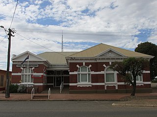
Esperance Plains, also known as Eyre Botanical District, is a biogeographic region in southern Western Australia on the south coast between the Avon Wheatbelt and Hampton bioregions, and bordered to the north by the Mallee region. It is a plain punctuated by granite and quartz outcrops and ranges, with a semi-arid Mediterranean climate and vegetation consisting mostly of mallee-heath and proteaceous scrub. About half of the region has been cleared for intensive agriculture. Recognised as a bioregion under the Interim Biogeographic Regionalisation for Australia (IBRA), it was first defined by John Stanley Beard in 1980.

The Shire of Ravensthorpe is a local government area in the southern Goldfields-Esperance region of Western Australia, about halfway between the city of Albany and the town of Esperance and about 530 kilometres (329 mi) southeast of the state capital, Perth. The Shire covers an area of 13,551 square kilometres (5,232 sq mi), and its seat of government is the town of Ravensthorpe.

Lennard River is a river in the Kimberley region of Western Australia. The river was named on 8 June 1879 by the explorer Alexander Forrest, during an expedition in the Kimberley area, after Amy Eliza Barrett-Lennard (1852-1897), who he was to marry on 15 January 1880.
The Oldfield River is an ephemeral river in the Goldfields-Esperance region of Western Australia that rises 95 kilometres (59 mi) inland from the South Coast at the edge of the Yilgarn plateau. The river starts at 300 metres (984 ft) above sea level then flows in a south easterly direction crossing the South Coast Highway near Munglinup.
Lort River is a river in the Goldfields-Esperance region and the Eastern Mallee sub-region of Western Australia.
Jerdacuttup River is a river located in the Goldfields-Esperance region of Western Australia. The water in the river is naturally saline.

The Margaret River is a river in the Kimberley region of Western Australia.
The Forrest River is a river in the Kimberley region of Western Australia.
The Fraser River is a river in the Kimberley region of Western Australia.
The Munglinup River is an ephemeral river in the Goldfields-Esperance region of Western Australia.
The Phillips River is an ephemeral river in the Goldfields-Esperance region of Western Australia.
The Steere River is a river in the Goldfields-Esperance region of Western Australia.
The Coongan River is an ephemeral river in the Pilbara region of Western Australia.
The Hamersley River is an ephemeral river in the Great Southern region of Western Australia.
The Behn River or Behm River is a river in the Kimberley region of Western Australia.

Neridup Land District is a land district of Western Australia, located within the Eucla Land Division on the state's south coast. It spans roughly 33°15'S - 34°00'S in latitude and 122°20'E - 123°30'E in longitude.

Esperance Land District is a land district of Western Australia, located within the Eucla Land Division on the state's south coast. It spans roughly 33°15'S - 34°00'S in latitude and 121°00'E - 122°20'E in longitude.
Fraser Range Station is a pastoral lease and sheep station located about 100 kilometres (62 mi) east of Norseman on the Eyre Highway in the Goldfields-Esperance region of Western Australia.
Sanko Harvest was a 32,502 DWT dry bulk carrier that sank off Esperance, Western Australia after striking a charted reef on 14 February 1991. The Korean-crewed Japanese-owned ship was 174 metres (571 ft) long and was carrying a cargo of 32,790 tonnes of phosphate fertilizer valued at A$8.9 million. Also on board were 677 tonnes of heavy bunker fuel and 40 tonnes of light diesel oil.
Esperance Stonehenge is a full-sized replica of Stonehenge, in Esperance, Western Australia. It was built from 137 locally quarried stones of up to 50 tonnes, and is aligned to the summer and winter solstices. It is designed to be a copy of the original, intact Stonehenge from c. 2000 BC, rather than the currently extant ruins.


