
Karlamilyi National Park lies in the Pilbara region of Western Australia, 250 kilometres (160 mi) northeast of Newman and 1,250 kilometres (780 mi) north-northeast of Perth. Proclaimed an A Class Reserve on 13 April 1977, it is the largest national park in Western Australia.
The Kimberley is the northernmost of the nine regions of Western Australia. It is bordered on the west by the Indian Ocean, on the north by the Timor Sea, on the south by the Great Sandy and Tanami deserts in the region of the Pilbara, and on the east by the Northern Territory.
The Gascoyne region is one of the nine regions of Western Australia. It is located in the northwest of Western Australia, and consists of the local government areas of Carnarvon, Exmouth, Shark Bay and Upper Gascoyne. The Gascoyne has about 600 km (370 mi) of Indian Ocean coastline; extends inland about 500 km (310 mi); and has an area of 135,073.8 km2 (52,152.3 sq mi), including islands.

The Murchison River is the second longest river in Western Australia. It flows for about 820 km (510 mi) from the southern edge of the Robinson Ranges to the Indian Ocean at Kalbarri. The Murchison-Yalgar-Hope river system is the longest river system in Western Australia. It has a mean annual flow of 208 gigalitres, although in 2006, the peak year on record since 1967, flow was 1,806 gigalitres.

Eneabba is a town on the Brand Highway 278 kilometres (173 mi) north of Perth, Western Australia.
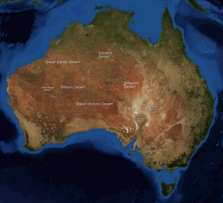
The deserts of Australia or the Australian deserts cover about 1,371,000 km2 (529,000 sq mi), or 18% of the Australian mainland, but about 35% of the Australian continent receives so little rain, it is practically desert. Collectively known as the Great Australian desert, they are primarily distributed throughout the Western Plateau and interior lowlands of the country, covering areas from South West Queensland, Far West region of New South Wales, Sunraysia in Victoria and Spencer Gulf in South Australia to the Barkly Tableland in Northern Territory and the Kimberley region in Western Australia.

The Gascoyne River is a river in the Gascoyne region of Western Australia. At 865 kilometres (537 mi), it is the longest river in Western Australia.
The Greenough River is a river in the Mid West region of Western Australia.
The De Grey River is a river located in the Pilbara region of Western Australia. It was named on 16 August 1861 by the explorer and surveyor Francis Gregory after Thomas de Grey, 2nd Earl de Grey, who was at the time the president of the Royal Geographical Society.
Hill River is a river in the Wheatbelt region of Western Australia.

Chapman River is a river in the Mid West region of Western Australia.
The Arrowsmith River lies within the Mid West region of Western Australia.
Hutt River is a river in the Mid West region of Western Australia.
The Bowes River is a river in the Mid West region of Western Australia. It was named on 6 April 1839 by the explorer George Grey while on his second exploration expedition along the Western Australian coast. It was named for Mary Bowes, Dowager Countess of Strathmore, the wife of Sir William Hutt. Hutt was a British Liberal politician who was heavily involved in the colonization of New Zealand and South Australia, and the brother of John Hutt, the second governor of Western Australia. Sir William Hutt was a member of the 1836 select committee on Disposal of Lands in the British Colonies. Grey named the nearby Hutt River after Hutt.
The Nambung River is a river in the Wheatbelt region of Western Australia, 170 kilometres (106 mi) north of Perth. The river drains an area between the towns of Cervantes and Badgingarra. In its lower reaches the Nambung River forms a chain of waterholes in the Nambung Wetlands where it disappears underground into a limestone karst system 5.5 kilometres (3 mi) from the Indian Ocean.
De Grey Station is a pastoral lease, formerly a sheep station and now a cattle station, approximately 80 kilometres (50 mi) east of Port Hedland on the mouth of the De Grey River in the Pilbara region of Western Australia.

South West Queensland is a remote region in the Australian state of Queensland which covers 319,808 km2 (123,479 sq mi). The region lies to the south of Central West Queensland and west of the Darling Downs and includes the Maranoa district and parts of the Channel Country. The area is noted for its cattle grazing, cotton farming, opal mining and oil and gas deposits.
The Buller River is a river in the Mid West region of Western Australia, near Geraldton.
The Gairdner River is located in the Kimberley region of Western Australia. The river is located in the west Kimberley, and is a 42 km long tributary of the Glenelg River.
Yeeda Station is a pastoral lease that operates as a cattle station in the Kimberley region of Western Australia.

