| Brockman | |
|---|---|
| Etymology | William Locke Brockman, a pastoralist |
| Location | |
| Country | Australia |
| State | Western Australia |
| Region | Wheatbelt |
| Physical characteristics | |
| Source | Darling Scarp |
| • location | north of Bindoon Hill |
| • coordinates | 31°14′13″S116°4′8″E / 31.23694°S 116.06889°E |
| • elevation | 159 m (522 ft) |
| Mouth | Avon River |
• location | east of Bullsbrook |
• coordinates | 31°41′1″S116°7′6″E / 31.68361°S 116.11833°E |
• elevation | 55 m (180 ft) |
| Length | 73 km (45 mi) |
| Basin size | 1,520 km2 (590 sq mi) |
| Basin features | |
| River system | Avon River |
| [1] [2] | |
The Brockman River is a perennial river located in the Wheatbelt region of Western Australia.
The river rises north of Bindoon Hill and then flows generally in a southerly direction. The river is crossed by the Great Northern Highway near the Bindoon-Moora Road turnoff and flows parallel with the highway as it continues southward. Passing the town of Bindoon and through Lake Needoonga and Lake Chittering, the highway crosses the river as the river veers eastward. The river then passes Lower Chittering and finally discharges into the Avon River near Jumperkine Hill just north of Walyunga National Park. The river has many smaller tributaries including Wootra Brook, Spice Brook, Longbridge Gully, Marbling Brook, and Marda Brook. The river descends 103 metres (338 ft) over its 73-kilometre (45 mi) course. [1]
The Brockman has the largest catchment in the Lower Avon and Upper Swan River catchments. The natural resource base of the river is deteriorating as a result of clearing of natural vegetation which in turn has led to erosion and salinity.
The first European to pass by the river was the surveyor Francis Thomas Gregory who named the river in 1853. The river is named after William Locke Brockman who was a pastoralist in the region with large land holdings and a Member of the Western Australian Legislative Council. [3]

The Swan River is a major river in the southwest of Western Australia. The river runs through the metropolitan area of Perth, Western Australia's capital and largest city.

The Avon River is a river in Western Australia. A tributary of the Swan River, the Avon flows 240 kilometres (150 mi) from source to mouth, with a catchment area of 125,000 square kilometres (48,000 sq mi).

Toodyay, known as Newcastle between 1860 and 1910, is a town on the Avon River in the Wheatbelt region of Western Australia, 85 kilometres (53 mi) north-east of Perth. The first European settlement occurred in the area in 1836. After flooding in the 1850s, the townsite was moved to its current location in the 1860s. It is connected by railway and road to Perth. During the 1860s, it was home to bushranger Moondyne Joe.

The Shire of Chittering is a local government area in the Wheatbelt region of Western Australia, covering an area of about 1,200 square kilometres (460 sq mi) just beyond the northeastern fringe of the Perth metropolitan area, generally along and east of the Great Northern Highway. Its seat of government is the town of Bindoon.

Great Northern Highway is an Australian highway that links Western Australia's capital city Perth with its northernmost port, Wyndham. With a length of almost 3,200 kilometres (2,000 mi), it is the longest highway in Australia, with the majority included as part of the Perth Darwin National Highway. The highway is constructed as a sealed, predominantly two-lane single carriageway, but with some single-lane bridges in the Kimberley. The Great Northern Highway travels through remote areas of the state, and is the only sealed road link between the Northern Territory and northern Western Australia. Economically, it provides vital access through the Wheatbelt and Mid West to the resource-rich regions of the Pilbara and Kimberley. In these areas, the key industries of mining, agriculture and pastoral stations, and tourism are all dependent on the highway.

The Helena River is a tributary of the Swan River in Western Australia. The river rises in country east of Mount Dale and flows north-west to Mundaring Weir, where it is dammed. It then flows west until it reaches the Darling Scarp.
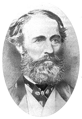
William Locke Brockman was an early settler in Western Australia, who became a pastoralist and stock breeder, and a Member of the Western Australian Legislative Council.
Bindoon is a town 84 kilometres (52 mi) from Perth city on the Great Northern Highway within the Shire of Chittering. The name Bindoon is thought to be Aboriginal in origin and to mean "place where the yams grow". The name has been in use in the area since 1843 when an early settler, William Brockman, named the property he had surveyed as Bindoon. The townsite was gazetted in 1953.

The Capel River is a river in the South West region of Western Australia that rises in the Darling Range east of Mullalyup, and flows into the Indian Ocean at Peppermint Grove Beach.

The Fortescue River is an ephemeral river in the Pilbara region of Western Australia. It is the third longest river in the state.
The Warren River is a river in the South West region of Western Australia with a catchment encompassing the towns of Manjimup and Pemberton. The river was named by Governor James Stirling, probably after Admiral Sir John Borlase Warren under whom Stirling served whilst in action in North America in 1813.
The Mortlock River is a perennial river located in the Wheatbelt region of Western Australia.
The Minilya River is a river in the Gascoyne region of Western Australia.
Lockhart River is a river in the Wheatbelt region of Western Australia. It is a sub-catchment of the Avon River, and has an area of 32,400 square kilometres (12,500 sq mi). At its junction with the Yilgarn River to form the Salt River, it passes through a hydrological-topographical pinch-point at 'Caroline Gap'.

The River Isbourne is 14 mile (22 km) long tributary of the River Avon which flows through Gloucestershire and Worcestershire in the Midlands of England.
Tourist Drives in Western Australia are routes through areas of scenic or historic significance, designated by route markers with white numbers on a brown shield. Tourist Drives were introduced into Western Australia while Eric Charlton was the state government Minister for Transport in the 1990s. The 28 numbered routes collectively traverse more than 2,000 kilometres (1,200 mi) across the state. In addition to the Tourist Drives, there are unnumbered routes such as the Golden Pipeline Heritage Trail, and local governments may designate and maintain local scenic drives, generally unnamed and unnumbered.

Highways and main roads in the Wheatbelt region of Western Australia form the basis of a road network, which is primarily used by the mining, agriculture, and tourism industries. Main Roads Western Australia maintains and controls these major roads, with offices based in Northam and Narrogin.

The Campaspe River, an inland intermittent river of the north–central catchment, part of the Murray-Darling basin, is located in the lower Riverina bioregion and Central Highlands and Wimmera regions of the Australian state of Victoria. The headwaters of the Campaspe River rise on the northern slopes of the Great Dividing Range and descend to flow north into the Murray River, Australia's longest river, near Echuca.

Ellen Brook is an ephemeral stream which runs from south of Gingin to the Swan River in Western Australia.
Yilgarn River is a river in the eastern Wheatbelt region of Western Australia. It is a sub-catchment of the Avon River, and has an area of 55,900 square kilometres (21,600 sq mi). At its junction with Lockhart River, their combined flow passes through a hydrological-topographical pinch-point at Caroline Gap, a geomorphic saddle between Mt Caroline and Mt Stirling.
Rivers of Western Australia | |
|---|---|
| Rivers of the Gascoyne region | |
| Rivers of the Goldfields-Esperance region | |
| Rivers of the Great Southern region | |
| Rivers of the Kimberley region |
|
| Rivers of the Mid West region | |
| Rivers of the Peel and Perth regions | |
| Rivers of the Pilbara region | |
| Rivers of the South West region | |
| Rivers of the Wheatbelt region | |