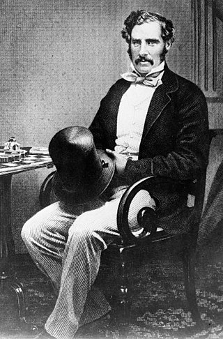
Sir George Grey, KCB was a British soldier, explorer, colonial administrator and writer. He served in a succession of governing positions: Governor of South Australia, twice Governor of New Zealand, Governor of Cape Colony, and the 11th premier of New Zealand. He played a key role in the colonisation of New Zealand, and both the purchase and annexation of Māori land.
Sir William Hutt, KCB, PC was a British Liberal politician who was heavily involved in the colonisation of New Zealand and South Australia.

North West Coastal Highway is a generally north-south Western Australian highway which links the coastal city of Geraldton with the town of Port Hedland. The 1,300-kilometre-long (808 mi) road, constructed as a sealed two-lane single carriageway, travels through remote and largely arid landscapes. Carnarvon is the only large settlement on the highway, and is an oasis within the harsh surrounding environment. The entire highway is allocated National Route 1, part of Australia's Highway 1, and parts of the highway are included in tourist routes Batavia Coast Tourist Way and Cossack Tourist Way. Economically, North West Coastal Highway is an important link to the Mid West, Gascoyne and Pilbara regions, supporting the agricultural, pastoral, fishing, and tourism industries, as well as mining and offshore oil and gas production.

Northampton is a town 52 kilometres (32 mi) north of Geraldton, in the Mid West region of Western Australia. At the 2011 census, the town had a population of 868. The town contains a National Trust building. The town lies on the North West Coastal Highway. Originally called The Mines, Northampton was gazetted in 1864 and named after the colony's Governor, John Hampton. The town was sited in the Nokanena Brook valley, between the hamlets around the two major copper mines in the area, the Wanerenooka and the Gwalla.

The Murchison River is the second longest river in Western Australia. It flows for about 820 km (510 mi) from the southern edge of the Robinson Ranges to the Indian Ocean at Kalbarri. The Murchison-Yalgar-Hope river system is the longest river system in Western Australia. It has a mean annual flow of 208 gigalitres, although in 2006, the peak year on record since 1967, flow was 1,806 gigalitres.
Moore River (Garban) is a river in the Wheatbelt region of Western Australia.
The Greenough River is a river in the Mid West region of Western Australia.
The De Grey River is a river located in the Pilbara region of Western Australia. It was named on 16 August 1861 by the explorer and surveyor Francis Gregory after Thomas de Grey, 2nd Earl de Grey, who was at the time the president of the Royal Geographical Society.
Hill River is a river in the Wheatbelt region of Western Australia.

The Shire of Northampton is a local government area in the Mid West region of Western Australia, about 50 kilometres (30 mi) north of Geraldton and about 460 kilometres (290 mi) north of the state capital, Perth. The Shire covers an area of 13,738 square kilometres (5,304 sq mi), and its seat of government is the town of Northampton, with the largest settlement being Kalbarri.

Chapman River is a river in the Mid West region of Western Australia.
The Arrowsmith River lies within the Mid West region of Western Australia.

The Irwin River is a river in the Mid West region of Western Australia. It was named on 9 April 1839 by the explorer George Grey, while on his second disastrous exploration expedition along the Western Australian coast, after his friend Major Frederick Irwin, the Commandant of the Swan River settlement.
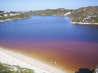
Hutt River is a river in the Mid West region of Western Australia.
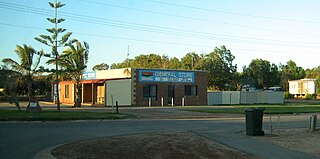
Gregory is a small town and fishing port located 7 km (4.3 mi) northwest of the mouth of the Hutt River, in the Mid West region of Western Australia. At the 2016 census, Gregory had a population of 64 in 83 dwellings. Most of the dwellings are holiday houses. The population of Gregory fluctuates depending on tourism; with the town at full capacity during school holidays and throughout the summer. During the census 50% of dwellings were unoccupied.

Hutt Lagoon is a marine salt lake located near the Indian Ocean coast 2 kilometres (1.2 mi) north of the mouth of the Hutt River, in the Mid West region of Western Australia.
Grey's Spring, sometimes called Grey's Well, is a historical site in Kalbarri, Western Australia. It is a stone-lined well dating from after 1848, named after Lieutenant George Grey whose boats were wrecked in the surf of Gantheaume Bay on 1 April 1839, during his second disastrous exploration expedition along the Western Australian coast. It has a grid cover installed for safety reasons, and a commemorative plaque. It is located in Kalbarri Lions Park, Walker Street, Kalbarri.

The Margaret River is a river in the Kimberley region of Western Australia.
The Gordon River is a river in the Great Southern region of Western Australia.
The Buller River is a river in the Mid West region of Western Australia, near Geraldton.
