Hay River (Western Australia)

Last updated

Hay River
Hayriverwa.jpg
Hay River flowing into Wilson Inlet
Location
CountryAustralia
Physical characteristics
Source 
  locationWest of Mount Barker
  elevation225 metres (738 ft) [1]
Mouth  
  location
Wilson Inlet
  elevation
sea level
Length80 kilometres (50 mi) [2]
Basin size129,800 hectares (320,743 acres)
Discharge 
  average69,400 ML/a (2.20 m3/s; 77.7 cu ft/s)

The Hay River is a river in the Great Southern region of Western Australia. The traditional owners of the area are the Noongar people, who know the river as Genulup. [3]

The river was given its English name in December 1829 by naval ship's surgeon Thomas Braidwood Wilson after Sir Robert William Hay, Permanent Under-secretary of State for the Colonies from 1825 to 1836. Wilson saw the river while exploring the area in company with the Noongar man Mokare, John Kent (officer in charge of the Commissariat at King George Sound), two convicts and Private William Gough of the 39th Regiment, while his ship Governor Phillip was being repaired at King George Sound. [4]

The Hay River is part of the Denmark catchment, which comprises Wilson Inlet, Torbay Inlet and Lake Powell, together with the catchments of the Denmark, Hay and Sleeman-Cuppup Rivers and their tributaries. [5]

The river rises west of Mount Barker near Wilpuna Park and flows south east as far as Ungerup then flows in a south-south-westerly direction through the Mount Lindesay National Park then crosses the South Coast Highway and discharges into Wilson Inlet. [6]

The tidal influence is 5 kilometres (3 mi) upstream from where the river flows into the inlet. The Hay River flows all year and the water quality is marginally saline to brackish. It is estimated that 70% of the catchment area has been cleared for agricultural purposes but 42% of the riparian zone was pristine.

Tributaries of the river include Sleeman Creek and Mitchell River.

Related Research Articles

<span class="mw-page-title-main">Moruya River</span> River in New South Wales, Australia

The Moruya River is an open and trained mature wave dominated barrier estuary or tidal river is located in the South Coast region of New South Wales, Australia. In its upper freshwater reaches, the river is known as the Deua River.

<span class="mw-page-title-main">Torbay, Western Australia</span> Town in Western Australia

Torbay is a small town and a bay in the Great Southern region of Western Australia, 20 kilometres (12 mi) west of Albany. Torbay is within the City of Albany local government area. The Torbay townsite was gazetted in 1910.

<span class="mw-page-title-main">Mount Barker, Western Australia</span> Town in Western Australia

Mount Barker is a town on Albany Highway and the administrative centre of the Shire of Plantagenet in the Great Southern region of Western Australia. At the 2021 census, Mount Barker had a population of 2,855.

<span class="mw-page-title-main">King George Sound (Western Australia)</span> Large body of water in southern Western Australia

King George Sound is a sound on the south coast of Western Australia. Named King George the Third's Sound in 1791, it was referred to as King George's Sound from 1805. The name "King George Sound" gradually came into use from about 1934, prompted by new Admiralty charts supporting the intention to eliminate the possessive 's' from geographical names.

<span class="mw-page-title-main">Manning River</span> River in New South Wales, Australia

Manning River, an open and trained mature wave dominated barrier estuary, is located in the Northern Tablelands and Mid North Coast districts of New South Wales, Australia. It is the only double delta river in the southern hemisphere in which there are two permanent entrances to the river, one at Old Bar and another at Harrington, and is famously one of only two rivers in the world to have permanent multiple entrances with the other being the Nile river in Egypt.

<span class="mw-page-title-main">Denmark, Western Australia</span> Coastal town in Western Australia

Denmark is a coastal town located on Wilson Inlet in the Great Southern region of Western Australia, 423 kilometres (263 mi) south-south-east of the state capital of Perth. At the 2016 census, Denmark had a population of 2,558; however, the population can be several times the base population during tourist seasons.

<span class="mw-page-title-main">Blackwood River</span> River in Western Australia

The Blackwood River is a major river and catchment in the South West of Western Australia.

<span class="mw-page-title-main">Thomas Braidwood Wilson</span> Australian surgeon and explorer (1792–1843)

Thomas Braidwood Wilson FRGS was an Australian surgeon and explorer. He was baptised in Kirknewton, West Lothian, Scotland, the son of James, and Catherine Boak.

<span class="mw-page-title-main">Murray River (Western Australia)</span> River in Peel region of Western Australia

The Murray River is a river in the southwest of Western Australia. It played a significant part in the expansion of settlement in the area south of Perth after the arrival of British settlers at the Swan River Colony in 1829. It should not be confused with the Murray River in southeastern Australia, which is the longest river in the country.

<span class="mw-page-title-main">Kalgan River</span> River in Western Australia

The Kalgan River is a river in the Great Southern region of Western Australia.

<span class="mw-page-title-main">King River (Great Southern, Western Australia)</span> River in Western Australia

The King River is a river in the Great Southern region of Western Australia.

<span class="mw-page-title-main">Mokare</span>

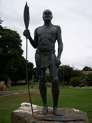
Mokare was a Noongar Aboriginal man from the south-west corner of Australia, who was pivotal in aiding European exploration of the area.

<span class="mw-page-title-main">Frankland River (Western Australia)</span> River in Western Australia

The Frankland River is a river in the Great Southern region of Western Australia. The Frankland River is the largest river by volume in the region and the eighth largest in the state. The traditional owners of the area are the Menang Noongar people, who know the river as Kwakoorillup, meaning "place of quokka".

<span class="mw-page-title-main">Fitzgerald River</span> River in Western Australia

The Fitzgerald River is a river in the Great Southern region of Western Australia.

<span class="mw-page-title-main">Denmark River</span> River in Western Australia

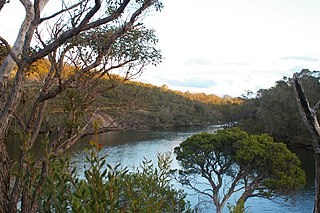
The Denmark River is located in the Great Southern region of Western Australia. The river rises near Pardelup and meanders in a southerly direction until it flows through Denmark into Wilson Inlet. The traditional owners of the area are the Noongar people, who know the river as Kwoorabup, meaning the place of the Western brush wallaby.

<span class="mw-page-title-main">Gairdner River (Great Southern, Western Australia)</span> River in Western Australia

Gairdner River is a river located in the Great Southern region of Western Australia.

Pallinup River is a river located in the Great Southern region of Western Australia. It was previously known as Salt River.

The Young River is a river on the South coast of Western Australia that rises south of the Frank Hann National Park then flows in a south easterly direction for a distance of 95 kilometres (59 mi) before flowing into Stokes Inlet which discharges into the Southern Ocean.

<span class="mw-page-title-main">Wilson Inlet</span> Inlet south of Denmark, Western Australia

Wilson Inlet is a shallow, seasonally open estuary located on the coast of the Great Southern region of Western Australia.

The Kent River is a river in the Great Southern of Western Australia.

References

  1. "Bonzle Digital Atlas – Map of Hay River, WA". 2008. Retrieved 12 July 2016.
  2. "South Coast River Care – Hay River". 2007. Retrieved 28 September 2007.[ permanent dead link ]
  3. "Dual Naming Project" (PDF). Shire of Denmark . Retrieved 3 June 2017.
  4. Wilson, Thomas Braidwood (1835). Narrative of a Voyage Round the World. London: Sherwood Gilbert & Piper. pp.  262.
  5. "South Coast River Care – Denmark Catchment". 2007. Retrieved 10 October 2010.
  6. "History of river names – H". Western Australian Land Information Authority. Archived from the original on 19 April 2021. Retrieved 4 August 2008.

34°58′19″S117°27′39″E / 34.97194°S 117.46083°E / -34.97194; 117.46083