Claise Brook

Last updated

Claise Brook, 1861 Claise Brook, 1861.JPG
Claise Brook, 1861
Claise Brook and Perth City skyline from the Perth City Stadium 2018 Perth city skyline and Claise Brook.jpg
Claise Brook and Perth City skyline from the Perth City Stadium 2018
External videos
Nuvola apps kaboodle.svg East Perth 1948–2010 Landgate Aerial Photography

Claise Brook is a stream which empties into Claisebrook Cove before running into the Swan River in Perth, Western Australia. The area surrounding the stream is on the outskirts of the Perth CBD and is part of the suburb of East Perth. Claise Brook was once an important water course from which the numerous interconnected fresh water lakes north of Perth emptied into during the wet season before entering the Swan River. [1]

Contents

History

Since the gradual resumption of land over the various feeder lakes, and more recently the East Perth redevelopment in the late 1980s, the stream has become a mainly underground catchment and drainage system and no longer exists as a stream in the normal sense.

The stream and cove were initially called Mandalup, meaning "place of the small marsupial". It was later named Clause's Brook and Clause's Lagoon respectively, however these names appear to have been dropped soon after European settlement: an 1851 newspaper report spoke of the establishment of an abattoir at "Claise Brook". [2] They were named after Frederick Clause who was a naval surgeon that accompanied Captain (later Admiral Sir) James Stirling in their expedition up the Swan River in March 1827. Botanist Charles Fraser who was on the same expedition described the lagoon in his journal: [3]

"One mile up the river from the last point is a small creek of fresh water, issuing from an extensive lagoon clothed with arborescent species of Metrosideros of great beauty. The banks are covered with the most interesting plants, amongst which I observed two species of Calytris , a species of Acacia with a scolopendrous-stem, and several Papilionaceous plants. The Angophoras on the flats are gigantic."

Since the latter half of the 1800s until the mid-1980s, the area around Claise Brook and Claisebrook Cove was used for mainly industrial purposes and the water quality and surrounds were badly degraded. During this period it was also widely referred to as Claisebrook Drain. In the late 1800s and early 1900s it had become an effluent outlet into the river. [4] In 1906 the Claisebrook and Burswood Sewerage Treatment Works was built. [5] Sewerage was pumped across the river from Claise Brook to ponds and filter beds on Burswood Island.

East Perth Gasometer and East Perth Power Station were prominent structures there for many years during the 1900s, both on the northern side of the river outlet.

Prior to the redevelopment from the mid-1980s, a major environmental remediation project was undertaken to remove polycyclic aromatic hydrocarbon contaminated soils created by the East Perth Gas Works which operated there from 1922 to 1971. [6] The plant produced gas from coal. Remediation included dredging of six hectares (15 acres) of adjacent riverbeds and removal and treatment of 10,000 m3 (350,000 cu ft) of soil.

Redevelopment

Claisebrook Cove and Trafalgar Bridge with the Perth skyline in the background in January 2021 Claisebrook Cove, East Perth, January 2021 08.jpg
Claisebrook Cove and Trafalgar Bridge with the Perth skyline in the background in January 2021

The precinct surrounding the cove is now known as Claisebrook Village [7] and is now mainly residential. The cove is now a heavily landscaped artificial inlet of the Swan River overlooked by residential buildings and bars, cafes and restaurants. Facilities include moorings and jetties for recreational boating and Trafalgar Bridge which is a pedestrian footbridge which crosses the cove.

Crossing the river nearby is Matagarup Bridge, Goongoongup Railway Bridge and Windan Bridge which carries road traffic from the Graham Farmer Freeway.

Related Research Articles

<span class="mw-page-title-main">Swan River (Western Australia)</span> River in Perth, Western Australia

The Swan River is a major river in the southwest of Western Australia. The river runs through the metropolitan area of Perth, Western Australia's capital and largest city.

<span class="mw-page-title-main">Perth Water</span> Body of water of Swan River, Western Australia

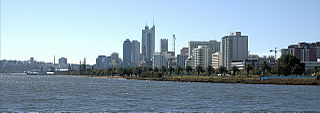
Perth Water is a section of the Swan River on the southern edge of the central business district of Perth, Western Australia. It is between the Causeway to the east, and Narrows Bridge to the west – a large wide but shallow section of river, and the northern edge of the suburb South Perth. It is considered a landmark of the City of Perth.

<span class="mw-page-title-main">Burswood, Western Australia</span> Suburb of Perth, Western Australia

Burswood is an inner southeastern suburb of Perth, Western Australia, located immediately across the Swan River from Perth's central business district (CBD). Its local government area is the Town of Victoria Park. Burswood is the location of the State Tennis Centre, Perth Stadium, Belmont Park Racecourse, and the Crown Perth casino and hotel complex.

<span class="mw-page-title-main">East Perth, Western Australia</span> Suburb of Perth, Western Australia

East Perth is an inner suburb of Perth, Western Australia, located next to the Perth central business district. Claise Brook and Claisebrook Cove are within the suburb. Formerly characterised by industrial land uses and urban blight, the redevelopment of East Perth was, and remains, the largest inner-city urban renewal project in the state. The design of the new residential neighbourhoods was strongly influenced by the new urbanism movement.

<span class="mw-page-title-main">Canning River</span> River in Perth, Western Australia

<span class="mw-page-title-main">Blackwood River</span> River in Western Australia

The Blackwood River is a major river and catchment in the South West of Western Australia.

Claisebrook is an area in the Central Business District of Perth, Western Australia, and may refer to:

<span class="mw-page-title-main">Frederick Clause</span>

Frederick Rushbrook Clause was a naval surgeon, an early explorer in Western Australia and an artist.

Charles Fraser or Frazer or Frazier was Colonial Botanist of New South Wales from 1821 to 1831. He collected and catalogued numerous Australian plant species, and participated in a number of exploring expeditions. He was a member of the Stirling expedition of 1827, and his report on the quality of the soil was instrumental in the decision to establish the Swan River Colony.

<span class="mw-page-title-main">Gloucester Park, Perth</span> Harness racing venue in Perth, Western Australia

Gloucester Park is a harness racing course in Perth, Western Australia. In the suburb of East Perth, the oval course is adjacent to the WACA Ground. The track is lit, and Friday night pacing events are popular. As of 2006 the Western Australian Trotting Association have used Gloucester Park for more than 70 years, starting with the first Inter Dominion Championship held in February 1936. Gloucester Park has also been used for Telstra Rally Australia. Between 1977 and 1979 Gloucester Park was used as a venue for World Series Cricket matches. Between September 2015 and April 2017, the drop-in wickets for Optus Stadium were built and maintained in the center of Gloucester Park.

<span class="mw-page-title-main">Melville Water</span> Section of river in Perth, Western Australia

The Public Works Department (PWD) was the State Government Agency of Western Australia, which was charged with providing and maintaining public infrastructure such as dams, water supplies, schools, hospitals, harbours and other public buildings. The department is no longer operational, having its responsibilities reassigned to other State Government Departments and corporate entities since 1985.

<span class="mw-page-title-main">Perth Stadium</span> Stadium in Perth, Western Australia

Perth Stadium, currently known as Optus Stadium for sponsorship reasons, is a multi-purpose stadium in Perth, Western Australia, located in the suburb of Burswood. It was completed in late 2017 and officially opened on 21 January 2018. The stadium's total capacity is 61,266, including standing room, making it the third-largest stadium in Australia. The stadium can be extended up to 65,000 seats for rectangular sports.

<i>Eliza</i> (sculpture) Sculpture located in the Swan River, Western Australia

Eliza is a bronze sculpture located in Matilda Bay on the Swan River in Western Australia. The sculpture and plinth are mounted on a steel pylon 15 metres (49 ft) off the shoreline and depicts a woman about to dive off a wooden platform. It commemorates the old Crawley Baths which were a prominent Perth landmark during the early to mid 20th century. The sculpture is 2.2 metres high. The artwork has its own lighting from solar panels.

<span class="mw-page-title-main">Perth Wetlands</span> Bodies of water on Swan Coastal Plain

The Perth Wetlands, also known as the Perth Great Lakes or the Great Lakes District, was a collection of fresh-water wetlands, swamps and lakes located on the Swan Coastal Plain north of the city of Perth in Western Australia. Over a period of 80 years from the first British settlement in Western Australia in 1829 most of the wetlands were reclaimed for use as housing, parks and market gardens.

<span class="mw-page-title-main">Bunbury Bridge</span> Former railway bridge in East Perth, Western Australia

Bunbury Bridge was a single-track, timber railway bridge in East Perth in Western Australia. The bridge crossed the Swan River near Claise Brook and was built for passenger and freight traffic to Bunbury on the South Western Railway.

<span class="mw-page-title-main">East Perth Gas Works</span> Demolished gas works in East Perth, Western Australia

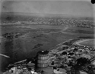
East Perth Gas Works was built in 1922 for the Perth City Council to produce town gas from coal, supplying the city of Perth in Western Australia. It could initially supply 28,000 cubic metres (1,000,000 cu ft) of gas per day.

<span class="mw-page-title-main">Goongoongup Bridge</span> Railway bridge in Perth, Western Australia

Goongoongup Bridge is a railway bridge in East Perth, Western Australia which crosses the Swan River and forms part of the Armadale line. It opened on 24 July 1995 as part of the electrification of Perth's suburban railway network. The name is derived from the Nyungar word for the Claisebrook area.

<span class="mw-page-title-main">Elizabeth Quay</span> Waterfront development of a precinct in Perth, Western Australia

Elizabeth Quay is a mixed-use development project in the Perth central business district. Encompassing an area located on the north shore of Perth Water near the landmark Swan Bells, the precinct was named in honour of Queen Elizabeth II during her Diamond Jubilee.

References

  1. Seddon, George (1972). Sense of Place. Nedlands: University of Western Australia Press. OCLC   35572047.
  2. "Domestic Sayings and Doings". The Perth Gazette and Independent Journal of Politics and News . National Library of Australia. 28 November 1851. p. 3. Retrieved 10 January 2012.
  3. Fraser, Charles (1827). The Visit of Charles Fraser to the Swan River in 1827.
  4. "The City sewerage". The West Australian . Perth: National Library of Australia. 4 June 1906. p. 2. Retrieved 8 January 2012.
  5. "Burswood Island filter beds, part of the Claisebrook and Burswood Sewerage Treatment Works [picture]". SLWA Online catalogue. Retrieved 8 January 2012.
  6. "Contamination Management Strategy for East Perth Gasworks Site" (PDF). Environmental Protection Authority of Western Australia. October 1992. Archived from the original (PDF) on 25 March 2012. Retrieved 7 April 2012.
  7. Metropolitan Redevelopment Authority

31°57′09″S115°52′38″E / 31.952527°S 115.877302°E / -31.952527; 115.877302 (Claise Brook)