
The Swan River is a major river in the southwest of Western Australia. The river runs through the metropolitan area of Perth, Western Australia's capital and largest city.

Great Eastern Highway is a 590-kilometre-long (370 mi) road that links the Western Australian capital of Perth with the city of Kalgoorlie. A key route for road vehicles accessing the eastern Wheatbelt and the Goldfields, it is the western portion of the main road link between Perth and the eastern states of Australia. The highway forms the majority of National Highway 94, although the alignment through the Perth suburbs of Guildford and Midland, and the eastern section between Coolgardie and Kalgoorlie are not included. Various segments form parts of other road routes, including National Route 1, Alternative National Route 94, and State Route 51.
The Kwinana Freeway is a 72-kilometre (45 mi) freeway in and beyond the southern suburbs of Perth, Western Australia, linking central Perth with Mandurah to the south. It is the central section of State Route 2, which continues north as Mitchell Freeway to Clarkson, and south as Forrest Highway towards Bunbury. A 4-kilometre (2.5 mi) section between Canning and Leach highways is also part of National Route 1. Along its route are interchanges with several major roads, including Roe Highway and Mandjoogoordap Drive. The northern terminus of the Kwinana Freeway is at the Narrows Bridge, which crosses the Swan River, and the southern terminus is at Pinjarra Road, east of Mandurah.
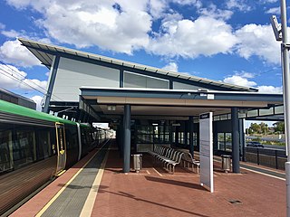
Clarkson railway station is a suburban rail station in Clarkson, a suburb of Perth, Western Australia. It is on the Yanchep line, which is part of the Transperth network. Located in the median of the Mitchell Freeway, the station consists of an island platform connected to the west by a pedestrian footbridge. A six-stand bus interchange and two carparks are located near the entrance.

Graham Farmer Freeway is a 6.4-kilometre (4.0 mi) inner-city freeway in Perth, Western Australia. It links Rivervale and Burswood with West Perth and Leederville, providing an east-west bypass of Perth's central business district.
The Mitchell Freeway is a 41.5-kilometre-long (25.8 mi) freeway in the northern suburbs of Perth, Western Australia, linking central Perth with the city of Joondalup. It is the northern section of State Route 2, which continues south as Kwinana Freeway and Forrest Highway. Along its length are interchanges with several major roads, including the Graham Farmer Freeway and Reid Highway. The southern terminus of the Mitchell Freeway is at the Narrows Bridge, which crosses the Swan River, and the northern terminus is at Romeo Road in Alkimos.
The Causeway is an arterial traffic crossing in Perth, Western Australia, linking the inner-city suburbs of East Perth and Victoria Park. It is carried over the Swan River at the eastern end of Perth Water by two bridges on either side of Heirisson Island. The current Causeway is the third structure to have been built across the river at this point.

Roe Highway is a 35-kilometre-long (22 mi) limited-access highway and partial freeway in Perth, Western Australia, linking Kewdale with the city's north-eastern and south-western suburbs. The northern terminus is at Reid Highway and Great Northern Highway in Middle Swan, and the southern terminus is with Murdoch Drive at the Kwinana Freeway interchange in Bibra Lake. Roe Highway, in addition to Reid Highway, form State Route 3, a partial ring road around the outer suburbs of the Perth metropolitan area. Roe Highway also forms part of National Highway 94 from Great Eastern Highway Bypass to Great Eastern Highway, and National Highway 95 from Great Eastern Highway to Great Northern Highway.

Reid Highway is a 23-kilometre (14 mi) east-west highway and partial freeway in the northern suburbs of Perth, Western Australia, linking North Beach with Middle Swan. As part of State Route 3, it forms half of Perth's outer ring road along with Roe Highway, which it joins onto at its eastern terminus.
Tonkin Highway is an 81-kilometre-long (50 mi) north–south highway and partial freeway in Perth, Western Australia, linking Perth Airport and Kewdale with the city's north-eastern and south-eastern suburbs. As of April 2020, the northern terminus is at the interchange with Brand Highway and Great Northern Highway in Muchea, and the southern terminus is at Thomas Road in Oakford. It forms the entire length of State Route 4, and connects to several major roads. Besides Brand Highway and Great Northern Highway, it also connects to Reid Highway, Great Eastern Highway, Leach Highway, Roe Highway, and Albany Highway.
Transport in Perth, Western Australia, is served by various means, among them an extensive highway/freeway network and a substantial system of commuter rail lines and bus routes. Public transport is managed by the Transperth agency.
Thiess Pty Ltd is an international mining services company based in Brisbane, Australia. Established in the 1930s as Horn & Thiess, the company later became Thiess Bros and Thiess Contractors before being bought by Leighton Holdings in 1983 to become part of the CIMIC Group. Thiess' headquarters are located in the Thiess Centre in South Bank in the Brisbane CBD near the TAFE Brisbane City campus.

Cycling in Perth, Western Australia is common on the roads and paths for recreation, commuting and sport. Between 1998 and 2009 the number of cyclists in Perth increased 450%.

Claise Brook is a stream which empties into Claisebrook Cove before running into the Swan River in Perth, Western Australia. The area surrounding the stream is on the outskirts of the Perth CBD and is part of the suburb of East Perth. Claise Brook was once an important water course from which the numerous interconnected fresh water lakes north of Perth emptied into during the wet season before entering the Swan River.

Riverside Drive in Perth, Western Australia, is a road on the northern side of Perth Water. It was built on reclaimed land in the 1930s, and links The Causeway to the Narrows Bridge.

Bunbury Bridge was a single-track, timber railway bridge in East Perth in Western Australia. The bridge crossed the Swan River near Claise Brook and was built for passenger and freight traffic to Bunbury on the South Western Railway.

Goongoongup Bridge is a railway bridge in East Perth, Western Australia which crosses the Swan River and forms part of the Armadale line. It opened on 24 July 1995 as part of the electrification of Perth's suburban railway network. The name is derived from the Nyungar word for the Claisebrook area.

Transfield Holdings is a privately owned Australian investment company with experience in industrial services, infrastructure, and renewable energy.
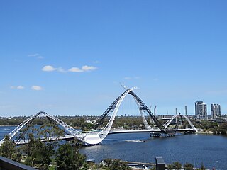
Matagarup Bridge is a suspension pedestrian bridge crossing over the Swan River in Perth, Western Australia. Situated approximately half-way between Heirisson Island and the Goongoongup Bridge, it provides pedestrian access between Burswood and East Perth. The bridge connects visitors to the Burswood Peninsula, including the Perth Stadium, with public transport and car parks in East Perth and the Perth central business district.
Aberdeen Street is a street in the Perth suburbs of Perth and Northbridge that runs from a cul-de-sac west of Lord Street in the east to a cul-de-sac between Fitzgerald Street and the Mitchell Freeway in the west. The street has 42 locally listed places of significance, 18 of which are also listed on the State Register of Heritage Places.

