Transport in Perth, Western Australia

Last updated

Transport in Perth, Western Australia, is served by various means, among them an extensive highway/freeway network and a substantial system of commuter rail lines and bus routes. Public transport is managed by the Transperth agency.

Contents

History

Following the settlement of the Swan River Colony in 1829, the Swan River was the main transportation link between Perth and the port of Fremantle. [1] Land transportation was difficult as the only river crossing near Perth, a ford at the eastern end of the town, was often impassable for wagons and carts. The next crossing point was 32 kilometres (20 mi) upstream at Guildford, a major detour. [1] The only alternative to these river crossings were ferries, which operated from North Fremantle, [2] Preston Point, [3] [4] and The Narrows. [1]

Road transport

Perth has an extensive road network centred around three freeways and nine metropolitan highways. It has no toll roads.

Great Eastern Highway Great Eastern Highway in Mundaring.jpg
Great Eastern Highway

Highways and Freeways

The Mitchell Freeway connects the city centre to Joondalup, in Perth's northern suburbs. The Kwinana Freeway runs through and beyond the city's southern suburbs towards Mandurah and Bunbury. The Graham Farmer Freeway, incorporating the Northbridge tunnel, was built in 2000, primarily to provide a road link between East Perth and West Perth and act as a city bypass. [5]

The port city of Fremantle, and adjacent suburbs, are linked to the city centre via Stirling Highway, which travels on the north side of the Swan River after crossing into North Fremantle on the Stirling Bridge. On the southern side of the river, Canning Highway, which later continues on as Great Eastern Highway, connects Fremantle to Midland, north-east of the city centre. Leach Highway is a parallel route that terminates at the edge of Perth Airport. Marmion Avenue is the northern continuation of West Coast Highway, which runs near the coastline, from Swanbourne to Trigg. [5]

The arterial routes out of the Perth Metropolitan Region radiate out as a series of spokes. Stock Road, Rockingham Road, Patterson Road, Ennis Avenue, and Mandurah Road are part of Highway 1, and a coastal route to the areas south of Perth. Kwinana Freeway, and its continuation as Forrest Highway, provide a controlled access alternative (State Route 2) further inland, which meets up with Highway 1 (as Old Coast Road) at Lake Clifton, south of Mandurah. Albany Highway (State Route 30) travels in a south-easterly direction to Albany, Western Australia. At Armadale, in Perth's south-eastern suburbs, South Western Highway (State Route 20) branches off Albany Highway, heading south towards Walpole on Western Australia's southern coast. Brookton Highway (State Route 40) leads from Albany Highway in Kelmscott (just north of Armadale) south-east towards Brookton. [5]

From the Midland area, Great Eastern Highway connects to Kalgoorlie, and is part of National Highway 94, which leads to Adelaide, South Australia. Great Northern Highway links Perth to Wyndham in the state's north, and is the majority of National Highway 95 to Darwin, Northern Territory. It also carries Highway 1 northwards out of Perth. Toodyay Road (State Route 50) is a third route out of Midland, heading north-east to Toodyay. Wanneroo Road (State Route 60) is a north-western route from Perth towards Yanchep and beyond, and Marmion Avenue provides a parallel route to Yanchep. [5]

Ring Road

Roe Highway offers a controlled access route between the Kwinana Freeway, east of Jandakot, east of Fremantle, and Midland. There is a plan to extend Roe Highway, Perth's southern half of its ring road, towards Fremantle via overpasses and a tunnel. If the extension is approved, it will become Perth's only toll road. In Middle Swan, one suburb north of Midland, Reid Highway is the continuation of Roe Highway, travelling west to North Beach, where it meets Marmion Avenue.

Traffic congestion

Weekday traffic congestion is worst during the morning peak hour, when traffic regularly slows to almost half the speed limit, and sometimes to a standstill. Depending on the road, the weekday peak hour is usually about 7am to 8am, or 8am to 9am. [6] On weekends, congestion is worst later in the morning and harder to predict. Rather than being on roads into the central business district, it centres on beaches, shopping centres, white goods and other big-box stores, and children's sporting grounds, such as netball courts. [7]

Public transport

A Transperth commuter train Transperth Sets.JPG
A Transperth commuter train

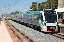
Perth metropolitan public transport, including trains, buses and ferries, are provided by Transperth, with links to rural areas provided by Transwa. Perth provides zero-fare train trips for SmartRider (travel fare card) holders around the city centre (the "Free Transit Zone"), as well as five high-frequency (every 8–15 minutes) Central Area Transit (CAT) bus routes (Red, Blue, Yellow, Green, Purple), which, alongside trips on regular Transperth buses in the city centre, are free to all users.

Suburban rail

There are five main rail lines, 76 stations and 15 bus stations in the metropolitan area.

Bus

Transperth bus Transperth Volgren bodied Volvo B8RLEA - Fremantle Train Station.jpg
Transperth bus

An extensive bus network services the greater Perth metro area. Many bus routes act as feeder routes to the main rail lines.

Regional and interstate rail

The Indian Pacific passenger rail service connects Perth with Adelaide and Sydney. The Prospector passenger rail service connects Perth with Kalgoorlie via several Wheatbelt towns, while the Australind connects to Bunbury, and the AvonLink connects to Northam.

Trams

Perth's first trams operated for a short period at the end of the nineteenth century, on an unsuccessful horse-car tramway between the GPO and East Perth. [8]

The city's first electric trams began operating in 1899 between East Perth and West Perth, along Hay Street in central Perth. The electric tram network was ultimately expanded west as far as Claremont, north as far as Osborne Park, and south across the Swan River causeway to Victoria Park, Como and Welshpool. [9]

The initial electric tram infrastructure in Perth was privately funded. The government took over the running of trams in 1914, with the aim of better co-ordinating the network. Trams were an integral part of the public transport system in the early 20th century until the advent of the private automobile. However, long term lack of government investment led to the network being phased out by July 1958. A number of Perth's historical trams are maintained at Whiteman Park.

Between 1905 and 1952, Fremantle had a small but comprehensive tramway network of its own. The Fremantle network was owned and operated by a consortium of local municipalities, and was never linked into the Perth network. Throughout its existence, the Fremantle network covered both the Fremantle municipality and the adjacent municipality of East Fremantle. Its tram lines also extended for part of that period into North Fremantle and Melville. [10]

There are now various tourist buses decorated as "trams", but running on rubber tyred wheels independently of rails, in both Perth and Fremantle. They operate services such as the Kings Park tram tour and others.

In 2012 a light rail network, to be known as the Metro Area Express was announced. After being pushed back, it was shelved in 2016. [11]

Cycling

Many of Perth's cycling routes run along other transport routes, such as rail lines and freeways. This makes them popular for commuters. Other routes in parks and along coastlines serve more recreational users. Principal Shared Path Along Perth Motorway II.jpg
Many of Perth's cycling routes run along other transport routes, such as rail lines and freeways. This makes them popular for commuters. Other routes in parks and along coastlines serve more recreational users.

Cycling in Perth is common on the roads and paths for recreation, commuting and sport. Between 1998 and 2009 the number of cyclists in Perth increased 450%. [12]

Airports

Perth is served by Perth Airport in the city's east for regional, domestic and international flights and Jandakot Airport in the city's southern suburbs for general aviation and charter flights.

Related Research Articles

The Kwinana Freeway is a 72-kilometre (45 mi) freeway in and beyond the southern suburbs of Perth, Western Australia, linking central Perth with Mandurah to the south. It is the central section of State Route 2, which continues north as Mitchell Freeway to Clarkson, and south as Forrest Highway towards Bunbury. A 4-kilometre (2.5 mi) section between Canning and Leach highways is also part of National Route 1. Along its route are interchanges with several major roads, including Roe Highway and Mandjoogoordap Drive. The northern terminus of the Kwinana Freeway is at the Narrows Bridge, which crosses the Swan River, and the southern terminus is at Pinjarra Road, east of Mandurah.

The Fremantle line is a suburban railway and service in Western Australia that connects the central business district (CBD) of Perth with Fremantle.

<span class="mw-page-title-main">Thornlie railway station</span> Railway station in Perth, Western Australia

Thornlie railway station is a temporarily closed railway station on the Transperth network. It was the terminus of the Thornlie line, a spur of the Armadale Line, seventeen kilometres (11 mi) from Perth Station serving the suburb of Thornlie, Western Australia. Under construction is the Thornlie-Cockburn Link which will link to Cockburn Central railway station along the Mandurah line via two new stations, Nicholson Road railway station and Ranford Road railway station.

<span class="mw-page-title-main">Mandurah line</span> Commuter rail line in Perth, Western Australia

The Mandurah line is a commuter railway and service on the Transperth network in Western Australia that runs from Perth south to the state's second largest city Mandurah. The service is operated by Transperth Train Operations, a division of the Public Transport Authority. The line is 70.1 kilometres (43.6 mi) long and has 12 stations. At its northern end, the line begins as a continuation of the Joondalup line at Perth Underground, and ends as a continuation of the Joondalup line at Elizabeth Quay. The first 1.3 kilometres (0.81 mi) of the line is underground, passing under the Perth central business district. The line surfaces and enters the median of the Kwinana Freeway just north of the Swan River. It continues south down the freeway's median for 30 kilometres (19 mi), before veering south-west towards Rockingham. The final stretch of the line goes south from Rockingham to Mandurah.

<span class="mw-page-title-main">Roe Highway</span> Highway in Perth, Western Australia

Roe Highway is a 35-kilometre-long (22 mi) limited-access highway and partial freeway in Perth, Western Australia, linking Kewdale with the city's north-eastern and south-western suburbs. The northern terminus is at Reid Highway and Great Northern Highway in Middle Swan, and the southern terminus is with Murdoch Drive at the Kwinana Freeway interchange in Bibra Lake. Roe Highway, in addition to Reid Highway, form State Route 3, a partial ring road around the outer suburbs of the Perth metropolitan area. Roe Highway also forms part of National Highway 94 from Great Eastern Highway Bypass to Great Eastern Highway, and National Highway 95 from Great Eastern Highway to Great Northern Highway.

<span class="mw-page-title-main">Safety Bay, Western Australia</span> Suburb of Perth, Western Australia

Safety Bay is an outer southern suburb of Perth, the capital city of Western Australia, located on the coast within the City of Rockingham.

<span class="mw-page-title-main">Canning Bridge railway station</span> Railway station in Perth, Western Australia

Canning Bridge railway station is a railway station on the Transperth network. It is located on the Mandurah line, four kilometres from Perth station inside the median strip of the Kwinana Freeway located adjacent to the suburb of Como.

<span class="mw-page-title-main">Bull Creek railway station</span> Railway station in Perth, Western Australia

Bull Creek railway station is a railway station on the Transperth network. It is located on the Mandurah line, 11.7 kilometres from Perth station inside the median strip of the Kwinana Freeway serving the suburb of Bull Creek.

<span class="mw-page-title-main">Canning Highway</span> Highway in Perth, Western Australia

Canning Highway is an arterial road in Perth, Western Australia, linking the inner Perth suburb of Victoria Park in the north-east, to the port city of Fremantle in the south-west.

<span class="mw-page-title-main">Leach Highway</span> Highway in Perth, Western Australia

Leach Highway is a 23-kilometre (14 mi) east-west arterial highway in the southern suburbs of Perth, Western Australia, primarily linking Kewdale and Perth Airport with the city of Fremantle.

<span class="mw-page-title-main">Kwinana railway station</span> Railway station in Perth, Western Australia

Kwinana railway station is a railway station in Bertram and Parmelia, suburbs of Perth, Western Australia. It is on the Mandurah railway line, which is part of the Transperth commuter rail network, and it serves the City of Kwinana. It has two side platforms located in a cutting, accessed by a ground-level station concourse. Services run every 10 minutes during peak, and every 15 minutes between peak. The journey to Perth railway station is 32.9 kilometres (20.4 mi), and takes 26 minutes. The station has a bus interchange with five bus stands, and five regular bus routes.

<span class="mw-page-title-main">Rockingham railway station, Perth</span> Railway station in Perth, Western Australia

Rockingham railway station is a railway station in Rockingham, a suburb of Perth, Western Australia. It is on the Mandurah railway line, which is part of the Transperth commuter rail network. It has two side platforms, linked by a pedestrian overpass accessed by stairs, a lift, and escalators. Services run every 10 minutes during peak, and every 15 minutes between peak. The journey to Perth railway station is 43.2 kilometres (26.8 mi), and takes 34 minutes. The journey to Mandurah railway station is 27.6 kilometres (17.1 mi), and takes 17 minutes. The station has a bus interchange with twelve bus stands, and 14 regular bus routes.

<span class="mw-page-title-main">Rail transport in Western Australia</span> Western Australia

Railways in Western Australia were developed in the 19th century both by the Government of Western Australia and a number of private companies. Today passenger rail services are controlled by the Public Transport Authority through Transperth, which operates public transport in Perth, and Transwa, which operates country passenger services. Journey Beyond operates the Indian Pacific.

<span class="mw-page-title-main">Railways in Perth</span> Public transport system serving Perth, Western Australia

Railways in Perth, the capital city of Western Australia, have existed since 1881, when the Eastern Railway was opened between Fremantle and Guildford. Today, Perth has seven Transperth commuter rail lines and 75 stations.

<span class="mw-page-title-main">Transperth</span> Public transport system serving Perth, Western Australia

Transperth is the public transport system for Perth and surrounding areas in Western Australia. It is managed by the Public Transport Authority (PTA), a state government organisation, and consists of train, bus and ferry services. Bus operations are contracted out to Swan Transit, Path Transit and Transdev. Ferry operations are contracted out to Captain Cook Cruises. Train operations are done by the PTA through their Transperth Train Operations division.

<span class="mw-page-title-main">Cycling in Perth</span>

Cycling in Perth, Western Australia is common on the roads and paths for recreation, commuting and sport. Between 1998 and 2009 the number of cyclists in Perth increased 450%.

<span class="mw-page-title-main">Trams in Fremantle</span> Tram network in Fremantle, Western Australia

The Fremantle tramway network linked the central business district of Fremantle, the port city for Perth, Western Australia, with nearby suburbs. Small but comprehensive, it operated between 1905 and 1952. It was not connected with the larger Perth tramway system.

<span class="mw-page-title-main">Rockingham, Western Australia</span> City in Western Australia

Rockingham is a suburb of Perth, Western Australia, located 47 km south-south-west of the city centre. It acts as the primary centre for the City of Rockingham. It has a beachside location at Mangles Bay, the southern extremity of Cockburn Sound. To its north stretches the maritime and resource-industry installations of Kwinana and Henderson. Offshore to the north-west is Australia's largest naval fleet and submarine base, Garden Island, connected to the mainland by an all-weather causeway. To the west and south lies the Shoalwater Islands Marine Park.

<span class="mw-page-title-main">Aubin Grove railway station</span> Railway station in Western Australia

Aubin Grove railway station is a commuter railway station serving Atwell, Aubin Grove, Hammond Park and Success, which are suburbs of Perth, Western Australia. It is on the Mandurah line, which is part of the Transperth network, and is located immediately north of Russell Road in the median of the Kwinana Freeway. It has two platform faces on a singular island platform, which is linked to either side of the freeway by a pedestrian overpass. Services run every 10 minutes during peak and every 15 minutes between peak. The journey to Perth railway station is 23.8 kilometres (14.8 mi) and takes 21 minutes. The station has a bus interchange with four bus stands and seven regular bus routes.

<span class="mw-page-title-main">Treeby, Western Australia</span> Suburb of Perth, Western Australia

Treeby is a southern suburb of Perth, Western Australia, located within the City of Cockburn. It is located on the east side of the Kwinana Freeway, close to Cockburn Central.

References

  1. 1 2 3 Edmonds, Leigh (1997). The Vital Link: A History of Main Roads Western Australia 1926-1996. Nedlands, Western Australia: University of Western Australia Press. pp. 12–14. ISBN   1-876268-06-9.
  2. "Proclamation". The Perth Gazette and Western Australian Journal . WA: National Library of Australia. 27 June 1835. p. 517. Retrieved 8 November 2012.
  3. "Ferry Charges". The Perth Gazette and Western Australian Journal . WA: National Library of Australia. 3 August 1833. p. 121. Retrieved 8 November 2012.
  4. "Fremantle Railway Bridge to Point Walter Reserve and Childley Point" (PDF). Swan River Trust. p. 6. Archived from the original (PDF) on 12 May 2013. Retrieved 8 November 2012.
  5. 1 2 3 4 "Metropolitan Arterial Roads, Perth, Western Australia (Map)" (PDF). Western Australian Land Information Authority. 2011. Retrieved 27 May 2012.
  6. Young, Emma (24 June 2018). "Perth peak hour hack: When you need to leave home to cut travel time". WA Today. Fairfax Media/Nine Entertainment Co. Retrieved 21 September 2019.
  7. Gubana, Benjamin (21 September 2019). "Perth's weekend traffic hotspots, where delays on the road rival the weekday peak hour". ABC News. Australian Broadcasting Corporation. Retrieved 21 September 2019.
  8. Brimson, Samuel (1983). The tramways of Australia. Dreamweaver Books. p. 159. ISBN   0-949825-01-8.
  9. Campbell, Bob (1999). Getting there by Tram in Western Australia. Perth, WA: Perth Electric Tramway Society Inc. ISBN   0646-38447-3.
  10. Chalmers, John (2001). David Hutchison (ed.). A ticket to ride : a history of the Fremantle Municipal tramways. Mt Lawley, WA: Perth Electric Tramway Society Inc. ISBN   978-0-9578257-0-3.
  11. "Fast facts". pta.wa.gov.au/. Western Australia Public Transport Authority. 18 December 2013. Retrieved 15 May 2015.
  12. Perth Bicycle Network Monitoring Archived 2009-09-18 at the Wayback Machine