Trigg, Western Australia

Last updated

Trigg
Perth,  Western Australia
Mettams new year sunset.jpg
Sunset over Mettam's Pool, 2006
Trigg, Western Australia
Coordinates 31°52′19″S115°45′32″E / 31.8719°S 115.759°E / -31.8719; 115.759
Population2,855 (SAL 2021) [1]
Established1940s
Postcode(s) 6029
Area2.4 km2 (0.9 sq mi)
Location14 km (9 mi) from Perth
LGA(s) City of Stirling
State electorate(s) Carine, Scarborough
Federal division(s)
Suburbs around Trigg:
North Beach Carine
Indian Ocean Trigg Karrinyup
Scarborough Doubleview

Trigg is a suburb of Perth, Western Australia. Its local government area is the City of Stirling. Trigg Island is a small island off the coast of the suburb of Trigg.

Contents

Overview

Trigg Beach is one of Perth's most popular beaches for board riding, catering mainly to surfers and body boarders alike, with a small majority of swimmers. In summer, shifting sand fills the channel between the blue hole and Trigg Point take off point for a long continuous wave ride to Trigg Beach.

Trigg also has a snorkelling beach, Mettam's Pool, which is to the north of the main surf/swim area.

Trigg nature reserve is situated opposite Trigg Beach. It is also known to be a common meeting point and lookout for the local surfing community.[ citation needed ]

With playground protection from the sun and sea breeze, Clarko beach side reserve near Trigg Island is one of the most popular parks in the City of Stirling. Clarko Reserve was created when beach shacks were demolished and shack owners were compensated with sub-divided blocks of residential land further east in the new Trigg suburb.

History

The suburb and island was named after "Henry Trigg", Superintendent of Public Works for the Swan River Colony in 1842. [2] [3] First time when land at Trigg was taken up, reaches back to 1877. Not until the late 1940s, Trigg has started to develop, whereby many of the streets reaching through it were named after former residents, pioneers and local personalities. [4]

Transport

Bus

Related Research Articles

<span class="mw-page-title-main">Balcatta, Western Australia</span> Suburb of Perth, Western Australia

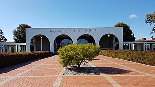
Balcatta is a suburb of Perth, Western Australia. Its local government area is the City of Stirling. It is a primarily middle-class suburb made up of mainly Italian, Greek and Macedonian families, as well as many families from other European countries. It is also one of the largest suburbs in the northern part of the Perth metropolitan area. Much of Balcatta is a commercial and industrial area.

<span class="mw-page-title-main">Carine, Western Australia</span> Suburb of Perth, Western Australia

Carine is a suburb of Perth, the capital city of Western Australia, and is located 14 kilometres (9 mi) north of Perth's central business district (CBD) between Marmion Avenue and Mitchell Freeway. Its local government area is the City of Stirling.

<span class="mw-page-title-main">Gwelup, Western Australia</span> Suburb of Perth, Western Australia

Gwelup is a suburb of Perth, the capital city of Western Australia 12 km north of Perth's central business district (CBD) along the Mitchell Freeway. Its local government area is the City of Stirling.

<span class="mw-page-title-main">Innaloo, Western Australia</span> Suburb of Perth, Western Australia

Innaloo is a suburb of Perth, the capital city of Western Australia, 9 km (5.6 mi) from Perth's central business district in the local government area of the City of Stirling.

<span class="mw-page-title-main">Karrinyup, Western Australia</span> Suburb of Perth, Western Australia

Karrinyup is a suburb of Perth, the capital city of Western Australia, and is located 12 km north of Perth's central business district. Its local government area is the City of Stirling.

<span class="mw-page-title-main">North Beach, Western Australia</span> Suburb of Perth, Western Australia

North Beach is a northern coastal suburb of Perth, the capital city of Western Australia 16 kilometres (10 mi) from Perth's central business district via Mitchell Freeway and Reid Highway. Its local government area is the City of Stirling.

<span class="mw-page-title-main">Tuart Hill, Western Australia</span> Suburb of Perth, Western Australia

Tuart Hill is a suburb of Perth, Western Australia.

<span class="mw-page-title-main">Cottesloe, Western Australia</span> Suburb of Perth, Western Australia

Cottesloe is a western suburb of Perth, Western Australia, within the Town of Cottesloe. Cottesloe was named for Thomas Fremantle, 1st Baron Cottesloe, a prominent Tory politician and the brother of Admiral Sir Charles Fremantle for whom the city of Fremantle was named. The nearby suburb of Swanbourne was named for the Fremantle family seat, Swanbourne House, in Swanbourne, Buckinghamshire.

<span class="mw-page-title-main">Peppermint Grove, Western Australia</span> Suburb of Perth, Western Australia

Peppermint Grove is an affluent western suburb of Perth, Western Australia on the north bank of the Swan River at Freshwater Bay. Its local government area, the smallest in the country, is the Shire of Peppermint Grove. The suburb was named after its trademark Swan River peppermint trees lining many streets. The suburb has long been associated with Western Australia's wealthiest and oldest families. Their prosperity is reflected in the many historical houses in the area, such as The Cliffe and the Federation Queen Anne style St Just. Colin Barnett, a former Premier of Western Australia, dubbed the suburb "Monaco of WA" due to its small size and concentration of wealth. It is also known as millionaire’s row and had the highest income of any suburb in Australia in 2022.

<span class="mw-page-title-main">Stirling railway station, Perth</span> Railway station in Perth, Western Australia

Stirling railway station is a railway station on the Transperth network. It is located on the Joondalup line, nine kilometres from Perth station serving the suburb of Stirling.

<span class="mw-page-title-main">Sorrento, Western Australia</span> Suburb of Perth, Western Australia

Sorrento is a northern coastal suburb of Perth, the capital city of Western Australia in the local government area of the City of Joondalup. At its northwestern corner is the Hillarys Boat Harbour, built in the late 1980s.

<span class="mw-page-title-main">Karrinyup bus station</span> Bus station in Karrinyup, Western Australia

Karrinyup bus station is a Transperth bus station located next to Karrinyup Shopping Centre in Karrinyup, approximately 10 kilometres north of Perth, Western Australia. It has four stands and is served by five Transperth routes operated by Swan Transit.

<span class="mw-page-title-main">Watermans Bay, Western Australia</span> Suburb of Perth, Western Australia

Watermans Bay is a northern coastal suburb of Perth, the capital city of Western Australia. Its local government area is the City of Stirling.

<span class="mw-page-title-main">Duncraig, Western Australia</span> Suburb of Perth, Western Australia

Duncraig is a northern suburb of Perth, the capital city of Western Australia, and is located 16 kilometres (10 mi) north of Perth's central business district (CBD) between Marmion Avenue and Mitchell Freeway. Its local government area is the City of Joondalup.

<span class="mw-page-title-main">North Perth, Western Australia</span> Suburb of Perth, Western Australia

North Perth is a suburb of Perth, Western Australia, located within the City of Vincent.

Hillarys is a northern coastal suburb of Perth, the capital city of Western Australia, in the local government area of the City of Joondalup. It is part of the Whitfords precinct, and is located 21 km north-northwest of Perth's central business district via Mitchell Freeway and Hepburn Avenue.

<span class="mw-page-title-main">Marmion, Western Australia</span> Suburb of Perth, Western Australia

Marmion is a northern coastal suburb of Perth, the capital city of Western Australia. Its local government area is the City of Joondalup.

<span class="mw-page-title-main">Stirling, Western Australia</span> Suburb of Perth, Western Australia

Stirling is a suburb of Perth, the capital city of Western Australia, about 10 km north of Perth's central business district (CBD) along the Mitchell Freeway. Its local government area is the City of Stirling, whose council offices and administration centre are located in the southwest of the mostly residential suburb.

<span class="mw-page-title-main">Nedlands, Western Australia</span> Suburb of Perth, Western Australia

Nedlands is a western suburb of Perth, the capital city of Western Australia. It is a part of the local government areas of the City of Nedlands and the City of Perth. It is about 7 kilometres (4 mi) from the Perth CBD via either Thomas Street or Mounts Bay Road.

<span class="mw-page-title-main">West Coast Drive</span> Road in Perth, Western Australia

West Coast Drive is a scenic north-south route along the Indian Ocean in the northern suburbs of Perth, Western Australia.

References

  1. Australian Bureau of Statistics (28 June 2022). "Trigg (suburb and locality)". Australian Census 2021 QuickStats. Retrieved 28 June 2022.  OOjs UI icon edit-ltr-progressive.svg
  2. "Life on Perth - Trigg Beach". 2004. Retrieved 4 September 2009.
  3. "About the City - Suburbs - Trigg". City of Stirling. Archived from the original on 5 September 2013. Retrieved 2 April 2013.
  4. "City of Stirling - Trigg".
  5. "Route 423". Bus Timetable 62 (PDF). Transperth. 11 January 2024 [effective from 28 January 2024].
  6. "Route 424". Bus Timetable 61 (PDF). Transperth. 25 October 2023 [effective from 17 December 2023].