
Hamersley is a residential suburb 14 kilometres north-northwest of the central business district of Perth, the capital of Western Australia, and six kilometres (4 mi) from the Indian Ocean. The suburb adjoins two major arterial roads—Mitchell Freeway to the west and Reid Highway to the south—and is within the City of Stirling local government area. It was built during the late 1960s and 1970s as part of the Government of Western Australia's response to rapidly increasing land prices across the metropolitan area.

The City of Nedlands is a local government area in the inner western suburbs of the Western Australian capital city of Perth, about 7 kilometres (4 mi) west of Perth's central business district. The city is situated within the western suburbs of the metropolitan area—known colloquially as the “golden triangle” for the concentration of wealth and high housing values.

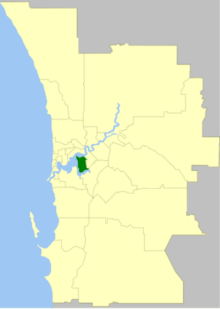
The Town of Cambridge is a local government area in the inner western suburbs of the Western Australian capital city of Perth, about 5 kilometres (3 mi) west of Perth's central business district and extending to the Indian Ocean at City Beach. The Town covers an area of 22.0 square kilometres (8.5 sq mi) and had a population of almost 29,000 as of the 2021 Census. It was originally part of the City of Perth before the restructuring by the Western Australian State Government in 1994.

The City of Canning is a local government area in the southeastern suburbs of the Western Australian capital city of Perth, about 10 kilometres (6 mi) southeast of Perth's central business district. The City covers an area of 64.8 square kilometres (25.0 sq mi) and had a population of approximately 90,000 as at the 2016 Census.
The City of South Perth is a local government area in the inner southern suburbs of the Western Australian capital city of Perth about 4 kilometres (2.5 mi) south of Perth's central business district. The City covers an area of 19.9 square kilometres (7.7 sq mi), maintains 203 kilometres (126 mi) of roads and a little over 4.3 km2 of parks and gardens, and had a population of about 42,000 at the 2016 Census. The City is the entirety of the state electoral district of South Perth. An area of Kensington joined into South Perth after the 2013 redistribution, although dwindling population growth in Victoria Park may mean that part of the City will move back.

The Town of Victoria Park is a local government area of Western Australia. It covers an area of 17.62 km² in metropolitan Perth, the capital of Western Australia. It had a population of approximately 35,000 as at the 2016 census.

The City of Vincent is a local government area of Western Australia. It covers an area of approximately 10.4 square kilometres (4.0 sq mi) in metropolitan Perth, the capital of Western Australia, and lies about 3 km from the Perth CBD. The City of Vincent maintains 139 km of roads and 104 ha of parks and gardens. It had a population of over 33,000 at the 2016 Census.

The City of Wanneroo is a local government area with city status in the northern suburbs of Perth, Western Australia. It is centred approximately 25 kilometres (15.5 mi) north of Perth's central business district and forms part of the northern boundary of the Perth metropolitan area. Wanneroo encompasses the federal divisions of Cowan, Moore and Pearce.

Joondalup is a suburb of Perth, Western Australia, approximately 26 kilometres (16 mi) north of Perth's central business district. It contains the central business district of the regional City of Joondalup and acts as the primary urban centre of Perth's outer northern suburbs.

Alkimos is a coastal suburb of Perth, Western Australia, located 42 kilometres (26 mi) north-northwest of Perth's central business district. It is part of the City of Wanneroo local government area.

Beeliar is a suburb of Perth, Western Australia, located within the City of Cockburn. The name refers to the Beeliar people, a group of Aboriginal Australians who had land rights over the southern half of Perth's metropolitan area. The suburb contains the Thomsons Lake Nature Reserve.

Woodbridge is a suburb of Perth, Western Australia, located within the City of Swan local government area. Formerly part of Midland and previously informally named West Midland, its name, which was officially gazetted on 1 March 2001, is from Governor James Stirling's original 1829 land grant which he named after his wife's family property near Guildford in England.
The City of Joondalup is a local government area in Perth, Western Australia. Its central business district is located in the suburb Joondalup, and it includes the town centres of Hillarys and Warwick.

Cooloongup is an outer southern suburb of Perth, Western Australia, the capital city of Western Australia, located within the City of Rockingham. It consists mainly of residential dwellings.

Ellenbrook is an outer suburb and planned community in Perth, Western Australia, within the City of Swan local government area. It is 28 km (17 mi) north-east of Perth's central business district and 18 km (11 mi) north of the regional metropolitan centre of Midland. It was first developed in the 1990s as a joint venture between the Government of Western Australia and private landowners in the area.

The City of Perth is a local government area and body, within the Perth metropolitan area, which is the capital of Western Australia. The local government is commonly known as Perth City Council. The City covers the Perth city centre and surrounding suburbs. The City covers an area of 20.01 square kilometres (8 sq mi) and had an estimated population of 21,092 as at 30 June 2015. On 1 July 2016 the City expanded, absorbing 1,247 residents from the City of Subiaco.

The City of Mandurah is a local government area of Western Australia, covering both Mandurah proper and an additional area reaching down as far south as Lake Clifton. The city has a total area of approximately 174 square kilometres (67 sq mi).

The City of Kalamunda is a local government area in the eastern metropolitan region of the Western Australian capital city of Perth about 25 kilometres (16 mi) east of Perth's central business district. The area covers 324 square kilometres (125 sq mi), much of which is state forest rising into the Darling Scarp to the east. As of 2021, the city had a population of 58,762.

The Town of Bassendean is a local government area in the northeastern suburbs of the Western Australian capital city of Perth, 6 kilometres (4 mi) west of the industrial centre of Midland and about 12 kilometres (7 mi) northeast of Perth's central business district. The Town covers an area of 10.4 square kilometres (4.0 sq mi), maintains 97 km of roads and had a population of approximately 15,000 as at the 2016 Census. The Town of Bassendean is a member of the Eastern Metropolitan Regional Council.
Ajana is a townsite within the Shire of Northampton in Western Australia. It is located at the junction of Ajana-Kalbarri Road and Ajana Back Road, 53 kilometres (33 mi) by road north of Northampton, 61 kilometres (38 mi) by road southwest of Kalbarri, and 531 kilometres (330 mi) west-northwest of Perth in the Mid West region.