
The Murrumbidgee River is a major tributary of the Murray River within the Murray–Darling basin and the second longest river in Australia. It flows through the Australian state of New South Wales and the Australian Capital Territory, descending 1,500 metres (4,900 ft) over 1,485 kilometres (923 mi), generally in a west-northwesterly direction from the foot of Peppercorn Hill in the Fiery Range of the Snowy Mountains towards its confluence with the Murray River near Boundary Bend.

Wagga Wagga is a major regional city in the Riverina region of New South Wales, Australia. Straddling the Murrumbidgee River, with an urban population of more than 57,003 as of 2021, it is an important agricultural, military, and transport hub of Australia. The ninth largest inland city in Australia, Wagga Wagga is located midway between the two largest cities in Australia—Sydney and Melbourne—and is the major regional centre for the Riverina and South West Slopes regions.

The Macquarie River or Wambuul is part of the Macquarie–Barwon catchment within the Murray–Darling basin, is one of the main inland rivers in New South Wales, Australia.

Sturt Highway is an Australian national highway in New South Wales, Victoria, and South Australia. It is an important road link for the transport of passengers and freight between Sydney and Adelaide and the regions along the route.

The Riverina is an agricultural region of southwestern New South Wales, Australia. The Riverina is distinguished from other Australian regions by the combination of flat plains, warm to hot climate and an ample supply of water for irrigation. This combination has allowed the Riverina to develop into one of the most productive and agriculturally diverse areas of Australia. Bordered on the south by the state of Victoria and on the east by the Great Dividing Range, the Riverina covers those areas of New South Wales in the Murray and Murrumbidgee drainage zones to their confluence in the west.

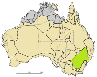
The Division of Riverina is an Australian electoral division in the state of New South Wales.

Lavington is the largest suburb of the city of Albury, New South Wales, Australia. At the 2021 census, Lavington had a population of 13,073. Lavington is a mostly flat area near Nail Can Hill to the west, and is bordered by Thurgoona to the east, Hamilton Valley to the west, Springdale Heights to the north, and North Albury to the south. Lavington is mostly residential, but has significant rural areas in the north-west and a commercial area. Features include Lavington Square Shopping Centre, Lavington Swim Centre, Jelbart Park and 5 schools . Lavington is the second major centre of the City of Albury, with its own commercial CBD.
Wiradjuri is a Pama–Nyungan language of the Wiradhuric subgroup. It is the traditional language of the Wiradjuri people, an Aboriginal Australian people of New South Wales, Australia. Wiraiari and Jeithi may have been dialects.

Bourkelands is a rapidly developing southern suburb of Wagga Wagga in southern New South Wales, Australia which is named after a property which was located within the suburb. The suburb consists predominantly of real estate display homes and housing for military staff at the nearby RAAF Base Wagga and Army Recruit Training Centre. The suburb borders Red Hill Road and is within walking distance of the Tolland shopping centre and Jubilee Park/Oval and contains two play parks. The suburb also contains the area which is commonly marketed by real estate agents and developers as Hilltop, as the name Hilltop is not registered locality.

Bomen is a northern suburb of Wagga Wagga in southern New South Wales, Australia. The suburb is dominated by industrial enterprises including Cargill Beef, Watties, the Wagga Wagga Livestock Marketing Centre (saleyards). The suburb is also home to Wagga Wagga's secondary railway station on the Main Southern line, when the line waited for the construction of a bridge over the Murrumbidgee River. New streets in Bomen are to be named after sheep and cattle breeds.
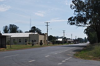
Ladysmith is a village approximately 19 km east of Wagga Wagga in the Riverina region of New South Wales, Australia. At the 2021 census, Ladysmith had a population of 215 people.

The South Western Slopes, also known as the South West Slopes, is a region predominantly in New South Wales, Australia. It covers the lower inland slopes of the Great Dividing Range, extending from north of Dunedoo through central NSW and into north-east Victoria, meeting its south-western end around Beechworth. More than 90% of the region is in the state of New South Wales and it occupies about 10% of that state – more than 80,000 km2.

City of Wagga Wagga is a local government area in the Riverina region of southern New South Wales, Australia.

Gumly Gumly is a suburb of the city of Wagga Wagga, New South Wales, Australia and is located approximately 8 km east of the CBD on the Sturt Highway.

The Murrumbidgee Valley National Park is a protected national park that is located in the Riverina region of New South Wales, in eastern Australia. The 47,703-hectare (117,880-acre) national park is located approximately 6 kilometres (3.7 mi) east of Hay, and approximately 15 kilometres (9.3 mi) west of Narrandera. The park protects part of what is now the largest continuous tract of river red gum forest in the world.
Bullock Hill Conservation Park is a protected area located in the Australian state of South Australia in the locality of Ashbourne about 45 kilometres (28 mi) south of the state capital of Adelaide and about 10 kilometres (6.2 mi) south-west of the town of Strathalbyn.
Kyeamba Shire was a local government area in the Riverina region of New South Wales, Australia.