External links
Lists of suburbs of Australian cities and metropolitan areas | |
|---|---|
| Capital cities | |
| NSW | |
| QLD | |
| TAS | |
| WA | |
| VIC | |
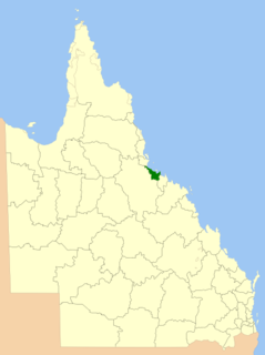
This article is a list of suburbs and settlements that make up the City of Townsville in Queensland, Australia. They are listed relative to their historical local government area from prior to 2008 when City of Townsville and City of Thuringowa were separate local government areas. For the main article/s, see Townsville, and City of Townsville.
1 - includes James Cook University
2 - includes Lavarack Barracks

Townsville is a city on the north-eastern coast of Queensland, Australia. With a population of 180,820 as of June 2018, it is the largest settlement in North Queensland and is unofficially considered its capital. Townsville hosts a significant number of governmental, community and major business administrative offices for the northern half of the state.

The City of Thuringowa was a city and local government area in North Queensland, Australia covering the northern and western parts of what is now Townsville. The suburb of Thuringowa Central is the main business centre in this area.

North Queensland or the Northern Region is the northern part of the Australian state of Queensland that lies just south of Far North Queensland. Queensland is a massive state, larger than many countries, and its tropical northern part has been historically remote and undeveloped, resulting in a distinctive regional character and identity.

The Ross River is a river located in northern Queensland, Australia. The 49-kilometre (30 mi) long river flows through the city of Townsville and empties into the Coral Sea. It is the major waterway flowing through Townsville and the city's main source of drinking water.

Townsville is an electoral district of the Legislative Assembly in the Australian state of Queensland. The seat is one of four within the Townsville urban area in North Queensland, and covers the Eastern and Northern suburbs of the City of Townsville as well as Magnetic Island and Palm Island.
This article is about Transport in Townsville, Queensland.

The Shire of Dalrymple was a local government area located in North Queensland, Australia, and surrounded but did not include the town of Charters Towers, at which its council and administrative centre was based. It covered an area of 68,324.5 square kilometres (26,380.2 sq mi), and existed as a local government entity from 1879 until 2008, when it amalgamated with the separate City of Charters Towers to form the Charters Towers Region.
Alice River is an outher suburb suburb in the City of Townsville, Queensland, Australia. In the 2016 census Alice River had a population of 2,425 people.

The City of Townsville is a local government area (LGA) located in North Queensland, Australia. It encompasses the city of Townsville, together with the surrounding rural areas, to the south are the communities of Alligator Creek, Woodstock and Reid River, and to the north are Northern Beaches and Paluma, and also included is Magnetic Island. In June 2018 the area had a population of 194,072, and is the 28th-largest LGA in Australia. Townsville is considered to be the unofficial capital of North Queensland.

The City of Charters Towers was a local government area in North Queensland, Australia, consisting of the centre and suburbs of the town of Charters Towers. Established in 1877, it was entirely surrounded by the Shire of Dalrymple, with which it amalgamated in 2008 to form the Charters Towers Region.

Rowes Bay is a suburb of Townsville in the City of Townsville, Queensland, Australia. In the 2016 census, Rowes Bay had a population of 573 people.

Mysterton is a suburb in the City of Townsville, Queensland, Australia. In the 2016 census Mysterton had a population of 809 people.

The Charters Towers Region is a local government area in North Queensland, Australia southwest of, and inland from the city of Townsville, based in Charters Towers. Established in 2008, it was preceded by two previous local government areas which dated back to the 1870s.
Suburbs and localities are the names of geographic subdivisions in Australia, used mainly for address purposes. The term locality is used in rural areas, while the term suburb is used in urban areas. Australian postcodes closely align with the boundaries of localities and suburbs.
Saunders Beach is a coastal town and suburb of Townsville in the City of Townsville, Queensland, Australia. In the 2016 census, the suburb of Saunders Beach had a population of 409 people.

The metropolis of Sydney in New South Wales, Australia, is informally subdivided into a number of geographic regions. These areas sometimes, but not always, roughly coincide with official boundaries of suburbs, local government authorities, or cadastral units, and some of the customary regions do not have well defined boundaries at all. Some commonly referred to regions overlap: for example, "Canterbury-Bankstown" is often referred to as a region, but it is also part of the "South Western Sydney" region. The regions themselves are not used as a formal jurisdiction, and generally do not have administrative or legislative bodies, although some regions are coterminous with a local government area, and in a number of regions that include multiple local government areas, Regional Organisations of Councils have been established that represent the councils in the region.
Toomulla is a coastal town and suburb in the City of Townsville, Queensland, Australia. In the 2016 census, Toomulla had a population of 183 people.
CityLibraries Townsville is a public library service serving the City of Townsville, Queensland, Australia. It has three permanent libraries, a mobile library service and a home service. It is operated by Townsville City Council. CityLibraries serves almost 200,000 residents of Townsville and surrounding areas. CityLibraries vision is "Connections for Life" and the mission is "Working with our community to connect people, information, learning and lifestyle".
Hervey Range is a rural locality split between the City of Townsville and the Charters Towers Region, Queensland, Australia. In the 2016 census Hervey Range had a population of 279 people.