Gulliver, Queensland

Last updated

Gulliver
Townsville,  Queensland
Gulliver Queensland.jpg
McDonald Street, Gulliver
Townsville locator map.svg
Red pog.svg
Gulliver
Coordinates 19°17′13″S146°46′30″E / 19.2869°S 146.7749°E / -19.2869; 146.7749 (Gulliver (centre of suburb))
Population2,825 (2016 census) [1]
 • Density1,570/km2 (4,060/sq mi)
Postcode(s) 4812
Area1.8 km2 (0.7 sq mi)
Time zone AEST (UTC+10:00)
LGA(s) City of Townsville
State electorate(s)
Federal division(s) Herbert
Suburbs around Gulliver:
Vincent Currajong Currajong
Vincent Gulliver Pimlico
Aitkenvale Aitkenvale Mundingburra

Gulliver is a suburb in the City of Townsville, Queensland, Australia. [2] In the 2016 census Gulliver had a population of 2,825 people. [1]

Contents

History

Gulliver is situated in the traditional Wulgurukaba Aboriginal country. [3]

The suburb is named after Thomas Allen Gulliver, the telegraph master of Townsville. [2]

It is unclear when the Holy Family Catholic Primary School opened in Gulliver, but it closed on 11 December 1987. It was then amalgamated with St John Fisher's Christian Brothers College (Currajong) and St Margaret Mary's Primary School (Hermit Park) to create The Marian School which opened on 21 January 1988 in Currajong. [4] [5] In 1995, St Mary's School (West End) was amalgamated into The Marian School. [4] [6]

Currajong State School opened on 28 June 1954. [7]

Pimlico State High School opened on 27 January 1959. [7]

In the 2016 census Gulliver had a population of 2,825 people. [1]

Education

Despite the name, Currajong State School is a government primary (Prep–6) school for boys and girls at 140 Palmerston Street in Gulliver, adjacent to Currajong's southern boundary ( 19°16′49″S146°46′27″E / 19.2802°S 146.7741°E / -19.2802; 146.7741 (Currajong State School) ). [8] [9] [10] In 2018, the school had an enrolment of 602 students with 46 teachers (42 full-time equivalent) and 26 non-teaching staff (19 full-time equivalent). [11] It includes a special education program. [8]

Despite the name, Pimlico State High School is a government secondary (7–12) school for boys and girls at Fulham Road in Gulliver, adjacent to Pimlico's western boundary ( 19°17′19″S146°46′57″E / 19.2887°S 146.7826°E / -19.2887; 146.7826 (Pimlico State High School) ). [8] [12] [10] In 2018, the school had an enrolment of 1658 students with 136 teachers (127 full-time equivalent) and 56 non-teaching staff (42 full-time equivalent). [11] It includes a special education program. [8]

Queensland Pathways State College is at Desailly Street ( 19°17′07″S146°46′50″E / 19.2852°S 146.7805°E / -19.2852; 146.7805 (Queensland Pathways State College) ) within the TAFE Queensland campus. It is the Townsville campus of the secondary (10–12) Queensland Pathways State College which has its headquarters at Coorparoo in Brisbane. The school specialises in students who have difficulties with mainstream education. [8] [13] [10]

Related Research Articles

<span class="mw-page-title-main">Annandale, Queensland</span> Suburb of Townsville, Queensland, Australia

Annandale is a suburb of Townsville in the City of Townsville, Queensland, Australia. In the 2016 census, Annandale had a population of 8,574 people.

<span class="mw-page-title-main">Garbutt, Queensland</span> Suburb of Townsville, Queensland, Australia

Garbutt is a suburb of Townsville in the City of Townsville, Queensland, Australia. It is home to the Townsville International Airport and RAAF Townsville.

<span class="mw-page-title-main">Aitkenvale, Queensland</span> Suburb of Townsville, Queensland, Australia

Aitkenvale is a suburb of Townsville in the City of Townsville, Queensland, Australia. In the 2016 census, Aitkenvale had a population of 4,790 people.

Hyde Park is a suburb in the City of Townsville, Queensland, Australia. In the 2016 census Hyde Park had a population of 1,387 people.

West End is an inner suburb of Townsville in the City of Townsville, Queensland, Australia. In the 2016 census, West End had a population of 4,064 people.

<span class="mw-page-title-main">Belgian Gardens, Queensland</span> Suburb of Townsville, Queensland, Australia

Belgian Gardens is an inner coastal suburb of Townsville in the City of Townsville, Queensland, Australia. In the 2016 census Belgian Gardens had a population of 2,069 people.

<span class="mw-page-title-main">South Townsville, Queensland</span> Suburb of Townsville, Queensland, Australia

South Townsville is a coastal suburb of Townsville in the City of Townsville, Queensland, Australia. In the 2016 census, South Townsville had a population of 2,353 people.

<span class="mw-page-title-main">Railway Estate, Queensland</span> Suburb of Townsville, Queensland, Australia

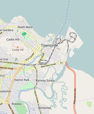
Railway Estate is a suburb of Townsville in the City of Townsville, Queensland, Australia. In the 2016 census Railway Estate had a population of 2,852 people.

<span class="mw-page-title-main">Deeragun, Queensland</span> Suburb of Townsville, Queensland, Australia

Deeragun is an outer western town and suburb of Townsville in the City of Townsville, Queensland, Australia. In the 2016 census, Deeragun had a population of 4,250 people.

<span class="mw-page-title-main">Hermit Park, Queensland</span> Suburb of Townsville, Queensland, Australia

Hermit Park is a suburb of Townsville in the City of Townsville, Queensland, Australia. In the 2016 census Hermit Park had a population of 3,414 people.

Mundingburra is a suburb of Townsville in the City of Townsville, Queensland, Australia. In the 2016 census, Mundingburra had a population of 3,620 people.

<span class="mw-page-title-main">Idalia, Queensland</span> Suburb of Townsville, Queensland, Australia

Idalia is a southern suburb in the City of Townsville, Queensland, Australia. In the 2016 census Idalia had a population of 4,438 people.

Condon is a suburb of Townsville in the City of Townsville, Queensland, Australia. In the 2016 census, Condon had a population of 5,779 people.

<span class="mw-page-title-main">North Ward, Queensland</span> Suburb of Townsville, Queensland, Australia

North Ward is a coastal suburb of Townsville in the City of Townsville, Queensland, Australia. In the 2016 census, North Ward had a population of 5,065 people.

<span class="mw-page-title-main">Pimlico, Queensland</span> Suburb of Townsville, Queensland, Australia

Pimlico is a suburb of Townsville in the City of Townsville, Queensland, Australia. In the 2016 census Pimlico had a population of 2,460 people.

Cranbrook is a suburb of Townsville in the City of Townsville, Queensland, Australia. In the 2016 census, Cranbrook had a population of 5,908 people.

<span class="mw-page-title-main">Currajong, Queensland</span> Suburb of Townsville, Queensland, Australia

Currajong is a suburb in the City of Townsville, Queensland, Australia. In the 2016 census, Currajong had a population of 2,548 people.

<span class="mw-page-title-main">Rosslea, Queensland</span> Suburb of Townsville, Queensland, Australia

Rosslea is a suburb of Townsville in the City of Townsville, Queensland, Australia. In the 2016 census Rosslea had a population of 1,732 people.

<span class="mw-page-title-main">Heatley, Queensland</span> Suburb of Townsville, Queensland, Australia

Heatley is a suburb in the City of Townsville, Queensland, Australia. In the 2016 census, Heatley had a population of 4,038 people.

<span class="mw-page-title-main">Burdell, Queensland</span> Suburb of Townsville, Queensland, Australia

Burdell is a suburb of Townsville in the City of Townsville, Queensland, Australia. In the 2021 census, Burdell had a population of 7,171 people.

References

  1. 1 2 3 Australian Bureau of Statistics (27 June 2017). "Gulliver (SSC)". 2016 Census QuickStats. Retrieved 20 October 2018. OOjs UI icon edit-ltr-progressive.svg
  2. 1 2 "Gulliver – suburb in City of Townsville (entry 44596)". Queensland Place Names. Queensland Government . Retrieved 29 December 2020.
  3. "Traditional Landowners - History and Heritage". Archived from the original on 27 March 2020. Retrieved 25 June 2020.
  4. 1 2 Queensland Family History Society (2010), Queensland schools past and present (Version 1.01 ed.), Queensland Family History Society, ISBN   978-1-921171-26-0
  5. "St. John Fishers, Currajong". www.ozatwar.com. Archived from the original on 1 July 2017. Retrieved 19 August 2021.
  6. "Overview | Marian Catholic School, Currajong". Overview | Marian Catholic School, Currajong. Archived from the original on 11 April 2021. Retrieved 19 August 2021.
  7. 1 2 Queensland Family History Society (2010), Queensland schools past and present (Version 1.01 ed.), Queensland Family History Society, ISBN   978-1-921171-26-0
  8. 1 2 3 4 5 "State and non-state school details". Queensland Government. 9 July 2018. Archived from the original on 21 November 2018. Retrieved 21 November 2018.
  9. "Currajong State School". Archived from the original on 24 February 2021. Retrieved 21 November 2018.
  10. 1 2 3 "Queensland Globe". State of Queensland . Retrieved 1 January 2021.
  11. 1 2 "ACARA School Profile 2018". Australian Curriculum, Assessment and Reporting Authority. Archived from the original on 27 August 2020. Retrieved 28 January 2020.
  12. "Pimlico State High School". Archived from the original on 19 August 2021. Retrieved 21 November 2018.
  13. "Queensland Pathways State College". Archived from the original on 19 March 2020. Retrieved 21 November 2018.