
Garbutt is a suburb of Townsville in the City of Townsville, Queensland, Australia. It is home to the Townsville International Airport and RAAF Townsville. In the 2021 census, Garbutt had a population of 2,309 people.

Aitkenvale is a suburb of Townsville in the City of Townsville, Queensland, Australia. In the 2021 census, Aitkenvale had a population of 4,797 people.

Mount Louisa is a residential suburb in the City of Townsville, Queensland, Australia. The suburb contains the mountain Mount Louisa. In the 2021 census, Mount Louisa had a population of 9,227 people.
Wulguru is an outer southern suburb of Townsville in the City of Townsville, Queensland, Australia. In the 2021 census, Wulguru had a population of 4,389 people.

Belgian Gardens is an inner coastal suburb of Townsville in the City of Townsville, Queensland, Australia. In the 2021 census, Belgian Gardens had a population of 2,073 people.

Oonoonba is a suburb of Townsville in the City of Townsville, Queensland, Australia. In the 2021 census, Oonoonba had a population of 2,050 people.

South Townsville is a coastal suburb of Townsville in the City of Townsville, Queensland, Australia. In the 2021 census, South Townsville had a population of 2,424 people.
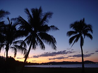
Rowes Bay is a suburb of Townsville in the City of Townsville, Queensland, Australia. In the 2021 census, Rowes Bay had a population of 541 people.
Mundingburra is a suburb of Townsville in the City of Townsville, Queensland, Australia. In the 2021 census, Mundingburra had a population of 3,594 people.

Thuringowa Central is a suburb of Townsville in the City of Townsville, Queensland, Australia. In the 2021 census, Thuringowa Central had a population of 1,953 people.

Rasmussen is a suburb of Townsville in the City of Townsville, Queensland, Australia. In the 2021 census, Rasmussen had a population of 4,669 people.

Pallarenda is a northern coastal suburb of Townsville in the City of Townsville, Queensland, Australia. In the 2021 census, Pallarenda had a population of 778 people.
Cranbrook is a suburb of Townsville in the City of Townsville, Queensland, Australia. In the 2021 census, Cranbrook had a population of 5,844 people.

Cape Cleveland is a rural locality in the City of Townsville, Queensland, Australia. In the 2021 census, Cape Cleveland had a population of 128 people.
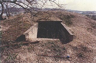
Mount St John Anti-Aircraft Battery is a heritage-listed fortification at 43 Toll Street, Mount St John, City of Townsville, Queensland, Australia. It was built between February and April 1942. It is also known as Y Station, 16 Heavy Anti-Aircraft Battery and No. 2 Station, Gun Station 393. It was added to the Queensland Heritage Register on 26 November 1999.

Town Common is a coastal suburb of Townsville in the City of Townsville, Queensland, Australia. In the 2021 census, Town Common had "no people or a very low population".

Bohle is a northern suburb in the City of Townsville, Queensland, Australia. In the 2021 census, Bohle had a population of 121 people.

Florence Bay is a suburb of Magnetic Island in the City of Townsville, Queensland, Australia. In the 2021 census, Florence Bay had "no people or a very low population".

Burdell is a north-western suburb of Townsville in the City of Townsville, Queensland, Australia. In the 2021 census, Burdell had a population of 7,171 people.
Southern Lamington is a rural locality in the Scenic Rim Region, Queensland, Australia. It borders New South Wales. In the 2021 census, Southern Lamington had "no people or a very low population".


