Alice River is an outer south-western suburb of Townsville in the City of Townsville, Queensland, Australia. In the 2021 census, Alice River had a population of 2,685 people.

South Townsville is a coastal suburb of Townsville in the City of Townsville, Queensland, Australia. In the 2016 census, South Townsville had a population of 2,353 people.

Paluma is a town in the City of Townsville and a locality split between the City of Townsville and the Charters Towers Region in Queensland, Australia. In the 2016 census, the locality of Paluma had a population of 68 people.

Ravenswood is a rural town and locality in the Charters Towers Region, Queensland, Australia. In the 2016 census, the locality of Ravenswood had a population of 255 people.

Rollingstone is a rural town and coastal locality in the City of Townsville, Queensland, Australia. In the 2016 census, the locality of Rollingstone had a population of 125 people.

Mutarnee is a rural town and coastal locality in the City of Townsville, Queensland, Australia. In the 2021 census, the locality of Mutarnee had a population of 120 people.
Oak Valley is a rural residential locality in the City of Townsville, Queensland, Australia. In the 2016 census Oak Valley had a population of 487 people.

Queenton is an eastern suburb of Charters Towers in the Charters Towers Region, Queensland, Australia. In the 2021 census, Queenton had a population of 1,236 people.

Black River is a northern suburb of Townsville in the City of Townsville, Queensland, Australia. In the 2016 census, Black River had a population of 1,476 people.
Bohle Plains is a locality in Townsville in the City of Townsville, Queensland, Australia. In the 2021 census, Bohle Plains had a population of 3,989 people.
Basalt is a rural locality in the Charters Towers Region, Queensland, Australia. In the 2021 census, Basalt had a population of 215 people.
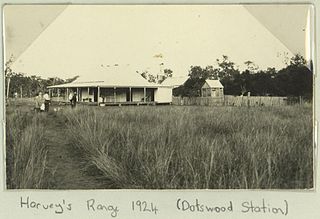
Dotswood is a rural locality in the Charters Towers Region, Queensland, Australia. In the 2021 census, Dotswood had a population of 83 people.
Breddan is a rural locality in the Charters Towers Region, Queensland, Australia. In the 2021 census, Breddan had a population of 478 people.

Broughton is a rural locality in the Charters Towers Region, Queensland, Australia. In the 2021 census, Broughton had a population of 714 people.

Mingela is a rural town and locality in the Charters Towers Region, Queensland, Australia. In the 2021 census, the locality of Mingela had a population of 14 people.
Beach Holm is a coastal locality in the City of Townsville, Queensland, Australia. In the 2021 census, Beach Holm had a population of 35 people.
Granite Vale is a rural locality in the City of Townsville, Queensland, Australia. In the 2021 census, Granite Vale had a population of 8 people.
Calcium is a rural locality in the City of Townsville, Queensland, Australia. In the 2021 census, Calcium had a population of 12 people.
Rangewood is a suburb of Townsville in the City of Townsville, Queensland, Australia. In the 2021 census, Rangewood had a population of 1,084 people.
Hervey Range Developmental Road is a continuous 125-kilometre (78 mi) road route in the Townsville and Charters Towers local government areas of Queensland, Australia. It is designated as State Route 72. It is a state-controlled regional road.
