
The Burdekin River is a river in North and Far North Queensland, Australia. The river rises on the northern slopes of Boulder Mountain at Valley of Lagoons, part of the western slope of the Seaview Range, and flows into the Coral Sea at Upstart Bay over 200 kilometres (124 mi) to the southeast of the source, with a catchment area of approximately 130,000 square kilometres (50,000 sq mi). The Burdekin River is Australia's largest river by (peak) discharge volume.
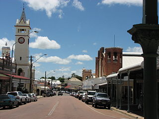
Charters Towers is a rural town in the Charters Towers Region, Queensland, Australia. It is 136 km (85 mi) by road south-west from Townsville on the Flinders Highway. During the last quarter of the 19th century, the town boomed as the rich gold deposits under the city were developed. After becoming uneconomical in the 20th century, profitable mining operations have commenced once again. In the 2016 census, Charters Towers had a population of 8,120 people.

Ayr is a rural town and locality in the Shire of Burdekin, Queensland, Australia. It is the centre of a sugarcane-growing region and the administrative centre for the Burdekin Shire Council. In the 2016 census, the locality of Ayr had a population of 8,738 people.

The Flinders Highway is a highway that crosses Queensland east to west, from Townsville on the Pacific coast to Cloncurry. The road continues as the Barkly Highway from Cloncurry to the Northern Territory border at Camooweal and beyond. The Flinders Highway passes a number of small outback towns and typical outback landscape predominates towards the inland. It was known as National Route 78 before Queensland began to convert to the alphanumeric system being adopted in Australia and is now designated as A6. The highway is also known as Overlanders Way. Its entire length is part of the National Land Transport Network.

Greenvale is a rural town and locality in the Charters Towers Region, Queensland, Australia. In the 2016 census, the locality of Greenvale had a population of 232 people.

Home Hill is a rural town and locality in the Shire of Burdekin, Queensland, Australia. In the 2016 census, the locality of Home Hill had a population of 2,954 people.

North Queensland or the Northern Region is the northern part of the Australian state of Queensland that lies just south of Far North Queensland. Queensland is a massive state, larger than many countries, and its tropical northern part has been historically remote and undeveloped, resulting in a distinctive regional character and identity.

The Shire of Dalrymple was a local government area located in North Queensland, Australia, and surrounded but did not include the town of Charters Towers, at which its council and administrative centre was based. It covered an area of 68,324.5 square kilometres (26,380.2 sq mi), and existed as a local government entity from 1879 until 2008, when it amalgamated with the separate City of Charters Towers to form the Charters Towers Region.

Pentland is a rural town and locality in the Charters Towers Region, Queensland, Australia. In the 2016 census, the locality of Pentland had a population of 306 people.

Townsville City is a coastal suburb at the centre of the City of Townsville, Queensland, Australia. In the 2016 census, the suburb of Townsville City had a population of 2,910 people.

Ravenswood is a rural town and locality in the Charters Towers Region, Queensland, Australia. In the 2016 census, the locality of Ravenswood had a population of 255 people.

Breddan Aerodrome is a heritage-listed abandoned aerodrome at Gregory Developmental Road, Breddan, Charters Towers Region, Queensland, Australia. It is located 15 kilometres (9.3 mi) north of Charters Towers. It was built from 1942 to 1943 by Allied Works Council and Queensland Main Roads Commission. The airfield was constructed for the USAAF 38th Bomb Group in August 1942 as a satellite field for Charters Towers Airport, and later used by the Royal Australian Air Force (RAAF) during World War II as a maintenance base. Consisting of two runways, the airfield was abandoned after 1948. Today, the remains of the airfield consist of some deteriorating runways, taxiways and hardstands, mostly being reclaimed by grassland and shrub. No buildings have survived. It is also known as Breddan Airfield and Breddan WWII Aircraft Maintenance, Repair and Salvage Depot. It was added to the Queensland Heritage Register on 16 April 2010.
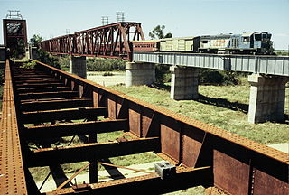
The Great Northern Railway is a 1067 mm gauge railway line in Queensland, Australia. The line stretches nearly 1,000 kilometres linking the port city of Townsville, Australia to the mining town of Mount Isa in north-west Queensland. Along with a passenger service called the Inlander, it is a major freight route connecting the Mount Isa Mines to the Port of Townsville. In 2010, the line moved 5.8 million tonnes of cargo, and this is expected to increase significantly in coming years.
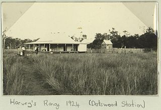
Dotswood is a rural locality in the Charters Towers Region, Queensland, Australia. In the 2016 census Dotswood had a population of 101 people.

Richmond Hill is a suburb of Charters Towers in the Charters Towers Region, Queensland, Australia. In the 2016 census Richmond Hill had a population of 2,488 people.
Breddan is a rural locality in the Charters Towers Region, Queensland, Australia. In the 2016 census, Breddan had a population of 485 people.

Campaspe is a rural locality in the Charters Towers Region, Queensland, Australia. In the 2021 census, Campaspe had a population of 123 people.

Broughton is a rural locality in the Charters Towers Region, Queensland, Australia. In the 2016 census, Broughton had a population of 726 people.

Mingela is a rural town and locality in the Charters Towers Region, Queensland, Australia. In the 2021 census, the locality of Mingela had a population of 14 people.
