
Garbutt is a suburb of Townsville in the City of Townsville, Queensland, Australia. It is home to the Townsville International Airport and RAAF Townsville. In the 2021 census, Garbutt had a population of 2,309 people.

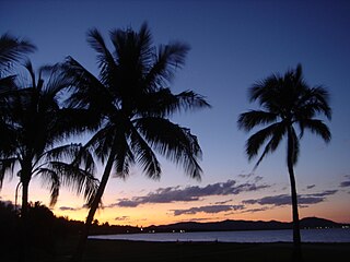
Picnic Bay is a town and suburb of Magnetic Island in the City of Townsville, Queensland, Australia. It is named for the bay on the southernmost corner of Magnetic Island where the town is situated. In the 2021 census, the suburb of Picnic Bay had a population of 367 people.

Arcadia is a coastal suburb on Magnetic Island in the City of Townsville, Queensland, Australia. In the 2021 census, Arcadia had a population of 246 people.

Belgian Gardens is an inner coastal suburb of Townsville in the City of Townsville, Queensland, Australia. In the 2021 census, Belgian Gardens had a population of 2,073 people.

South Townsville is a coastal suburb of Townsville in the City of Townsville, Queensland, Australia. In the 2021 census, South Townsville had a population of 2,424 people.
Rowes Bay is a suburb of Townsville in the City of Townsville, Queensland, Australia. In the 2021 census, Rowes Bay had a population of 541 people.

Bushland Beach is a coastal suburb in the northern beaches area of Townsville in the City of Townsville, Queensland, Australia. In the 2021 census, Bushland Beach had a population of 6,641 people.

North Ward is a coastal suburb of Townsville in the City of Townsville, Queensland, Australia. In the 2021 census, North Ward had a population of 5,073 people.
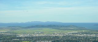
The Cape Pallarenda Conservation Park is a protected conservation park located 10 kilometres (6.2 mi) north-east of Townsville in the Far North region of Queensland, Australia. The 44-hectare (110-acre) regional park is located within the suburb of Pallarenda.

Cluden is an outer southern suburb of Townsville in the City of Townsville, Queensland, Australia. In the 2021 census, Cluden had a population of 413 people.

Bluewater is a town and coastal suburb in the City of Townsville, Queensland, Australia. In the 2021 census, the suburb of Bluewater had a population of 1,085 people.
Saunders Beach is a coastal town and suburb of Townsville in the City of Townsville, Queensland, Australia. In the 2021 census, the suburb of Saunders Beach had a population of 385 people.

Yabulu is a town and coastal suburb in the City of Townsville, Queensland, Australia. In the 2021 census, the suburb of Yabulu had a population of 719 people.

Rollingstone is a rural town and coastal locality in the City of Townsville, Queensland, Australia. In the 2021 census, the locality of Rollingstone had a population of 133 people.

Balgal Beach is a coastal suburb and a beach in the City of Townsville, Queensland, Australia. The town of Balgal is within the locality. In the 2021 census, Balgal Beach had a population of 998 people.

Cape Cleveland is a rural locality in the City of Townsville, Queensland, Australia. In the 2021 census, Cape Cleveland had a population of 128 people.

Mount St John is an industrial suburb of Townsville in the City of Townsville, Queensland, Australia. In the 2021 census, Mount St John had a population of 103 people.

Town Common is a coastal suburb of Townsville in the City of Townsville, Queensland, Australia. In the 2021 census, Town Common had "no people or a very low population".

Florence Bay is a suburb of Magnetic Island in the City of Townsville, Queensland, Australia. In the 2021 census, Florence Bay had "no people or a very low population".
West Point is an island town and suburb of Magnetic Island in the City of Townsville, Queensland, Australia. In the 2021 census, the suburb of West Point had a population of 32 people.

