Florence Bay, Queensland

Last updated

Map all coordinates using: OpenStreetMap
Florence Bay
Magnetic Island,  Queensland
Florence Bay, Magnetic Island, 2006 01.jpg
Australia Queensland location map.svg
Red pog.svg
Florence Bay
Coordinates 19°07′10″S146°52′19″E / 19.1194°S 146.8719°E / -19.1194; 146.8719 (Florence Bay (centre of suburb))
Population0 (SAL 2016) [1] [2]
Area3.5 km2 (1.4 sq mi)
Time zone AEST (UTC+10:00)
LGA(s) City of Townsville
State electorate(s) Townsville
Federal division(s) Herbert
Suburbs around Florence Bay:
Coral Sea Coral Sea Coral Sea
Horseshoe Bay Florence Bay Coral Sea
Horseshoe Bay Arcadia Coral Sea

Florence Bay is a suburb of Magnetic Island in the City of Townsville, Queensland, Australia. [3] In the 2021 census, Florence Bay had a population of 0 people. [4]

Contents

Geography

Florence Bay is on the north-east of Magnetic Island. Its rugged coastline creates a number of bays and headlands; the named features are:

The Forts is a mountain ( 19°07′23″S146°52′14″E / 19.1230°S 146.8705°E / -19.1230; 146.8705 (The Forts (mountain & command post)) ) which rises to 182 metres (597 ft) above sea level. [7]

Almost all of the locality, apart from a small area near the beach at Radical Bay, is within the Magnetic Island National Park. [8]

History

Remains of Gun Emplacement Magnetic Island Remains of Gun Emplacement Florence Bay at Rear.jpg
Remains of Gun Emplacement

Florence Bay was once the site of a private guesthouse reachable only by boat. One of these vessels, The 'Magnet' was carrying a picnic party from Florence Bay when it struck a reef on 25 March 1917 and was subsequently sunk. [9]

After the demise of the guesthouse (reputably due to cyclone damage - unable to verify this), the property passed into the care of the Scout Association. It became the main youth training facility in North Queensland.[ citation needed ]

A group within the Scout Association was recognised for their work to develop the facilities - including a storehouse, pump and well, parade ground, camping area and secluded chapel - by being awarded the title "Florence Bay Rover Crew". It is notable that much of their work was done by hand, including carrying bricks, cement, timber and equipment on their backs from either the main road or Radical Bay moorings.[ citation needed ]

The chapel, set high on the hillside, is consecrated and contains the cremated remains of one of North Queensland's most notable early Scouting leaders, "Beaver" Masters.[ citation needed ]

On the headland at the south end of Florence Bay there remains the base of a World War II searchlight tower, along with a command and anti-aircraft installation at The Forts above the bay. [10]

Demographics

In the 2016 census, Florence Bay had a population of 0 people. [11]

In the 2021 census, Florence Bay had a population of 0 people. [4]

Attractions

View from Forts to Florence Bay Magnetic Island View from Forts to Florence Bay.jpg
View from Forts to Florence Bay

The Forts Walk is a walking track in the Magnetic Island National Park with a number of points of interests: [12]

Education

There are no schools in Florence Bay. The nearest primary school is in Nelly Bay on the island. The nearest secondary school is Townsville State High School in Railway Estate in the Townsville mainland. [8]

Related Research Articles

<span class="mw-page-title-main">Magnetic Island</span> Island off the coast of Queensland, Australia

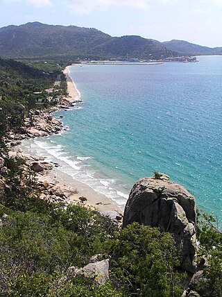
Magnetic Island is an island 8 kilometres (5 mi) offshore from the city of Townsville, Queensland, Australia. This 52 km2 (20.1 sq mi) mountainous island in Cleveland Bay has effectively become a suburb of Townsville, with 2,335 permanent residents. The island is accessible from Townsville Breakwater to Nelly Bay Harbour by ferry. There is a large 39.5 km2 (15.3 sq mi) National Park and bird sanctuary and walking tracks can be taken between the populated bays and to a number of tourist destinations such as the World War II forts.

<span class="mw-page-title-main">Garbutt, Queensland</span> Suburb of Townsville, Queensland, Australia

Garbutt is a suburb of Townsville in the City of Townsville, Queensland, Australia. It is home to the Townsville International Airport and RAAF Townsville.

<span class="mw-page-title-main">Picnic Bay, Queensland</span> Town in Queensland, Australia

Picnic Bay is a town and suburb of Magnetic Island in the City of Townsville, Queensland, Australia. In the 2016 census, Picnic Bay had a population of 291 people. It is named for the bay on the southernmost corner of Magnetic Island where the town is situated.

<span class="mw-page-title-main">Nelly Bay, Queensland</span> Suburb of Magnetic Island, Queensland, Australia

Nelly Bay is a town on Magnetic Island and a suburb of the City of Townsville, Queensland, Australia. In the 2016 census, Nelly Bay had a population of 1,196 people. A tourism hub on the island, it is especially significant as the site of the ferry terminal, which links it to Townsville.

<span class="mw-page-title-main">Arcadia, Queensland</span> Suburb of Magnetic Island, Queensland, Australia

Arcadia is a coastal suburb on Magnetic Island in the City of Townsville, Queensland, Australia. In the 2016 census, Arcadia had a population of 248 people.

Stuart is a rural coastal suburb in the City of Townsville, Queensland, Australia. In the 2016 census, Stuart had a population of 1,386 people.

<span class="mw-page-title-main">Horseshoe Bay, Queensland</span> Town in Queensland, Australia

Horseshoe Bay is a bay, town and suburb on Magnetic Island in the City of Townsville, Queensland, Australia. It is a major tourist accommodation and recreation centre on the island. In the 2016 census, the suburb of Horseshoe Bay had a population of 578 people.

<span class="mw-page-title-main">Railway Estate, Queensland</span> Suburb of Townsville, Queensland, Australia

Railway Estate is a suburb of Townsville in the City of Townsville, Queensland, Australia. In the 2016 census Railway Estate had a population of 2,852 people.

<span class="mw-page-title-main">Rowes Bay, Queensland</span> Suburb of Townsville, Queensland, Australia

Rowes Bay is a suburb of Townsville in the City of Townsville, Queensland, Australia. In the 2016 census, Rowes Bay had a population of 573 people.

<span class="mw-page-title-main">Deeragun, Queensland</span> Suburb of Townsville, Queensland, Australia

Deeragun is an outer western town and suburb of Townsville in the City of Townsville, Queensland, Australia. In the 2016 census, Deeragun had a population of 4,250 people.

<span class="mw-page-title-main">Thuringowa Central, Queensland</span> Suburb of Townsville, Queensland, Australia

Thuringowa Central is a suburb of Townsville in the City of Townsville, Queensland, Australia. In the 2016 census Thuringowa Central had a population of 2,023 people.

<span class="mw-page-title-main">North Ward, Queensland</span> Suburb of Townsville, Queensland, Australia

North Ward is a coastal suburb of Townsville in the City of Townsville, Queensland, Australia. In the 2016 census, North Ward had a population of 5,065 people.

<span class="mw-page-title-main">Cockle Bay (Queensland)</span> Suburb of Magnetic Island, Queensland, Australia

Cockle Bay is a small bay within the locality of Picnic Bay on south-western corner of Magnetic Island, City of Townsville, Queensland, Australia.

<span class="mw-page-title-main">Magnetic Battery</span>

The Magnetic Battery, Fort War or The Forts, as it is commonly referred, is a former Royal Australian Navy artillery battery in the hinterland of Horseshoe. Florence and Arthur Bays on Magnetic Island. Built in 1942/1943, the battery operated from July 1943 until the end of World War II. The remains of the facility are now maintained by Queensland Parks and Wildlife Service as part of the Magnetic Island National Park and are open to visitors year round.

<span class="mw-page-title-main">Balgal Beach, Queensland</span> Suburb of Townsville, Queensland, Australia

Balgal Beach is a coastal suburb and a beach in the City of Townsville, Queensland, Australia. The town of Balgal is within the locality. In the 2021 census, Balgal Beach had a population of 998 people.

<span class="mw-page-title-main">Currajong, Queensland</span> Suburb of Townsville, Queensland, Australia

Currajong is a suburb in the City of Townsville, Queensland, Australia. In the 2016 census, Currajong had a population of 2,548 people.

<span class="mw-page-title-main">Fort Complex, Magnetic Island</span> Historic site in Queensland, Australia

The Fort Complex is a heritage-listed fortification at Magnetic Island National Park, east side of Magnetic Island, City of Townsville, Queensland, Australia. It was built in 1943. It was added to the Queensland Heritage Register on 21 October 1992.

Mount Low is a suburb of Townsville in the City of Townsville, Queensland, Australia. In the 2016 census, Mount Low had a population of 4,655 people.

West Point is an island town and suburb of Magnetic Island in the City of Townsville, Queensland, Australia. In the 2016 census the suburb of West Point had a population of 32 people.

<span class="mw-page-title-main">Burdell, Queensland</span> Suburb of Townsville, Queensland, Australia

Burdell is a suburb of Townsville in the City of Townsville, Queensland, Australia. In the 2021 census, Burdell had a population of 7,171 people.

References

  1. Australian Bureau of Statistics (27 June 2017). "Florence Bay (Suburb and Locality)". Australian Census 2016.  OOjs UI icon edit-ltr-progressive.svg
  2. Australian Bureau of Statistics (27 June 2017). "Florence Bay (Suburb and Locality)". Australian Census 2016 QuickStats. Retrieved 28 June 2022.  OOjs UI icon edit-ltr-progressive.svg
  3. "Florence Bay – suburb in City of Townsville (entry 44593)". Queensland Place Names. Queensland Government . Retrieved 29 December 2020.
  4. 1 2 Australian Bureau of Statistics (28 June 2022). "Florence Bay (SAL)". 2021 Census QuickStats. Retrieved 28 February 2023. OOjs UI icon edit-ltr-progressive.svg
  5. 1 2 3 4 5 6 7 "Bays - Queensland". Queensland Open Data. Queensland Government. 12 November 2020. Archived from the original on 25 November 2020. Retrieved 25 November 2020.
  6. "White Lady Rock – rock in City of Townsville (entry 37289)". Queensland Place Names. Queensland Government . Retrieved 1 August 2023.
  7. 1 2 "Mountain peaks and capes - Queensland". Queensland Open Data. Queensland Government. 12 November 2020. Archived from the original on 25 November 2020. Retrieved 25 November 2020.
  8. 1 2 "Queensland Globe". State of Queensland . Retrieved 1 August 2023.
  9. "SHIPWRECKS - View". www.environment.gov.au. Archived from the original on 1 March 2019. Retrieved 29 April 2019.
  10. "MAGNETIC ISLAND TOWNSVILLE, QLD DURING WWII". Australia@War. Archived from the original on 1 August 2023. Retrieved 1 August 2023.
  11. Australian Bureau of Statistics (27 June 2017). "Florence Bay (SSC)". 2016 Census QuickStats. Retrieved 20 October 2018. OOjs UI icon edit-ltr-progressive.svg
  12. "Forts Walk | Magnetic Island National Park". Parks and forests. Queensland Government. 27 July 2022. Archived from the original on 7 June 2023. Retrieved 1 August 2023.
  13. 1 2 3 "Tourist points - Queensland". Queensland Open Data. Queensland Government. 18 November 2020. Archived from the original on 24 November 2020. Retrieved 24 November 2020.