
Annandale is a south-western suburb of Townsville in the City of Townsville, Queensland, Australia. In the 2021 census, Annandale had a population of 8,376 people.

Garbutt is a suburb of Townsville in the City of Townsville, Queensland, Australia. It is home to the Townsville International Airport and RAAF Townsville. In the 2021 census, Garbutt had a population of 2,309 people.

Aitkenvale is a suburb of Townsville in the City of Townsville, Queensland, Australia. In the 2021 census, Aitkenvale had a population of 4,797 people.
Hyde Park is a suburb in the City of Townsville, Queensland, Australia. In the 2021 census, Hyde Park had a population of 1,374 people.
Vincent is a suburb of Townsville in the City of Townsville, Queensland, Australia.
Wulguru is an outer southern suburb of Townsville in the City of Townsville, Queensland, Australia. In the 2021 census, Wulguru had a population of 4,389 people.
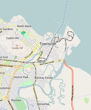
West End is an inner suburb of Townsville in the City of Townsville, Queensland, Australia. In the 2021 census, West End had a population of 3,891 people.

Belgian Gardens is an inner coastal suburb of Townsville in the City of Townsville, Queensland, Australia. In the 2021 census, Belgian Gardens had a population of 2,073 people.

South Townsville is a coastal suburb of Townsville in the City of Townsville, Queensland, Australia. In the 2021 census, South Townsville had a population of 2,424 people.
Railway Estate is a suburb of Townsville in the City of Townsville, Queensland, Australia. In the 2021 census, Railway Estate had a population of 2,871 people.

Deeragun is a town and outer western suburb of Townsville in the City of Townsville, Queensland, Australia. In the 2021 census, the suburb of Deeragun had a population of 4,273 people.
Mundingburra is a suburb of Townsville in the City of Townsville, Queensland, Australia. In the 2021 census, Mundingburra had a population of 3,594 people.

Idalia is a southern suburb in the City of Townsville, Queensland, Australia. In the 2021 census, Idalia had a population of 4,563 people.

Rasmussen is a suburb of Townsville in the City of Townsville, Queensland, Australia. In the 2021 census, Rasmussen had a population of 4,669 people.

North Ward is a coastal suburb of Townsville in the City of Townsville, Queensland, Australia. In the 2021 census, North Ward had a population of 5,073 people.
Cranbrook is a suburb of Townsville in the City of Townsville, Queensland, Australia. In the 2021 census, Cranbrook had a population of 5,844 people.

Mount St John is an industrial suburb of Townsville in the City of Townsville, Queensland, Australia. In the 2021 census, Mount St John had a population of 103 people.
Currajong is a suburb in the City of Townsville, Queensland, Australia. In the 2021 census, Currajong had a population of 2,490 people.
Cosgrove is a suburb of Townsville in the City of Townsville, Queensland, Australia. In the 2021 census, Cosgrove had a population of 665 people.

Bohle is a northern suburb in the City of Townsville, Queensland, Australia. In the 2021 census, Bohle had a population of 121 people.


