Bunbury is a coastal city in the Australian state of Western Australia, approximately 175 kilometres (109 mi) south of the state capital, Perth. It is the state's third most populous city after Perth and Mandurah, with a population of approximately 75,000.
The South West region is one of the nine regions of Western Australia. It has an area of 23,970 km2, and a population of about 170,000 people. Bunbury is the main city in the region.

Boyanup is a town on the South Western Highway in the South West agricultural region, 195 km south of Perth and 18 km south-east of Bunbury, Western Australia. The town is located on the Preston River.

South Western Highway is a highway in the South West region of Western Australia connecting Perth's southeast with Walpole. It is a part of the Highway 1 network for most of its length. It is about 406 kilometres (252 mi) long.
The electoral district of Capel was a Legislative Assembly electorate in the state of Western Australia. The district was named for the South West town of Capel, located between Bunbury and Busselton, which fell within its borders. The seat was abolished after only one term at the 2007 redistribution, taking effect from the 2008 election due to the one vote one value legislation. Most parts of the seat now fall within the new seat of Collie-Preston, which is regarded as a marginal Labor seat by Antony Green based on 2005 figures, with the Busselton portions becoming part of Vasse.

Collie-Preston is a Legislative Assembly electorate in the state of Western Australia. While the seat was known as Collie for just over a century of its existence as an electorate, the seat was known as South West Mining from 1901 to 1904, and Collie-Wellington from 2005 to 2008. It is named for the South West coal mining town of Collie. While historically a very safe seat for the Labor Party, redistributions in 1988 and 2007 due to increases in the quota for country seats which had historically been malapportioned resulted in the seat incorporating surrounding rural shires which were hostile to Labor and thereby becoming more marginal.
Mitchell was an electoral district of the Legislative Assembly in the Australian state of Western Australia. It existed from 1983 to 2005 and, under the name Leschenault, continued until 2008.

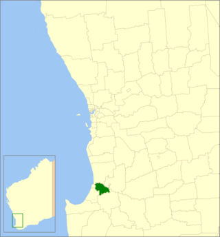
The Shire of Capel is a local government area in the South West region of Western Australia, taking in the land between the cities of Bunbury and Busselton about 200 kilometres (124 mi) south of the state capital, Perth. The Shire covers an area of 557.6 square kilometres (215.3 sq mi), and its seat of government is the town of Capel.
The Shire of Dardanup is a local government area in the South West region of Western Australia, immediately to the east and southeast of the City of Bunbury and about 180 kilometres (112 mi) south of the state capital, Perth. The Shire covers an area of 526.6 square kilometres (203.3 sq mi), and its seat of government is in Eaton in Bunbury's eastern suburbs.
Bunbury Airport is an airport servicing the Western Australian city of Bunbury. Bunbury Airport is located 8 km (5 mi) south-east of the city centre and is the only airport serving the city. The airport is used largely as a facility for General Aviation, pilot training and emergency services. Bunbury Airport serves an area that includes the City of Bunbury and the surrounding districts of Harvey, Dardanup, Capel and Donnybrook-Balingup.
The South West Football League is an Australian rules football league based in the south-west of Western Australia. The league is affiliated to Country Football WA, formerly known as the West Australian Country Football League.

Peppermint Grove Beach is a residential subdivision and beachside town in the South West region of Western Australia. Its local government area is the Shire of Capel and it is located 8 kilometres (5 mi) northwest of Capel on the Geographe Bay coast near the Capel River mouth.
Dean Turner is a former Australian rules footballer who played with Fitzroy and the West Coast Eagles in the Victorian/Australian Football League (VFL/AFL).
Ferguson River is a river in the South West region of Western Australia.

Wellington Mill is a locality in the Ferguson River valley, in the Greater Bunbury sub-region of South West region of Western Australia.
The Donnybrook Football Club is an Australian rules football club which competes in the South West Football League in the South West corner of Western Australia.
The South Western Times is a weekly English language newspaper published for Bunbury and the South West region in Western Australia.

The Northcliffe Branch, also known as the Northcliffe Section or Picton to Northcliffe Line, is the railway route between Picton and Northcliffe in Western Australia.