
The local government areas of Western Australia (LGAs) are those areas, towns and districts in Western Australia that manage their own affairs to the extent permitted by the Local Government Act 1995. The Local Government Act 1995 also makes provision for regional local governments (referred to as "regional councils", established by two or more local governments for a particular purpose.
Bunbury is a coastal city in the Australian state of Western Australia, approximately 175 kilometres (109 mi) south of the state capital, Perth. It is the state's third most populous city after Perth and Mandurah, with a population of approximately 75,000.

The City of Wanneroo is a local government area with city status in the northern suburbs of Perth, Western Australia. It is centred approximately 25 kilometres (15.5 mi) north of Perth's central business district and forms part of the northern boundary of the Perth metropolitan area. Wangara encompasses the federal divisions of Cowan, Moore and Pearce.

The Peel region is one of the nine regions of Western Australia. It is located on the west coast of Western Australia, about 75 km (47 mi) south of the state capital, Perth. It consists of the City of Mandurah, and the Shires of Boddington, Murray, Serpentine-Jarrahdale and Waroona.

Boyanup is a town on the South Western Highway in the South West agricultural region, 195 km south of Perth and 18 km south-east of Bunbury, Western Australia. The town is located on the Preston River.

Pinjarra is a town in the Peel region of Western Australia along the South Western Highway, 82 kilometres (51 mi) from the state capital, Perth and 21 kilometres (13 mi) south-east of the coastal city of Mandurah. Its local government area is the Shire of Murray. At the 2016 census, Pinjarra had a population of 4910.

Brunswick Junction is a town in the South West of Western Australia, situated along the South Western Highway between Harvey and Bunbury. It had a population of 772 people at the 2016 census, down from 797 at the 2006 census.

Cookernup is a town in the South West of Western Australia near the South Western Highway, between Waroona and Harvey.

Harvey is a town located in the South West of Western Australia along the South Western Highway, 140 kilometres (87 mi) south of Perth, between Pinjarra and Bunbury. It has a population of 2,750. Harvey Town is known for its dairy industry and oranges.

Serpentine is a town located 55 kilometres (34 mi) south-southeast of Perth, the capital of Western Australia, and 7 km south of Mundijong.

Australind is a town in Western Australia, located 12 km north-east of Bunbury's central business district. Its local government area is the Shire of Harvey. At the 2016 census, Australind had a population of 14,539.
Greater Perth is Perth's Greater Capital City Statistical Area (GCCSA), a geographical area designed to represent the functional extent of Western Australia's (WA) capital city.

Preston Beach is a small town located in the Peel region of Western Australia just off the Forrest Highway, between Mandurah and Bunbury in the Yalgorup National Park.

The City of Bunbury is a local government area in the South West region of Western Australia, covering an area of 65.7 square kilometres (25.4 sq mi) along the coast about 180 kilometres (112 mi) south of Perth, the capital of Western Australia. The City of Bunbury is one of four local governments comprising the Greater Bunbury sub-region. As at the 2016 Census, the City of Bunbury had an estimated population of almost 32,000.

The South Western Railway, also known as the South West Main Line, is the main railway route between Perth and Bunbury in Western Australia.

Bayswater is a suburb 6 km (4 mi) north-east of the central business district (CBD) of Perth, the capital of Western Australia. It is just north of the Swan River, within the City of Bayswater local government area. It is predominantly a low-density residential suburb consisting of single-family detached homes. However, there are several clusters of commercial buildings, most notably in the suburb's town centre, around the intersection of Whatley Crescent and King William Street and a light industrial area in the suburb's east.
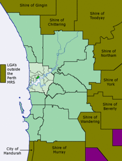
The Metropolitan Region Scheme (MRS) provides the legal basis for future land use planning throughout the Perth metropolitan region. It classifies land into broad zones and reservations and is administered by the Western Australian Planning Commission. It is one of three regional schemes in Western Australia. The MRS is updated via an ongoing process of amendments. Amendments to the MRS are typically informed by a series of strategic plans prepared by the Department of Planning, Lands and Heritage. Detailed land use planning within the area of the MRS is undertaken by local governments and other statutory authorities which prepare one or more local planning schemes within their administrative boundaries. Local plannings schemes must be consistent with the MRS and require the approval of the WAPC. The acquisition of land reserved under the MRS is funded by a hypothecated land tax called the Metropolitan Region Improvement Tax.
Gordon Stephenson was a British-born town planner and architect. He is best known for his role in shaping the modern growth and development of Perth, Western Australia.

The Shire of Capel is a local government area in the South West region of Western Australia, taking in the land between the cities of Bunbury and Busselton about 200 kilometres (124 mi) south of the state capital, Perth. The Shire covers an area of 557.6 square kilometres (215.3 sq mi), and its seat of government is the town of Capel.

Transperth Train Operations is a division of the Public Transport Authority of Western Australia. It is responsible for operating Perth’s urban passenger rail system, as part of the Transperth network.

