
The City of Cockburn is a local government area in the southern suburbs of the Western Australian capital city of Perth about 8 kilometres (5 mi) south of Fremantle and about 24 kilometres (15 mi) south of Perth's central business district. The City covers an area of 167.5 square kilometres (64.7 sq mi) and had a population of over 104,000 as at the 2016 Census.

The Town of Victoria Park is a local government area of Western Australia. It covers an area of 17.62 km² in metropolitan Perth, the capital of Western Australia. It had a population of approximately 35,000 as at the 2016 census.

Busselton is a city in the South West region of the state of Western Australia approximately 220 km (140 mi) south-west of Perth. Busselton has a long history as a popular holiday destination for Western Australians; however, the closure of the Busselton Port in 1972 and the contemporaneous establishment of the nearby Margaret River wine region have seen tourism become the dominant source of investment and development, supplemented by services and retail. The city is best known for the Busselton Jetty, the longest wooden jetty in the Southern Hemisphere.

Collie is a town in the South West region of Western Australia, 213 kilometres (132 mi) south of the state capital, Perth, and 59 kilometres (37 mi) inland from the regional city and port of Bunbury. It is near the junction of the Collie and Harris Rivers, in the middle of dense jarrah forest and the only coalfields in Western Australia. At the 2021 census, Collie had a population of 7,599.

The Shire of Augusta Margaret River is a local government area in the south-west corner of the South West region of Western Australia, approximately 270 kilometres (168 mi) south of Perth. The shire covers an area of 2,243 square kilometres (866 sq mi) and had a population of over 14,000 at the 2016 Census, about half of whom live in the towns of Margaret River and Augusta.
The Shire of Ashburton is one of the four local government areas in the Pilbara region of Western Australia, covering an area of 105,647 square kilometres (40,791 sq mi). It is named after the Ashburton River.

The Shire of West Arthur is a local government area in the Wheatbelt region of Western Australia, generally to the west of Albany Highway about 200 kilometres (124 mi) south-east of Perth, the state capital. The Shire covers an area of 2,834 square kilometres (1,094 sq mi) and its seat of government is the town of Darkan. Industries within the Shire, worth approximately $45 million per year to the State's economy, are dominated by wool and sheep, and also include timber, grain, forestry, beef, pigs, cattle hide tanning, engineering and earthmoving.

The Shire of Upper Gascoyne is a local government area in the Gascoyne region of Western Australia, inland from Carnarvon and about 1,000 kilometres (620 mi) north of the state capital, Perth. The Shire has an area of 57,939 square kilometres (22,370 sq mi), much of which is uninhabited land or sparsely vegetated sheep station country, and its seat of government is the small town of Gascoyne Junction. It has a population of 170, 56% of whom identify as Aboriginal.

The Shire of Mount Marshall is a local government area in the Wheatbelt region of Western Australia, about 80 kilometres (50 mi) north-northwest of Merredin and about 300 kilometres (186 mi) northeast of the state capital, Perth. The Shire covers an area of 10,190 square kilometres (3,934 sq mi), and its seat of government is the town of Bencubbin.

The Shire of Derby–West Kimberley is one of four local government areas in the Kimberley region of northern Western Australia, covering an area of 104,080 square kilometres (40,186 sq mi), most of which is sparsely populated. The Shire's population as at the 2016 Census was almost 8,000, with most residing in the major towns of Derby, which is also the Shire's seat of government, and Fitzroy Crossing. There are also around 70 Aboriginal communities within the Shire.

Mapoon is a coastal town in the Aboriginal Shire of Mapoon and a locality split between the Aboriginal Shire of Mapoon and the Shire of Cook in Queensland, Australia. In the 2021 census, the locality of Mapoon had a population of 469 people.

The City of Mandurah is a local government area of Western Australia, covering both Mandurah proper and an additional area reaching down as far south as Lake Clifton. The city has a total area of approximately 174 square kilometres (67 sq mi).
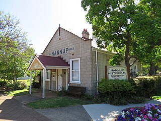
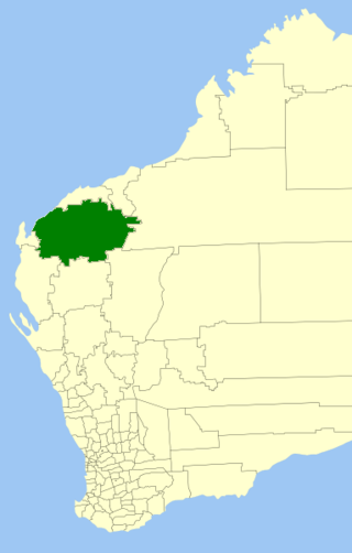
The Shire of Nannup is a local government area in the South West region of Western Australia, approximately 280 kilometres (174 mi) south of the state capital, Perth and 60 kilometres (37 mi) southeast of the coastal resort town of Busselton. Its seat of government is the town of Nannup, where about half of the Shire's population reside.

The Shire of Dandaragan is a local government area located in the Wheatbelt region of Western Australia, about 200 kilometres (124 mi) north of the state capital, Perth. The Shire covers an area of 6,716 square kilometres (2,593 sq mi) and its seat of government is the town of Jurien Bay.

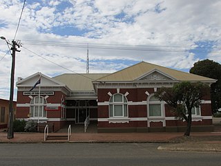
The Shire of Collie is a local government area in the South West region of Western Australia, about 60 kilometres (37 mi) east of Bunbury and about 200 kilometres (124 mi) south of the state capital, Perth. The Shire covers an area of 1,711 square kilometres (661 sq mi), and its seat of government is the town of Collie.

The Shire of Jerramungup is a local government area in the Great Southern region of Western Australia, about 180 kilometres (112 mi) northeast of Albany and about 440 kilometres (273 mi) southeast of the state capital, Perth. The Shire covers an area of 6,507 square kilometres (2,512 sq mi) with Bremer Bay its largest town. The seat of government is the town of Jerramungup.

The Shire of Meekatharra is a local government area in the Mid West region of Western Australia, about halfway between the town of Port Hedland and the state capital, Perth, Western Australia. The Shire covers an area of 100,789 square kilometres (38,915 sq mi), and its seat of government is the town of Meekatharra.
The Shire of Ravensthorpe is a local government area in the Great Southern region of Western Australia, about halfway between the city of Albany and the town of Esperance and about 530 kilometres (329 mi) southeast of the state capital, Perth. The Shire covers an area of 13,551 square kilometres (5,232 sq mi), and its seat of government is the town of Ravensthorpe.

The Carbunup River is located in the south-west corner of Western Australia. The mouth of the Carbunup River is approximately 20 kilometres (12 mi) west of Busselton where the river flows into Geographe Bay.

Munglinup is a small town located in the Shire of Ravensthorpe in the Goldfields–Esperance region of Western Australia.


