
The City of Stirling is a local government area in the northern suburbs of the Western Australian capital city of Perth about 10 kilometres (6 mi) north of Perth's central business district. The City covers an area of 105.2 square kilometres (40.6 sq mi) and has a population of over 223,000, making it the largest local government area by population in Western Australia.

The City of Bayswater is a local government area in the Western Australian capital city of Perth, about 7 kilometres (4 mi) northeast of Perth's central business district. The city covers an area of 34.6 square kilometres (13.4 sq mi) and had a population of 69,283 as at the 2021 Census. The City of Bayswater is a member of the Eastern Metropolitan Regional Council.

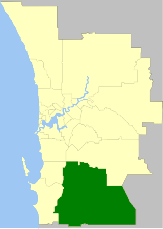
The City of Cockburn is a local government area in the southern suburbs of the Western Australian capital city of Perth about 8 kilometres (5 mi) south of Fremantle and about 24 kilometres (15 mi) south of Perth's central business district. The City covers an area of 167.5 square kilometres (64.7 sq mi) and had a population of over 104,000 as at the 2016 Census.

The City of Kwinana is a local government area of Western Australia. It covers an area of approximately 118 square kilometres in metropolitan Perth, and lies about 38 km south of Perth central business district, via the Kwinana Freeway. Kwinana maintains 287 km of roads and had a population of almost 39,000 as at the 2016 Census.
The Shire of Serpentine-Jarrahdale is a local government area in the outer southeastern metropolitan area of Perth, the capital of Western Australia, and has an area of 905 square kilometres (349 sq mi) and a population of 32,173 as at the 2021 Census. Despite being named after two towns in the area neither Serpentine nor Jarrahdale function as either the Shire's largest settlement (Byford) or the seat of government (Mundijong).

The City of Vincent is a local government area of Western Australia. It covers an area of approximately 10.4 square kilometres (4.0 sq mi) in metropolitan Perth, the capital of Western Australia, and lies about 3 km from the Perth CBD. The City of Vincent maintains 139 km of roads and 104 ha of parks and gardens. It had a population of over 33,000 at the 2016 Census.
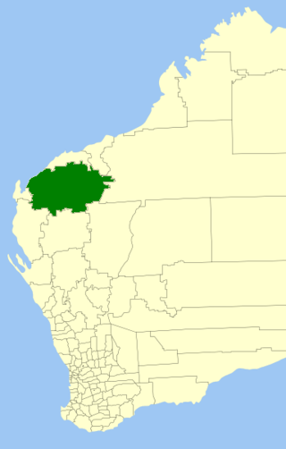
The Shire of Ashburton is one of the four local government areas in the Pilbara region of Western Australia, covering an area of 105,647 square kilometres (40,791 sq mi). It is named after the Ashburton River.

The Shire of Wongan–Ballidu is a local government area in the Wheatbelt region of Western Australia, about 180 kilometres (112 mi) NNE of Perth, the state capital. The Shire covers an area of 3,369 square kilometres (1,301 sq mi) and its seat of government is the town of Wongan Hills. The shire includes the Wongan Hills, after which the town is named.

The Shire of Mount Marshall is a local government area in the Wheatbelt region of Western Australia, about 80 kilometres (50 mi) north-northwest of Merredin and about 300 kilometres (186 mi) northeast of the state capital, Perth. The Shire covers an area of 10,190 square kilometres (3,934 sq mi), and its seat of government is the town of Bencubbin.

The Shire of Donnybrook Balingup is a local government area in the South West region of Western Australia, about 35 kilometres (22 mi) southeast of Bunbury and about 220 kilometres (137 mi) south of the state capital, Perth. The Shire covers an area of about 1,560 square kilometres (602 sq mi), and its seat of government is the town of Donnybrook.

The Shire of Kent is a local government area in the Great Southern region of Western Australia, about 320 kilometres (200 mi) southeast of Perth, the state capital. The Shire covers an area of 5,634 square kilometres (2,175 sq mi) and its seat of government is the town of Nyabing. The area produces grains such as wheat, barley and legumes.

The Shire of Waroona is a local government area in the Peel region of Western Australia between Mandurah and Harvey and about 110 kilometres (68 mi) south of Perth, the state capital. The Shire covers an area of about 835 km² (322 mi²) and its seat of government is the town of Waroona.

The Shire of Wagin is a local government area in the Wheatbelt region of Western Australia, about 230 kilometres (143 mi) southeast of the state capital, Perth. The Shire covers an area of about 1,948 square kilometres (752 sq mi), and its seat of government is the town of Wagin.

The Town of Port Hedland is a local government area in the Pilbara region of Western Australia containing the twin settlements of Port Hedland and South Hedland and the industrial precinct of Wedgefield. It had a population of approximately 14,500 as at the 2016 Census of which only a few hundred live outside the settlement boundaries.

The Shire of Dundas is a local government area in the Goldfields-Esperance region of Western Australia. The shire covers an area of 93,179 square kilometres (35,977 sq mi) and its seat of government is the town of Norseman. Its territory lies between Norseman and the border with South Australia, and is between 700 and 1,500 kilometres east of the state capital, Perth.

The City of Bunbury is a local government area in the South West region of Western Australia, covering an area of 65.7 square kilometres (25.4 sq mi) along the coast about 180 kilometres (112 mi) south of Perth, the capital of Western Australia. The City of Bunbury is one of four local governments comprising the Greater Bunbury sub-region. As at the 2016 Census, the City of Bunbury had an estimated population of almost 32,000.

The Town of Bassendean is a local government area in the northeastern suburbs of the Western Australian capital city of Perth, 6 kilometres (4 mi) west of the industrial centre of Midland and about 12 kilometres (7 mi) northeast of Perth's central business district. The Town covers an area of 10.4 square kilometres (4.0 sq mi), maintains 97 km of roads and had a population of approximately 15,000 as at the 2016 Census. The Town of Bassendean is a member of the Eastern Metropolitan Regional Council.

The City of Rockingham is a council and local government area, comprising the south coastal suburbs of the Western Australian capital city of Perth.

The Shire of Boyup Brook is a local government area located in the South West region of Western Australia, about 270 kilometres (168 mi) southeast of Perth, the state capital. The Shire covers an area of 2,829 square kilometres (1,092 sq mi) and its seat of government is the town of Boyup Brook.
The Shire of Ravensthorpe is a local government area in the southern Goldfields-Esperance region of Western Australia, about halfway between the city of Albany and the town of Esperance and about 530 kilometres (329 mi) southeast of the state capital, Perth. The Shire covers an area of 13,551 square kilometres (5,232 sq mi), and its seat of government is the town of Ravensthorpe.

