
Eucalyptus marginata, commonly known as jarrah, djarraly in Noongar language and historically as Swan River mahogany, is a plant in the myrtle family, Myrtaceae and is endemic to the south-west of Western Australia. It is a tree with rough, fibrous bark, leaves with a distinct midvein, white flowers and relatively large, more or less spherical fruit. Its hard, dense timber is insect resistant although the tree is susceptible to dieback. The timber has been utilised for cabinet-making, flooring and railway sleepers.
Torbay is a small town and a bay in the Great Southern region of Western Australia, 20 kilometres (12 mi) west of Albany. Torbay is within the City of Albany local government area. The Torbay townsite was gazetted in 1910.

Augusta is a town on the south-west coast of Western Australia, where the Blackwood River flows into Flinders Bay. It is the nearest town to Cape Leeuwin, on the furthest southwest corner of the Australian continent. In the 2001 census it had a population of 1,091; by 2016 the population of the town was 1,109.

Pemberton is a town in the South West region of Western Australia, named after original settler Pemberton Walcott.

Denmark is a coastal town located on Wilson Inlet in the Great Southern region of Western Australia, 423 kilometres (263 mi) south-south-east of the state capital of Perth. At the 2016 census, Denmark had a population of 2,558; however, the population can be several times the base population during tourist seasons.
The Flinders Bay branch railway, also known as the Boyanup to Flinders Bay section ran between Boyanup and Flinders Bay, in South Western Western Australia. The section from Flinders Bay to Busselton has now been converted into a rail trail for bushwalkers and cyclists, called the Wadandi Trail.

Hamelin Bay is a bay and a locality on the southwest coast of Western Australia between Cape Leeuwin and Cape Naturaliste. It is named after French explorer Jacques Félix Emmanuel Hamelin, who sailed through the area in about 1801. It is south of Cape Freycinet.

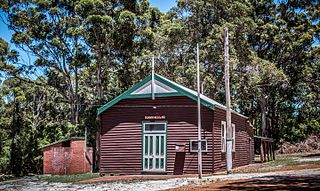
Jarrahdale is a small historic town located 45 km south-east of Perth, Western Australia in the Darling Range. The name is derived from its situation in a jarrah forest. Established in the late 1800s as the state's first major timber milling operation, it played a key role in the development of Western Australia through the exportation of jarrah around the world. At the 2016 census, Jarrahdale had a population of 1,192. Since 2001, the historic precinct has been managed by the state's National Trust organisation alongside private residential and tourism-oriented developments.
Maurice Coleman Davies was an Australian timber merchant and pastoralist. Born in London, he emigrated to Tasmania with his family as a child, and later moved to Blackwood in the Victorian goldfields, then to Melbourne and Adelaide. He then relocated to Western Australia, where he created the M. C. Davies Company, later the M. C. Davies Karri and Jarrah Timber Company, a timber empire that employed hundreds of men, laid over a hundred kilometres of private railway, including the Flinders Bay branch railway, and even built its own private ports for exporting of timber. He also formed the Kimberley Pastoral Company and was its managing director.
In early 1961, a series of bushfires burned in the south-west region of Western Australia. The devastating fires burned large areas of forest in and around Dwellingup from 20 to 24 January, at Pemberton and in the Shannon River region between 11 and 15 February, and in the Augusta-Margaret River area in early March. There were also major fires which burned in the Darling Scarp around Kalamunda. The towns of Dwellingup and Karridale were largely destroyed by the fires, as were a number of smaller railway and mill settlements. There was no loss of human life.
Northcliffe is a town located in the lower South West region of Western Australia, about 28 kilometres (17 mi) south of the town of Pemberton. It is part of the Shire of Manjimup. At the 2006 census, Northcliffe had a population of 412. Currently, Northcliffe serves a population of around 770 people within the town and surrounding areas. Approximately 31% of the population have post-secondary qualifications.

Nanga Brook is a former town located in the Peel region of Western Australia in the Lane Poole Reserve between Dwellingup and Waroona.
Gleneagle or Glen Eagle is a locality in Western Australia. The locality is south east of the state capital, Perth, close to Jarrahdale on the Albany Highway.

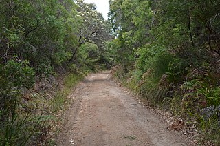
The network of railway lines in Western Australia associated with the timber and firewood industries is as old as the mainline railway system of the former Western Australian Government Railways system.

The Yarloop Workshops was a railway and timber mill machinery workshop, situated in the town of Yarloop, Western Australia.
Kudardup is a locality in the South West region of Western Australia. The locality is in the Shire of Augusta-Margaret River and on the Bussell Highway, 312 kilometres (194 mi) south of the state capital, Perth.
Millars' Karri and Jarrah Company (1902) Limited, commonly known as Millars, was a Western Australian focused timber and timber railway company.

Boranup is a locality in the Shire of Augusta-Margaret River in the South West region of Western Australia. It is the site of a large coastal dune blow out known as the "Boranup sand patch" as part of the Boranup beach, and the site of a former M. C. Davies timber company mill. The sand patch area and sand blows affected the alignment of the Busselton to Flinders Bay railway.

The Forests Department was a department of the Government of Western Australia created in 1919 under Conservator of Forests Charles Lane Poole, that was responsible for implementing the State's Forests Act (1918–1976) legislation and regulations.
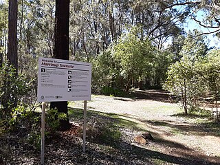
Marrinup is a rural locality and former town in the Peel region of Western Australia between Dwellingup and Pinjarra. Its local government area is the Shire of Murray. The town was destroyed in the 1961 bushfires and the townsite is now used as a campground. The ruins of the townsite are heritage listed. Little remains of the town other than an old bridge over Marrinup Creek and some wooden railway sleepers.


