
The Shire of Augusta Margaret River is a local government area in the south-west corner of the South West region of Western Australia, approximately 270 kilometres (168 mi) south of Perth. The shire covers an area of 2,243 square kilometres (866 sq mi) and had a population of over 14,000 at the 2016 Census, about half of whom live in the towns of Margaret River and Augusta.

The Shire of Bridgetown–Greenbushes is a local government area in the South West region of Western Australia, about 80 kilometres (50 mi) southeast of Bunbury and about 260 kilometres (162 mi) south of the state capital, Perth. The Shire covers an area of 1,340 square kilometres (517 sq mi), and its seat of government is the town of Bridgetown.

The Shire of Upper Gascoyne is a local government area in the Gascoyne region of Western Australia, inland from Carnarvon and about 1,000 kilometres (620 mi) north of the state capital, Perth. The Shire has an area of 57,939 square kilometres (22,370 sq mi), much of which is uninhabited land or sparsely vegetated sheep station country, and its seat of government is the small town of Gascoyne Junction. It has a population of 170, 56% of whom identify as Aboriginal.

The Shire of Boyup Brook is a local government area located in the South West region of Western Australia, about 270 kilometres (168 mi) southeast of Perth, the state capital. The Shire covers an area of 2,829 square kilometres (1,092 sq mi) and its seat of government is the town of Boyup Brook.

The Shire of Collie is a local government area in the South West region of Western Australia, about 60 kilometres (37 mi) east of Bunbury and about 200 kilometres (124 mi) south of the state capital, Perth. The Shire covers an area of 1,711 square kilometres (661 sq mi), and its seat of government is the town of Collie.
The Shire of Dardanup is a local government area in the South West region of Western Australia, immediately to the east and southeast of the City of Bunbury and about 180 kilometres (112 mi) south of the state capital, Perth. The Shire covers an area of 526.6 square kilometres (203.3 sq mi), and its seat of government is in Eaton in Bunbury's eastern suburbs.

The Shire of Woodanilling is a local government area in the Great Southern region of Western Australia, about 30 kilometres (19 mi) south of Wagin and about 260 kilometres (162 mi) south-southeast of the state capital, Perth. The Shire covers an area of 1,129 square kilometres (436 sq mi), and its seat of government is the town of Woodanilling.
Benjinup is a rural locality of the Shire of Boyup Brook in the South West region of Western Australia.
Chowerup is a rural locality of the Shire of Boyup Brook in the South West region of Western Australia.
Scotts Brook is a rural locality of the Shire of Boyup Brook in the South West region of Western Australia.
Yourdamung Lake is a predominantly forested rural locality of the Shire of Collie in the South West region of Western Australia. Except for the Collie to Williams Road in the very south of Yourdamung Lake, no major roads lead through the locality.

Harris River is a predominantly forested rural locality of the Shire of Collie in the South West region of Western Australia.
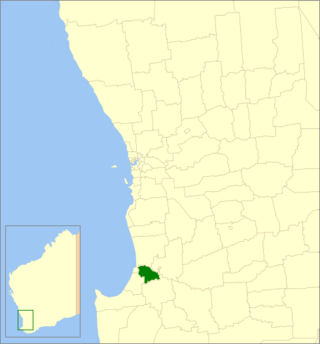
Palmer is a rural locality of the Shire of Collie in the South West region of Western Australia. The southern part of the locality, south of the Collie–Williams Road, is dominated by coal mining and the Collie Power Station, while the remainder is split between state forest and farm land.
Preston Settlement is a rural locality of the Shire of Collie in the South West region of Western Australia.
Dardanup West is a rural locality of the Shire of Dardanup in the South West region of Western Australia.

Ferguson is a rural locality of the Shire of Dardanup in the South West region of Western Australia. The locality of Ferguson and the Ferguson Valley are marketed as a tourist destination.
Henty is a rural locality of the Shire of Dardanup in the South West region of Western Australia.
Paradise is a rural locality of the Shire of Dardanup in the South West region of Western Australia.
Picton East is a predominatly rural locality of the Shire of Dardanup in the South West region of Western Australia. apart from farm land, the suburb also includes commercial areas in its central section. Its northern boundary is formed by the Forrest Highway while the South Western Highway and the South Western Railway also runs through it.
Wellington Forest is a forested locality of the Shire of Dardanup in the South West region of Western Australia. Wellington National Park is predominantly located within the locality.
