
Margaret River is a town in the South West of Western Australia, located in the valley of the eponymous Margaret River, 277 kilometres (172 mi) south of Perth, the state capital. Its Local Government Area is the Shire of Augusta-Margaret River.

The Noongar are Aboriginal Australian peoples who live in the south-west corner of Western Australia, from Geraldton on the west coast to Esperance on the south coast. There are 14 different Noongar groups: Amangu, Ballardong, Yued, Kaneang, Koreng, Mineng, Njakinjaki, Njunga, Pibelmen, Pindjarup, Wadandi, Whadjuk, Wiilman and Wudjari. The Noongar people refer to their land as Noongar boodja.

Busselton is a city in the South West region of the state of Western Australia approximately 220 km (140 mi) south-west of Perth. Busselton has a long history as a popular holiday destination for Western Australians; however, the closure of the Busselton Port in 1972 and the contemporaneous establishment of the nearby Margaret River wine region have seen tourism become the dominant source of investment and development, supplemented by services and retail. The city is best known for the Busselton Jetty, the longest wooden jetty in the Southern Hemisphere.

The Shire of Augusta Margaret River is a local government area in the south-west corner of the South West region of Western Australia, approximately 270 kilometres (168 mi) south of Perth. The shire covers an area of 2,243 square kilometres (866 sq mi) and had a population of over 14,000 at the 2016 Census, about half of whom live in the towns of Margaret River and Augusta.

Capel is a town in the South West region of Western Australia, located 212 kilometres (132 mi) south of Perth and midway between Bunbury and Busselton. The town is located on the Capel River and is approximately 19 metres (62 ft) above sea level.

Augusta is a town on the south-west coast of Western Australia, where the Blackwood River emerges into Flinders Bay. It is the nearest town to Cape Leeuwin, on the furthest southwest corner of the Australian continent. In the 2001 census it had a population of 1,091; by 2016 the population of the town was 1,109.
Dunsborough is a coastal town in the South West of Western Australia, 254 kilometres (158 mi) south of Perth, on the shores of Geographe Bay.
The townsite of Wonnerup is located 219 kilometres (136 mi) south of Perth and 10 kilometres (6 mi) east of Busselton. It was gazetted a townsite in 1856, deriving its name from the nearby Wonnerup Inlet.
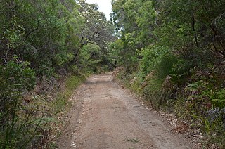
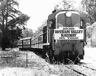
The Flinders Bay Branch Railway, also known as the Boyanup to Flinders Bay Section ran between Boyanup and Flinders Bay, in South Western Western Australia. The section from Flinders Bay to Busselton has now been converted into a rail trail for bushwalkers and cyclists, called the Wadandi Trail.
Nannup is a town in the South West region of Western Australia, approximately 280 kilometres (174 mi) south of Perth on the Blackwood River at the crossroads of Vasse Highway and Brockman Highway; the highways link Nannup to most of the lower South West's regional centres. At the 2011 census, Nannup had a population of 587.
Samuel Yebble Isaacs was an Aboriginal Australian stockman and farmer from the South West of Western Australia, who was best known for his role in the rescue of the SS Georgette in 1876, together with Grace Bussell.

The City of Busselton is a local government area in the South West region of Western Australia, approximately 230 km (140 mi) south of Perth, the state capital. The city covers an area of 1,455 km2 (562 sq mi) and had a population of 40,640 as at the 2021 Census. It contains two large towns, Busselton and Dunsborough, and a number of smaller towns. The city office is located on Southern Drive, Busselton.

Vasse is a suburb of the city of Busselton in the South West region of Western Australia, 10 kilometres (6 mi) west of Busselton and 240 kilometres (149 mi) southwest of Perth. Its local government area is the City of Busselton. At the 2016 census, Vasse had a population of 2,479.
Cowaramup is a town in the South West of Western Australia, 12 kilometres north of Margaret River in the Shire of Augusta-Margaret River.

Yallingup is a town in the South West region of Western Australia, 256 kilometres (159 mi) south of Perth. Yallingup is a popular tourist destination because of its beaches and limestone caves, and proximity to Leeuwin-Naturaliste National Park.
Kevin John Cullen, AM was an Australian medical doctor, researcher, and winemaker, active in Western Australia's South West. He is best known for his role in founding the Busselton Health Study and Cullen Wines.
Yoongarillup is a locality in Western Australia's South West region in the local government area of the City of Busselton. At the 2021 census, the area had a population of 79.
Metricup is a locality in the South West region of Western Australia near the town of Cowaramup on the Bussell Highway. It is in the Margaret River wine region and its local government area is the City of Busselton. At the 2021 census, it had a population of 263.
Yalyalup is a suburb of the Western Australian city of Busselton. At the 2021 census, it had a population of 2,950.
Chapman Hill is a locality in the South West region of Western Australia in the local government area of the City of Busselton. At the 2021 census, the area had a population of 109.


