
The Town of Cambridge is a local government area in the inner western suburbs of the Western Australian capital city of Perth, about 5 kilometres (3 mi) west of Perth's central business district and extending to the Indian Ocean at City Beach. The Town covers an area of 22.0 square kilometres (8.5 sq mi) and had a population of almost 29,000 as of the 2021 Census. It was originally part of the City of Perth before the restructuring by the Western Australian State Government in 1994.

The City of Kwinana is a local government area of Western Australia. It covers an area of approximately 118 square kilometres in metropolitan Perth, and lies about 38 km south of the Perth central business district, via the Kwinana Freeway. Kwinana maintains 287 km of roads and had a population of almost 39,000 as at the 2016 Census.

Cranbrook is a small town in the Shire of Cranbrook in the Great Southern region of Western Australia between Katanning, Kojonup and Mount Barker, situated 320 km south of Perth. It is billed as "The Gateway to the Stirlings", referring to the nearby Stirling Range National Park. At the 2006 census, Cranbrook had a population of 280.
Elleker is a small town and locality of the City of Albany in the Great Southern region of Western Australia. It is located approximately about 16 kilometres (10 mi) west of the regional city of Albany. It is situated along the Lower Denmark Road; the main tourist route from Albany to Denmark.

Tumby Bay is a coastal town situated on the Spencer Gulf, on the eastern coast of Eyre Peninsula in South Australia, 45 kilometres (28 mi) north of Port Lincoln. The town of Tumby Bay is the major population centre of the District Council of Tumby Bay, and the centre of an agricultural district farming cereal crops and sheep, as well as having established fishing and tourism industries.
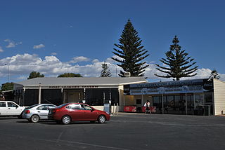
Port Hughes is a town and locality in the Australian state of South Australia located on northern Yorke Peninsula about 135 kilometres (84 mi) north-west of the state capital of Adelaide. It is considered part of the Moonta urban area by the Australian Bureau of Statistics. At the 2016 census, Port Hughes had a population of 571.
Frankland River is a small town and locality in the Shire of Cranbrook, Great Southern region of Western Australia. The town is situated approximately 332.7 km (206.7 mi) from the state's capital, Perth, approximately 120 km (75 mi) north west of Albany, 83 km (52 mi) southwest of Kojonup, 19 km (12 mi) north of Rocky Gully and 90 km (56 mi) east of Manjimup. Frankland derives its name from its location 6 km east of the Frankland River. At the 2006 census, Frankland had a population of 380.

The City of Busselton is a local government area in the South West region of Western Australia, approximately 230 km (140 mi) south of Perth, the state capital. The city covers an area of 1,455 km2 (562 sq mi) and had a population of 40,640 as at the 2021 Census. It contains two large towns, Busselton and Dunsborough, and a number of smaller towns. The city office is located on Southern Drive, Busselton.
Nyabing is a small town and locality in the Great Southern region of Western Australia. The name is of Aboriginal origin and is thought to derive from the Aboriginal word "ne-yameng", which is the name of an everlasting flower Rhodanthe manglesii. It is one of two localities in the Shire of Kent, the other being Pingrup, covering the east of the shire.

Kalgan is a small town and locality of the City of Albany in the Great Southern region of Western Australia. The South Coast Highway runs through the locality from west to east. The western part of Gull Rock National Park is located within Kalgan. The town is situated on the banks of the Kalgan River and was first known as Kalganup which means "place of first camp" or "place of many waters". Indigenous Australians used the area as a meeting place up to 19,000 years ago. The name was first recorded in 1831, when explorer Alexander Collie charted the area.
Redmond is a town and locality of the City of Albany in the Great Southern region of Western Australia. It is located 399 km south-south-east of Perth and the closest populated town is Albany.
Needilup is a town and locality in the Shire of Jerramungup, Great Southern region of Western Australia. Needilup is situated between Ongerup and Jerramungup along the Gnowangerup-Jerramungup Road.
Muradup is a small town and locality in the Shire of Kojonup, Great Southern region of Western Australia. Muradup is located between Kojonup and Boyup Brook, and is situated along the Balgarup River.
Bornholm is a locality of the City of Albany in the Great Southern region of Western Australia. The coastal region of the locality, facing the Southern Ocean, is covered by the West Cape Howe National Park. It is located between Albany and Denmark on the Lower Denmark Road.
Little Grove is a suburb of the City of Albany in the Great Southern region of Western Australia. The suburb is bounded by the Princess Royal Harbour to the north and west.
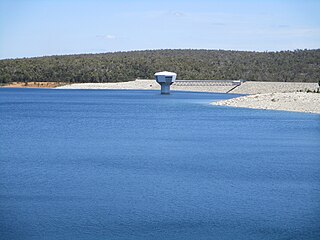
Whittaker is a rural locality of the Shire of Murray in the Peel Region of Western Australia. North Dandalup Dam and its reservoir are located within the locality in its north-western corner.
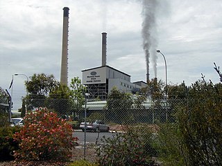
Muja is a rural town and locality of the Shire of Collie in the South West region of Western Australia. The western part of the locality is dominated by coal mining and the coal-fired Muja Power Station while the eastern part is rural and forested.

East Nannup is a rural locality of the Shire of Nannup in the South West region of Western Australia. The Brockman Highway forms the northern boundary of the locality along its entire length. The western part of East Nannup is a mixture of farmland and forest while the eastern part is completely forested.
Quinninup is a rural locality of the Shire of Manjimup in the South West region of Western Australia. The South Western Highway forms much of its eastern border, as does the Warren River to the north. The eastern parts of Greater Dordagup National Park are located within Quinninup.
Marbelup is a townsite and locality of the City of Albany in the Great Southern region of Western Australia. The South Coast Highway runs through the locality west to east while the Great Southern Railway passes through it from north to south. The Marbelup Nature Reserve surrounds the remaining gazetted townsite, just 4,052 square metres (43,620 sq ft) in size, on three sides but no town actually exists at location.

