
Margaret River is a town in the South West of Western Australia, located in the valley of the eponymous Margaret River, 277 kilometres (172 mi) south of Perth, the state capital. Its Local Government Area is the Shire of Augusta-Margaret River.

Busselton is a city in the South West region of the state of Western Australia approximately 220 km (140 mi) south-west of Perth. Busselton has a long history as a popular holiday destination for Western Australians; however, the closure of the Busselton Port in 1972 and the contemporaneous establishment of the nearby Margaret River wine region have seen tourism become the dominant source of investment and development, supplemented by services and retail. The city is best known for the Busselton Jetty, the longest wooden jetty in the Southern Hemisphere.

Narrikup is a small town and locality in the Shire of Plantagenet, Great Southern region of Western Australia. Narrikup is located between Albany and Mount Barker. At the 2006 census, Narrikup had a population of 515.

Augusta is a town on the south-west coast of Western Australia, where the Blackwood River flows into Flinders Bay. It is the nearest town to Cape Leeuwin, on the furthest southwest corner of the Australian continent. In the 2001 census it had a population of 1,091; by 2016 the population of the town was 1,109.
Dunsborough is a coastal town in the South West of Western Australia, 254 kilometres (158 mi) south of Perth, on the shores of Geographe Bay.
The townsite of Wonnerup is located 219 kilometres (136 mi) south of Perth and 10 kilometres (6 mi) east of Busselton. It was gazetted a townsite in 1856, deriving its name from the nearby Wonnerup Inlet.

Wubin is a small town located in the northern Wheatbelt region of Western Australia, 272 kilometres (169 mi) north-northeast of Perth and 21 kilometres (13 mi) north of Dalwallinu.

Three Springs is a town located 313 kilometres (194 mi) north of Perth, Western Australia on the Midlands Road, which until the opening of the Brand Highway in 1975 was the main road route from Perth to the state's north. The town is the seat of the Shire of Three Springs. Its economy is based on agriculture and mining.
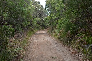
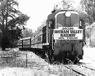
The Flinders Bay branch railway, also known as the Boyanup to Flinders Bay section ran between Boyanup and Flinders Bay, in South Western Western Australia. The section from Flinders Bay to Busselton has now been converted into a rail trail for bushwalkers and cyclists, called the Wadandi Trail.
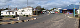
Nannup is a town in the South West region of Western Australia, approximately 280 kilometres (174 mi) south of Perth on the Blackwood River at the crossroads of Vasse Highway and Brockman Highway; the highways link Nannup to most of the lower South West's regional centres. At the 2011 census, Nannup had a population of 587.

The City of Busselton is a local government area in the South West region of Western Australia, approximately 230 km (140 mi) south of Perth, the state capital. The city covers an area of 1,455 km2 (562 sq mi) and had a population of 40,640 as at the 2021 Census. It contains two large towns, Busselton and Dunsborough, and a number of smaller towns. The city office is located on Southern Drive, Busselton.
Karridale is a small township in the south-west of Western Australia. It is located just north of Augusta and south of Margaret River between Caves Road and Bussell Highway. A newer township was built a short distance north east of the original Old Karridale following fires that destroyed the town in 1961. At the 2006 census, Karridale had a population of 285.

Vasse is a suburb of the city of Busselton in the South West region of Western Australia, 10 kilometres (6 mi) west of Busselton and 240 kilometres (149 mi) southwest of Perth. Its local government area is the City of Busselton. At the 2021 census, Vasse had a population of 2,853.

Nungarin is a town located in the north east of the Wheatbelt region of Western Australia, approximately 278 kilometres (173 mi) east of Perth and 39 kilometres (24 mi) north of Merredin. It is the main town in the Shire of Nungarin. At the 2006 census, Nungarin had a population of 142.
Cowaramup is a town in the South West of Western Australia, 12 kilometres north of Margaret River in the Shire of Augusta-Margaret River.
Ajana is a townsite within the Shire of Northampton in Western Australia. It is located at the junction of Ajana-Kalbarri Road and Ajana Back Road, 53 kilometres (33 mi) by road north of Northampton, 61 kilometres (38 mi) by road southwest of Kalbarri, and 531 kilometres (330 mi) west-northwest of Perth in the Mid West region.

Clackline is a locality in the Wheatbelt region of Western Australia, about 80 kilometres (50 mi) east-north-east of Perth.

Witchcliffe is a small town in the South West region of Western Australia, located a few kilometres south of Margaret River on the Bussell Highway. The name originates from a cave in the area, Witchcliffe cave, that was recorded by a surveyor in 1900. It is believed the name was given by the Bussell family whose property, Wallcliffe, was established in the area in the 1850s.
Kudardup is a locality in the South West region of Western Australia. The locality is in the Shire of Augusta-Margaret River and on the Bussell Highway, 312 kilometres (194 mi) south of the state capital, Perth.

Ludlow is a locality in the South West region of Western Australia near the Tuart Forest National Park. It is in the local government areas of the City of Busselton and the Shire of Capel. At the 2021 census, the area had a population of 132.

