
Collie is a town in the South West region of Western Australia, 213 kilometres (132 mi) south of the state capital, Perth, and 59 kilometres (37 mi) inland from the regional city and port of Bunbury. It is near the junction of the Collie and Harris Rivers, in the middle of dense jarrah forest and the only coalfields in Western Australia. At the 2021 census, Collie had a population of 7,599.
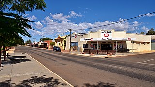
Morawa is a town in the Mid West region of Western Australia. It is located within the Shire of Morawa, approximately 370 kilometres (230 mi) north of the state capital Perth, on the railway line between Wongan Hills and Mullewa.

The Belmont railway line is an abandoned coal haulage and passenger rail line from Adamstown, New South Wales to Belmont, New South Wales. This was a private railway, being the property of the New Redhead Estate and Coal Company and was generally known as the Belmont Branch. The line closed in December 1991. It has since been converted into a cycleway or rail trail - The Fernleigh Track.

Wubin is located in the northern Wheatbelt region of Western Australia, 272 kilometres (169 mi) north-northeast of Perth and 21 kilometres (13 mi) north of Dalwallinu.

Three Springs is a town located 313 kilometres (194 mi) north of Perth, Western Australia on the Midlands Road, which until the opening of the Brand Highway in 1975 was the main road route from Perth to the state's north. The town is the seat of the Shire of Three Springs. Its economy is based on agriculture and mining.

Worsley is a town in Western Australia located in the South West region near the town of Collie. The town is within the Shire of Collie.

Shotts is a town in North Lanarkshire, Scotland. It is located almost halfway between Glasgow and Edinburgh. The village has a population of about 8,840. A local story has Shotts being named after the legendary giant highwayman Bertram de Shotts, though toponymists give the Anglo-Saxon scēots as the real source of the name. Shotts is the home of the 2015 world champion pipe band, Shotts and Dykehead Caledonia Pipe Band.

Collie-Preston is a Legislative Assembly electorate in the state of Western Australia. While the seat was known as Collie for just over a century of its existence as an electorate, the seat was known as South West Mining from 1901 to 1904, and Collie-Wellington from 2005 to 2008. It is named for the South West coal mining town of Collie. While historically a very safe seat for the Labor Party, redistributions in 1988 and 2007 due to increases in the quota for country seats which had historically been malapportioned resulted in the seat incorporating surrounding rural shires which were hostile to Labor and thereby becoming more marginal.
Roelands is a town in the South West region of Western Australia on the South Western Highway, between Brunswick Junction and Bunbury. At the 2011 census, Roelands had a population of 620.
Collie Power Station is a power station in Collie, Western Australia. It is coal powered with one steam turbine that generates a total capacity of 300 megawatts of electricity. The coal is mined locally from the Collie Sub-basin and is transported to the power plant by overland conveyor. On 14 June 2022 the state government announced that Synergy would close Collie Power Station by 2027.

Tara is a rural town and locality in the Western Downs Region, Queensland, Australia. In the 2021 census, the locality of Tara had a population of 1,980 people.

The Shire of Collie is a local government area in the South West region of Western Australia, about 60 kilometres (37 mi) east of Bunbury and about 200 kilometres (124 mi) south of the state capital, Perth. The Shire covers an area of 1,711 square kilometres (661 sq mi), and its seat of government is the town of Collie.

Thomas Henry Jones OAM was an Australian politician and trade union leader. He served the Labor Party as member for Collie from 1968 until his retirement in 1989.
Allanson is a town on the banks of the Collie River in the South West region of Western Australia, 8 kilometres (5.0 mi) by road west-northwest of Collie. The Coalfields Highway passes through the town.

Burekup is a small town located on the South Western Highway in the South West region of Western Australia.
Eradu is a small town in Western Australia located in the Mid West region of Western Australia 34 kilometres (21 mi) east of Geraldton on the Geraldton–Mount Magnet Road.

Coomberdale is a small town located along the Midlands Road between Moora and Watheroo in the Wheatbelt region of Western Australia. It had 56 residents in the 2021 census.
The Collie Mail was established at Collie, Western Australia in 1908 by Mr H.E. Reading, who had previously established The Southern Times in Bunbury. The paper was published bi-weekly to share the news and information of the new coal mining town of Collie.
Torbane was a privately-owned village lying within the area now known as Capertee, in the Local Government Area of the City of Lithgow, within the Central West region of New South Wales, Australia. There was also another village, Airly, nearby. Both villages were associated with the mining of oil shale. The mine associated with Torbane was known as the New Hartley Mine. and that associated with Airly was known as the Genowlan Mine. There were retorts that produced crude shale oil at Torbane. Both Torbane and Airly are now ghost towns.
Western Australia, like other Australian states and high-income countries, is a heavy energy user by global standards.

