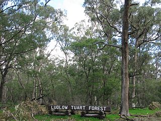
Tuart Forest National Park is a national park in the South West region of Western Australia, 183 kilometres (114 mi) south of Perth. It contains the largest remaining section of pure tuart forest in the world. Traditionally the state forest associated with this stand of trees has been known as the Ludlow State Forest, named for Frederick Ludlow.

Busselton is a city in the South West region of the state of Western Australia approximately 220 km (140 mi) south-west of Perth. Busselton has a long history as a popular holiday destination for Western Australians; however, the closure of the Busselton Port in 1972 and the contemporaneous establishment of the nearby Margaret River wine region have seen tourism become the dominant source of investment and development, supplemented by services and retail. The city is best known for the Busselton Jetty, the longest wooden jetty in the Southern Hemisphere.

The Strzelecki Ranges is a set of low mountain ridges located in the West Gippsland and South Gippsland regions of the Australian state of Victoria.
Frederick Ludlow was an early colonial settler in Western Australia. He is credited with the discovery of the Capel River.

Pemberton is a town in the South West region of Western Australia, named after original settler Pemberton Walcott.
The Flinders Bay Branch Railway, also known as the Boyanup to Flinders Bay Section ran between Boyanup and Flinders Bay, in South Western Western Australia. The section from Flinders Bay to Busselton has now been converted into a rail trail for bushwalkers and cyclists, called the Wadandi Trail.

Kirup, originally named Upper Capel, then Kirupp, is situated between Donnybrook and Balingup on the South Western Highway, 228 kilometres (142 mi) south of Perth, Western Australia in the upper reaches of the Capel River valley.

Jarrahdale is a small historic town located 45 km south-east of Perth, Western Australia in the Darling Range. The name is derived from its situation in a jarrah forest. Established in the late 1800s as the state's first major timber milling operation, it played a key role in the development of Western Australia through the exportation of jarrah around the world. At the 2016 census, Jarrahdale had a population of 1,192. Since 2001, the historic precinct has been managed by the state's National Trust organisation alongside private residential and tourism-oriented developments.

Bussell Highway is a generally north–south highway in the South West region of Western Australia. The highway links the city of Bunbury with the town of Augusta and is approximately 140 kilometres (87 mi) in length. The highway is signed State Route 10, except in Busselton where the construction of the Busselton Bypass in 2000 resulted in this stretch being changed to Alternate State Route 10 with the Bypass signed State Route 10.

Eucalyptus gomphocephala, known as tuart, is a species of tree, one of the six forest giants of Southwest Australia. Tuart forest was common on the Swan coastal plain, until the valuable trees were felled for export and displaced by the urban development around Perth, Western Australia. The wood is dense, hard, water resistant and resists splintering, and found many uses when it was available. Remnants of tuart forest occur in state reserves and parks, the tree has occasionally been introduced to other regions of Australia and overseas. Remaining trees are vulnerable to phytophthora dieback, an often fatal disorder, including a previously unknown species discovered during analysis of dead specimens.

The Dryandra Woodland National Park is a national park in Western Australia within the shires of Cuballing, Williams and Wandering, about 164 kilometres south-east of Perth and 22 kilometres north-west of the town of Narrogin. It is a complex of 17 distinct blocks managed by the Western Australian Department of Parks and Wildlife and spread over approximately 50 kilometres separated by areas of agricultural land. The area is considered to be one of the state's major conservation areas, and although it is far from pristine due to its history of logging operations, a number of species of threatened fauna are rebuilding populations through the removal of introduced predators such as foxes and feral cats.
Charles Edward Lane Poole was an English Australian forester who introduced systematic, science-based forestry practices to various parts of the Commonwealth, most notably Australia.

The Shire of Capel is a local government area in the South West region of Western Australia, taking in the land between the cities of Bunbury and Busselton about 200 kilometres (124 mi) south of the state capital, Perth. The Shire covers an area of 557.6 square kilometres (215.3 sq mi), and its seat of government is the town of Capel.

Dalyellup,, is an outer northern suburb of the Shire of Capel local government area. The suburb was established in 1999 when the Department of Housing and Works entered into a joint venture with Satterley Property Group to develop Dalyellup Beach Estate, a master-planned community which was expected to yield 3,000 lots by its completion in 2012.

Tuart forest is an open forest in which the dominant overstorey tree is Eucalyptus gomphocephala (tuart). This form of vegetation occurs only in the Southwest Botanical Province of Western Australia. Tuart being predominantly a coastal tree, tuart forest occurs only in a narrow belt along the coast.
Quindalup is a small town in the South West region of Western Australia. It is situated along Caves Road between Busselton and Dunsborough on Geographe Bay. At the 2021 census, Quindalup had a population of 1,488.
Henry Yelverton was an Australian sawmiller and timber merchant.

Jimna Single Men's Barracks is a heritage-listed workers' housing at 4 Tip Road, Jimna, Somerset Region, Queensland, Australia. It was built in 1930s. It was added to the Queensland Heritage Register on 27 November 2008.

Elgin Vale Sawmill is a heritage-listed sawmill at Manumbar Road, Elgin Vale, Gympie Region, Queensland, Australia. It was built in 1944 for T H Spencer by Wilson Hart Limited. It was added to the Queensland Heritage Register on 17 September 2010.
The Wooleybah Sawmill and Settlement is a heritage-listed former small settlement and sawmill at Old Wooleybah Road, Kenebri, Warrumbungle Shire, New South Wales, Australia. It was built from 1935 by the Underwood family. It is also known as Wooleybah Dead Man's Waterhole. The property is owned by Forestry Commission of NSW, an agency of the Government of New South Wales. It was added to the New South Wales State Heritage Register on 17 December 2010.