The Department of Parks and Wildlife (DPaW) was the department of the Government of Western Australia responsible for managing lands described in the Conservation and Land Management Act 1984 and implementing the state's conservation and environment legislation and regulations. The minister responsible for the department was the Minister for the Environment.
DPaW focused on managing multiple use state forests, national parks, marine parks and reserves. DER focused on environmental regulation, approvals and appeals processes, and pollution prevention.
The Department of Parks and Wildlife had management responsibilities in:[3]
nature reserves (10,267,826 ha)
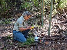
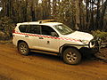
100 national parks (6,267,602 ha) Western Australia Parks and Wildlife National Park Ranger assessing public frequentation on a Metro Count Vehicle Classifier System, Warren National Park, Donnelly District, December 2014.
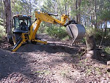
State forests (1,309,755 ha) Western Australia Parks and Wildlife Conservation Employee changing a culvert pipe at Dombakup Block, Warren State Forest in May 2015. and
other lands and waters throughout the state
At 30 June 2017, the total area under Parks and Wildlife's care was 31,480,868 ha. The land area managed by the department was about 10.6 per cent of the land area of Western Australia.
The lands and waters managed by the department received in 2014-15[4] 18.6 million visits a year, with visitor satisfaction at a high level of 89%. The average level of visitor satisfaction with their visit on Parks & Wildlife lands and waters was of 91.4% in 2015-16.[5] Western Australian national parks and reserves received 20 million visits in a single year for the first time in 2016–17 and a visitor satisfaction level of 92.5 per cent. Each year Parks and Wildlife aimed for a satisfaction rating above 85 per cent, a figure it had achieved for more than 10 consecutive years.
10,910 people were registered volunteers with the department in 2014-15 that helped in a range of projects across the State with 610,000 hours contributed. During 2015-16, 5,189 active volunteers of the total 13,737 registered individuals contributed 638,747 voluntary hours to more than 200 Parks and Wildlife environmental and recreational programs.[6] In 2016-17, Parks and Wildlife's volunteers have contributed to a record number of hours to help conserve and manage WA’s natural places, with 5,410 volunteers contributing 723,508 hours.[7]
Parks and Wildlife was responsible for the wildlife conservation project Western Shield,[8] a pest animal and weed control program that included 4 million hectares of conservation reserves and State forests baited for feral animal control, as well as weed control on more than 89 million hectares of unallocated Crown land and unmanaged reserves.[9]
There are a number of internationally recognised biodiversity hotspots within Western Australia and in particular in the south west of the state.[10]
An important duty of the Department (with the help of the Forest Products Commission crews) was to be responsible for bushfire prevention and suppression on its lands as well as fire prevention in unallocated Crown land and unmanaged reserves. This included conducting controlled burns to reduced fuel load, and research into the behaviour and effects of bushfires.[13]
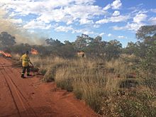
WA Parks and Wildlife fire crew lighting a prescribed burn at Octopus Bore track buffer, Lorna Glen former pastoral lease, now joint managed with traditional owners, May 2015.Western Australia Parks and Wildlife Fire Fighters mopping up the fireline with the help of a Gang Truck fire appliance (GT3 - Donnelly 36) after a machinery constructed track was opened on a bushfire on Topanup Block, Tone State Forest, March 2015.
More than 247,360 hectares were prescribed burnt in the three forest regions during the 2016-17 financial year,[14] in addition to the significant burns that have been undertaken by staff in the South Coast, Goldfields, Wheatbelt, Mid West, Pilbara and Kimberley regions up to 2,988,394 hectares.
Some of the most severe West Australian bushfires that the department had to suppress, in chronological order, include:
Swan River Trust: 1989 (Swan and Canning Rivers Management Act 2006) - 1 July 2015[19]
Vehicles
The department maintained and coordinated a range of specialist equipment and emergency response vehicles. This included pumpers and tankers and other equipment relating to operations involving search and rescue and firefighting.
Gang truck fire appliance Izusu 550 (GT2 - Donnelly 37) at Dwellingup in October 2014.
Heavy duty fire appliance Izusu 550 (HD122 - Blackwood 44) at Pemberton depot in March 2015.
High lift fire appliance Izusu 750 (HL3 - Perth Hills 49) at 100 Years Old Forest prescribed burning, Donnelly State Forest, January 2017.
Light patrol (fast attack) Toyota Hilux 3.0 D4D SR at Dwellingup depot in October 2014.
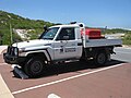
4WD vehicle (used by a sector commander) Toyota Land Cruiser, Perth Hills, October 2014.
Pantech communication vehicle at Pemberton depot during DON019 O'Sullivan bushfire in February 2015.
National park ranger light patrol in Toyota Landcruiser V8D4D Turbo Work Mate at Nambung National Park in October 2013.
Komatsu WA320 front end loader (plant P7) in Perth Hills for a prescribed fire in October 2014.
Caterpillar D6 dozer (plant P2) at Mount Solus group bushfire in November 2015.
Deere 670D grader (plant P28) at Dwellingup depot in October 2014.
Fire bomber Airtractor 802 being reloaded at Orleans Farm (Tagon) airstrip, close to Cape Arid National Park, Esperance, November 2014.
American Scout Champion Aircraft 8GCBC (spotter 642) at Bunbury airport, August 2015.
Sikorsky S-64 Aircrane Erickson Inc. Helicopter during O'Sullivan bushfire, Manjimup airport, February 2015.
Sikorsky S-64 Aircrane Erickson Inc. Helicopter during Mount Solus group bushfire, Perth Hills, November 2015.
Bell 412EP Helitaks water bomber during Mount Solus group bushfire, Perth Hills, November 2015.
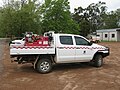
Izusu 300 4WD tender at Dwellingup depot, October 2014.
Uniforms and equipment
The Department of Parks and Wildlife had three types of uniforms:[20]
a standard khaki and bottle green uniform with appropriate badging was supplied to and worn by staff whose duties included the monitoring of legislative compliance (National Park and Marine Rangers, Conservation and Land Management Officers, Forest Officers, Wildlife Officers and Authorised CALM Officers under Bush Fire Act),
a work wear (khaki and bottle green only with generic badge) for those that worked in the field and personal protective equipment or clothing (TecaSafe gold overshirt, TecaSafe dark green trousers and vest, Kevlar helmet with goggles, gloves, belt and fire boots) for staff who were involved in fire management activities,
a corporate apparel worn by employees who were in regular contact with the public or members of other departments (sand, grey or white shirt, black trousers).
Western Australian Department of Parks and Wildlife shoulder's badges, 2013.[21]
Western Australian Department of Parks and Wildlife shoulder's badges, 2015.
Department of Parks and Wildlife's logo positioned above the left pocket on all corporate apparels, 2013.
Conservation and Land Management Officer under CALM Act 1984 shoulder badge for uniform shirt, 2013.
National Park Ranger under CALM Act 1984 shoulder badge for uniform shirt, 2013.
Marine Ranger and Officer shoulder badge for uniform shirt, 2013.
Wildlife Officer under Wildlife Conservation Act 1950 shoulder badge for uniform shirt, 2016.
Conservation and Land Management Officer under CALM Act 1984 (with Bushfire Act 1954 powers) shoulder badge for uniform shirt, 2015.
Western Australian Department of Parks and Wildlife Fire Personal Protective Clothing chest badge, 2014.
Bush Fire Kevlar helmet Bush Ranger 9 (Pacific) used for bushfires and prescribed burns, Department of Parks and Wildlife, 2014.
↑ The Public Sector Commissioner has released the list of agency heads to lead the new departments in the medium term on 28 April 2017. This follows the Premier's announcement on significant public sector reform and structural changes across the public sector.
↑ Department of Parks and Wildlife 2016–17 Annual Report, Department of Parks and Wildlife, 2017. ISSN2203-9198 (Print), ISSN2203-9201 (Online), September 2017.
↑ Department of Parks and Wildlife 2014–15 Annual Report, Department of Parks and Wildlife, 2015, ISSN2203-9198 (Print), ISSN2203-9201 (Online).
↑ Department of Parks and Wildlife 2015-16 Annual Report, Department of Parks and Wildlife, September 2016, ISSN2203-9198 (Print), ISSN2203-9201 (Online).
↑ Fergusson, Euan: Report of the Special Inquiry into the January 2016 Waroona Fire ("Reframing Rural Fire Management"), Government of Western Australia, Volume 1: Report, 29 April 2016.
Namadgi National Park is a protected area in the south-west of the Australian Capital Territory (ACT), bordering Kosciuszko National Park in New South Wales. It lies approximately 40 kilometres (25 mi) southwest of Canberra, and occupies approximately 46 percent of the ACT's land area.
Protected areas of South Australia consists of protected areas located within South Australia and its immediate onshore waters and which are managed by South Australian Government agencies. As of March 2018, South Australia contains 359 separate protected areas declared under the National Parks and Wildlife Act 1972, the Crown Land Management Act 2009 and the Wilderness Protection Act 1992 which have a total land area of 211,387.48 km2 (81,617.16 sq mi) or 21.5% of the state's area.
Biriwal Bulga National Park is an Australian national park in New South Wales. It is approximately 45 km north west of Taree and 60 km west of Port Macquarie on the Bulga Plateau.
Karijini National Park is an Australian national park centred in the Hamersley Ranges of the Pilbara region in the northwestern section of Western Australia. The park is located north of the Tropic of Capricorn, 1,055 kilometres (656 mi) from the state's capital city, Perth. Formerly known as Hamersley Range National Park, the park was officially renamed in 1991.
Leeuwin-Naturaliste National Park is a national park in the South West region of Western Australia, 267 km (166 mi) south of Perth. It is named after the two locations at either end of the park which have lighthouses, Cape Leeuwin and Cape Naturaliste. It is located in the Augusta-Margaret River and Busselton council areas, and is claimed to have the highest visiting numbers of any national park in Western Australia. The park received 2.33 million visitors through 2008–2009.
Stirling Range National Park is a national park in the Great Southern region of Western Australia, approximately 337 kilometres (209 mi) south-east of Perth.
The Department of Environment and Conservation (DEC) was a department of the Government of Western Australia that was responsible for implementing the state's conservation and environment legislation and regulations. It was formed on 1 July 2006 by the amalgamation of the Department of Environment and the Department of Conservation and Land Management.
Dwellingup is a town in Western Australia located in a timber and fruitgrowing area in the Darling Range east-south-east of Pinjarra. At the 2011 census, Dwellingup had a population of 383.
Spring Gully Conservation Park, formerly the Spring Gully National Park), is a protected area located in the Australian state of South Australia in the localities of Sevenhills and Spring Gully about 6 kilometres (3.7 mi) south of the town centre in Clare.
The Department of Conservation and Land Management (CALM) was a department of the Government of Western Australia that was responsible for implementing the state's conservation and environment legislation and regulations. It was created by the Conservation and Land Management Act 1984, also known as the CALM Act, which is still in force as of 2020.
In early 1961, a series of bushfires burned in the south-west region of Western Australia. The devastating fires burned large areas of forest in and around Dwellingup from 20 to 24 January, at Pemberton and in the Shannon River region between 11 and 15 February, and in the Augusta-Margaret River area in early March. There were also major fires which burned in the Darling Scarp around Kalamunda. The towns of Dwellingup and Karridale were largely destroyed by the fires, as were a number of smaller railway and mill settlements. There was no loss of human life.
Nanga Brook is a former town located in the Peel region of Western Australia in the Lane Poole Reserve between Dwellingup and Waroona.
Two Peoples Bay Nature Reserve is a protected area managed by the Department of Parks and Wildlife 35 kilometres (22 mi) east of Albany, Western Australia. The area is accessible by 2WD vehicles. The bay itself, including two small secluded beaches, faces due east and is protected from the Southern Ocean by a headland formed by the granite massif of Mount Gardner. The nature reserve was established in 1967 to protect the threatened noisy scrub-bird and its habitat. It is known for being the site of the discovery and naming of Gilbert's potoroo, but in 2015 a huge fire destroyed 90% of the tiny marsupial's habitat, as well as killing three-quarters of the remaining small population.
The National Council for Fire & Emergency Services, is the peak body responsible for representing fire, emergency services and land management agencies in the Australasian region. It was formed in 1993 and has 34 full members and 13 affiliate members.
Waitpinga Conservation Park is a protected area in the Australian state of South Australia located about 15 kilometres south of the town of the Yankalilla in the gazetted locality of Parawa.
The Forests Department was a department of the Government of Western Australia created in 1919 under Conservator of Forests Charles Lane Poole, that was responsible for implementing the State's Forests Act (1918-1976) legislation and regulations.
The 2015 Esperance bushfires were a series of catastrophic bushfires that burned from 15 to 26 November and affected the Goldfields-Esperance region in the Australian state of Western Australia. During the fires, the Shire of Esperance experienced two significant fires and a complex of fires; 128,000 hectares were burnt by the Cascades fire, 18,000 hectares were burnt by the Merivale fire, and 164,000 hectares were burnt by the Cape Arid complex of fires. On 17 November, during the major run of the Cascades fire, four civilian fatalities occurred in vehicles traveling on Griggs Road in Scaddan. As of 2020, the Cascades fire was equally the worst bushfire in Western Australia in terms of human fatalities along with the Willow Springs/Nannup fire of January 1958.
The Department of Biodiversity, Conservation and Attractions (DBCA) is the Western Australian government department responsible for managing lands and waters described in the Conservation and Land Management Act 1984, the Rottnest Island Authority Act 1987, the Swan and Canning Rivers Management Act 2006, the Botanic Gardens and Parks Authority Act 1998, and the Zoological Parks Authority Act 2001, and implementing the state's conservation and environment legislation and regulations. The Department reports to the Minister for Environment and the Minister for Tourism.
Swan Canning Riverpark consists of the waterways and public foreshore reserves in the Swan and Canning Rivers in Perth, Western Australia. Established under the Swan and Canning Rivers Management Act 2006, it has an area of 72.1 square kilometres (27.8 sq mi).
The 2016 Waroona-Yarloop bushfire started in the east in the forests of the Darling Scarp before reaching the Swan Coastal Plain and continued westwards until it reached the Indian Ocean. It started as a lightning strike that caused two fires in the Lane Poole Reserve state forest near Dwellingup, Western Australia on 5 January 2016 and then burnt close to Waroona and then through the historical town of Yarloop, destroying it, before continuing southwards towards the outskirts of the town of Harvey and westwards to Preston Beach. Around 70,000 ha of land was burnt, two people died and at least 166 buildings were destroyed in Yarloop alone with only ninety buildings surviving. In total 181 buildings and structures were lost with the total cost of fighting the fire and the cost of the damage and the loss resulting estimated at $155 million.
This page is based on this Wikipedia article Text is available under the CC BY-SA 4.0 license; additional terms may apply. Images, videos and audio are available under their respective licenses.