
Dimbulah is a rural town and locality in Far North Queensland, Australia, 114 kilometres (71 mi) from Cairns by road, on the Atherton Tableland. It is within the local government area of Shire of Mareeba. In the 2021 census, the locality of Dimbulah had a population of 975 people, a decrease from the 1,050 people in the 2016 census.
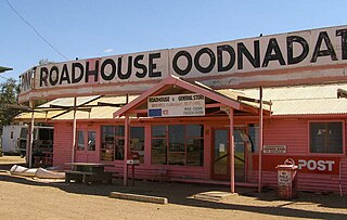
Oodnadatta is a small, remote outback town and locality in the Australian state of South Australia, located 1043 kilometres north-north-west of the state capital of Adelaide by road or 873 km (542 mi) direct, at an altitude of 112 metres. The unsealed Oodnadatta Track, an outback road popular with tourists, runs through the town.
The Fremantle line is a suburban railway and service in Western Australia that connects the central business district (CBD) of Perth with Fremantle.

The Australind is a currently suspended rural passenger train service in Western Australia operated by Transwa on the South Western Railway between Perth and Bunbury.
Benger is a locality just north of Brunswick Junction in the South West of Western Australia.

Brunswick Junction is a town in the South West of Western Australia, situated along the South Western Highway between Harvey and Bunbury. It had a population of 772 people at the 2016 census, down from 797 at the 2006 census.

North Dandalup is a small town in the Peel region of Western Australia along the South Western Highway between Serpentine and Pinjarra. Its local government area is the Shire of Murray. At the 2011 census, North Dandalup had a population of 346.

Doodlakine is a town 220 km (140 mi) east of Perth, Western Australia. It is within the Shire of Kellerberrin along the Great Eastern Highway. The town has a crossing loop for trains on the Perth-to-Kalgoorlie railway and serves as a stop on the MerredinLink rural train service.
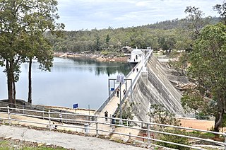
Mundaring Weir is a concrete gravity dam located 39 kilometres (24 mi) from Perth, Western Australia in the Darling Scarp. The dam and reservoir form the boundary between the suburbs of Reservoir and Sawyers Valley. The dam impounds the Helena River.

Williams is a town located in the Wheatbelt region of Western Australia, 161 kilometres (100 mi) south-southeast of the state capital, Perth along Albany Highway and 32 kilometres (20 mi) west of Narrogin. The Williams River passes through the town. At the 2016 census, Williams had a population of 411.

The Upper Nepean Scheme is a series of dams and weirs in the catchments of the Cataract, Cordeaux, Avon and Nepean rivers of New South Wales, Australia. The scheme includes four dams and two weirs, and a gravity-fed canal system that feeds into a large storage reservoir to provide water to the Macarthur and Illawarra regions, the Wollondilly Shire, and metropolitan Sydney. The four dams and associated infrastructure are individually listed on the New South Wales State Heritage Register.

The Goldfields Water Supply Scheme is a pipeline and dam project that delivers potable water from Mundaring Weir in Perth to communities in Western Australia's Eastern Goldfields, particularly Coolgardie and Kalgoorlie. The project was commissioned in 1896 and completed in 1903.
Roelands is a town in the South West region of Western Australia on the South Western Highway, between Brunswick Junction and Bunbury. At the 2011 census, Roelands had a population of 620.

The South Western Railway, also known as the South West Main Line, is the main railway route between Perth and Bunbury in Western Australia.
Bilbarin is a small town in the Shire of Corrigin in the Wheatbelt region of Western Australia.

Vasai-Virar is an agglomeration of four previously governed municipal councils: Vasai (Bassein), Virar, Nallasopara and Navghar-Manikpur, as well as a few towns to the east and west of the urban area. It lies in the Konkan division of Maharashtra, India.
The Esperance Branch Railway is a railway from Kalgoorlie to the port of Esperance in Western Australia.
The Lunenburgh River is a perennial river in the South West region of Western Australia.
Mungalup is a rural town and locality of the Shire of Collie in the South West region of Western Australia.

The Brunswick Junction to Narrogin railway line is a partially operational railway line in the South West and Wheatbelt regions of Western Australia, connecting Brunswick Junction via Collie and Bowelling to Narrogin.

