Welshpool, Western Australia

Last updated

Welshpool
Perth,  Western Australia
Welshpool, Western Australia.jpg
Welshpool Road, Welshpool
Welshpool, Western Australia
Coordinates 31°59′38″S115°57′22″E / 31.994°S 115.956°E / -31.994; 115.956
Population16 (SAL 2021) [1]
Established1895
Postcode(s) 6106
Area8.3 km2 (3.2 sq mi)
Location11 km (7 mi) from the Perth CBD
LGA(s)
State electorate(s) Belmont, Victoria Park
Federal division(s) Swan
Suburbs around Welshpool:
Carlisle Kewdale Kewdale
East Victoria Park Welshpool Wattle Grove
St James
Bentley
Queens Park
East Cannington
Beckenham
Kenwick

Welshpool is an inner southeastern suburb of Perth, Western Australia, located mostly within the City of Canning and partially within the Town of Victoria Park.

Contents

The area is one of the main industrial areas of Perth, along with Kewdale, Kwinana Beach, Henderson, Malaga, O'Connor, Canning Vale and Osborne Park. [2]

It is the location of the Welshpool railway station.

Welshpool is visually known for its 3 complexes of silo towers. These house storage of feed products for the poultry and agricultural industries.

Welshpool is a traditional industrial suburb partly to the fact of its proximity to Perth Airport and short distance to the Perth CBD.

Welshpool is named after the town of Welshpool in Wales.

Transport

Welshpool was home to Welshpool railway station; it was located on the Armadale and Thornlie lines.

In the twentieth century the railway station yard was connected to a number of active sidings, including in the second world war to a munitions factory, [3] however by the 2000s all sidings had been removed.

Welshpool Station closed in 2023 due to the modernisation of the railway line and low patronage. Welshpool Station was not connected to bus routes, though routes 282 and 283 are located close by on Welshpool Road. Both these routes run from Elizabeth Quay bus station to Kalamunda bus station. Welshpool Station was closed on November 20th 2023 and was demolished soon after.

Bus

Related Research Articles

<span class="mw-page-title-main">Forrestfield, Western Australia</span> Suburb of Perth, Western Australia

Forrestfield is a suburb of the City of Kalamunda in Western Australia. It lies 15 kilometres to the south-east of Perth at the base of the Darling Scarp and the southern border of Perth Airport.

<span class="mw-page-title-main">Elizabeth Quay bus station</span> Bus station in Perth, Western Australia

Elizabeth Quay bus station, formerly the Esplanade Busport, is a Transperth bus station, located at the southern edge of the Perth CBD in Western Australia, next to the Perth Convention Exhibition Centre and Elizabeth Quay railway station. It has 35 stands and is served by 55 Transperth routes operated by Path Transit, Swan Transit and Transdev WA. It is also served by South West Coach Lines services.

<span class="mw-page-title-main">Stirling railway station, Perth</span> Railway station in Perth, Western Australia

Stirling railway station is a railway station on the Transperth network. It is located on the Joondalup line, nine kilometres from Perth station serving the suburb of Stirling.

<span class="mw-page-title-main">Cannington railway station</span> Railway station in Perth, Western Australia

Cannington is a temporarily closed railway station on the Armadale and Thornlie lines, serving the suburb of Cannington south of Perth, Western Australia. It is located 12.2 kilometres (7.6 mi) from Perth Station, and is part of the Transperth commuter rail network. It temporarily closed on 20 November 2023 as part of the Victoria Park-Canning Level Crossing Removal Project.

<span class="mw-page-title-main">Oats Street railway station</span> Railway station in Perth, Western Australia

Oats Street railway station is a temporarily-closed Transperth suburban railway station in Western Australia, located in the Perth suburbs of Carlisle and East Victoria Park. The station was served by the Armadale and Thornlie lines prior to its closure in November 2023.

<span class="mw-page-title-main">Thornlie railway station</span> Railway station in Perth, Western Australia

Thornlie railway station is a temporarily closed railway station on the Transperth network. It was the terminus of the Thornlie line, a spur of the Armadale Line, seventeen kilometres (11 mi) from Perth Station serving the suburb of Thornlie, Western Australia. Under construction is the Thornlie-Cockburn Link which will link to Cockburn Central railway station along the Mandurah line via two new stations, Nicholson Road railway station and Ranford Road railway station.

<span class="mw-page-title-main">Claremont railway station, Perth</span> Railway station in Perth, Western Australia

Claremont railway station is a railway station on the Transperth network in Western Australia. It is located on the Fremantle and Airport lines, 9.3 kilometres from Perth station serving the suburb of Claremont.

<span class="mw-page-title-main">Kalamunda bus station</span> Bus station in Perth, Western Australia

Kalamunda bus station is a Transperth bus station located next to the Kalamunda Central shopping centre in Kalamunda, Western Australia. It has four stands and is served by eight Transperth routes operated by Path Transit and Swan Transit.

<span class="mw-page-title-main">Warwick railway station, Perth</span> Railway station in Perth, Western Australia

Warwick railway station is a railway station on the Transperth network. It is located on the Joondalup line, 13 kilometres (8.1 mi) from Perth station serving the suburb of Warwick.

<span class="mw-page-title-main">Whitfords railway station</span> Railway station in Perth, Western Australia

Whitfords railway station is a railway station located on the boundary of Padbury and Kingsley, suburbs of Perth, Western Australia. It is on the Joondalup railway line, which is part of the Transperth commuter rail network. It is located in the median of the Mitchell Freeway, and consists of an elevated bus interchange on top of an island platform at ground level. South of Whitfords, trains run every 5 minutes during peak. North of Whitfords, trains run every 10 minutes during peak. Between peak during the day, trains run every 15 minutes. The journey to Perth railway station is 19.8 kilometres (12.3 mi), and takes 19 minutes.

<span class="mw-page-title-main">Ardross, Western Australia</span> Suburb of Perth, Western Australia

Ardross is a suburb of Perth, Western Australia, located within the City of Melville. It was once an area of land acquired by the Scotsman, Sir Alexander Percival Matheson in 1896. In Matheson's subdivision of the adjoining suburb of Applecross, he created "Ardross Street" naming it after either the town of Ardrossan on the Scottish west coast or Ardross Castle, located about 40 kilometres north of Inverness. The suburb derives its name from this street.

<span class="mw-page-title-main">Carlisle, Western Australia</span> Suburb of Perth, Western Australia

Carlisle is a suburb of Perth, Western Australia. Its local government area is the Town of Victoria Park.

<span class="mw-page-title-main">Alexander Heights, Western Australia</span> Suburb of Perth, Western Australia

Alexander Heights is a suburb of Perth, Western Australia within the City of Wanneroo.

<span class="mw-page-title-main">Applecross, Western Australia</span> Suburb of Perth, Western Australia

Applecross is an affluent riverside suburb of Perth, Western Australia, bounded by Canning Highway and the Swan River. It is located within the City of Melville.

<span class="mw-page-title-main">Kewdale, Western Australia</span> Suburb of Perth, Western Australia

Kewdale is a suburb of Perth, Western Australia within the City of Belmont. Kew Street was one of the first roads in this district, hence the naming of the suburb.

East Cannington is a southeastern suburb of Perth, Western Australia. Its local government area is the City of Canning.

<span class="mw-page-title-main">Queens Park, Western Australia</span> Suburb of Perth, Western Australia

Queens Park is a suburb of Perth, Western Australia, located within the City of Canning. Its postcode is 6107.

High Wycombe is a suburb of Perth, Western Australia, within the City of Kalamunda. High Wycombe lies east of the Perth CBD at the base of the Darling Scarp. Formerly part of Maida Vale, the suburb was officially declared on 2 June 1978; its name, which was first used in 1958 by a subdivider, Western Agencies, refers to the town in Buckinghamshire where one of the partners in the firm was born.
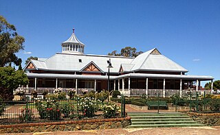
<span class="mw-page-title-main">Wattle Grove, Western Australia</span> Suburb of Perth, Western Australia

Wattle Grove is a suburb of Perth, Western Australia, located within the City of Kalamunda.
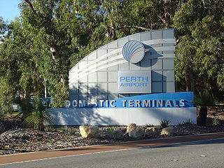
References

  1. Australian Bureau of Statistics (28 June 2022). "Welshpool (WA) (suburb and locality)". Australian Census 2021 QuickStats. Retrieved 28 June 2022.  OOjs UI icon edit-ltr-progressive.svg
  2. Jacka, Raeme (1962), Welshpool : a history of the early settlement and development of a modern industrial area , retrieved 23 February 2021
  3. "Factory that was". The West Australian . Vol. 62, no. 18, 634. Western Australia. 3 April 1946. p. 10. Retrieved 16 March 2024 via National Library of Australia.
  4. "Route 36". Bus Timetable 109 (PDF). Transperth. 25 August 2023 [effective from 20 November 2023].
  5. "Route 51". Bus Timetable 88 (PDF). Transperth. 5 January 2024 [effective from 28 January 2024].
  6. "Route 280". Bus Timetable 110 (PDF). Transperth. 12 January 2024 [effective from 4 February 2024].
  7. "Route 282". Bus Timetable 94 (PDF). Transperth. 10 October 2023 [effective from 20 November 2023].
  8. "Route 283". Bus Timetable 94 (PDF). Transperth. 10 October 2023 [effective from 20 November 2023].
  9. "Route 284". Bus Timetable 89 (PDF). Transperth. 25 August 2022 [effective from 20 November 2022].
  10. "Route 285". Bus Timetable 89 (PDF). Transperth. 25 August 2022 [effective from 20 November 2022].

"History of metropolitan suburb names – W". Western Australian Land Information Authority. Archived from the original on 16 March 2022. Retrieved 4 August 2008.