Wilson, Western Australia

Last updated

Wilson
Perth,  Western Australia
Castledare1.JPG
Wilson, Western Australia
Coordinates 32°01′13″S115°54′43″E / 32.0203795°S 115.9118299°E / -32.0203795; 115.9118299 (Wilson)
Population6,608 (SAL 2021) [1]
Postcode(s) 6107
LGA(s) City of Canning
State electorate(s) Victoria Park, Cannington
Federal division(s) Tangney
Suburbs around Wilson:
Bentley Bentley Cannington
Waterford Wilson Cannington
Riverton Ferndale Ferndale

Wilson is a suburb of Perth, Western Australia, located within the City of Canning on the north bank of the Canning River. It is a fairly old suburb with parks and close proximity to prominent shopping centres in South Perth. It is favoured by Curtin University students, the reason being its convenient access to the university.[ citation needed ] Bus numbers 72 and 75 travel through this suburb. The suburb contains Castledare, Kent Street Weir, Canning River and Lo Quay River Cafe. Wilson is located quite closely to various park, some of those being Cetenary Park, Thomas Moore Park, and Alderley Park.

Contents

Transport

Bus

Related Research Articles

Dianella is a suburb of Perth, Western Australia. It is within the local government area of the City of Stirling.

<span class="mw-page-title-main">Kensington, Western Australia</span> Suburb of Perth, Western Australia

Kensington is a residential suburb 3 km from Perth's central business district. Kensington is located within the City of South Perth and Town of Victoria Park local government areas.

<span class="mw-page-title-main">Waterford, Western Australia</span> Suburb of Perth, Western Australia

Waterford is a small riverside suburb of Perth, the state capital of Western Australia. Its local government area is the City of South Perth.

<span class="mw-page-title-main">Riverton, Western Australia</span> Suburb of Perth, Western Australia

Riverton is a southeastern suburb of Perth, the capital city of Western Australia. Its local government area is the City of Canning.

<span class="mw-page-title-main">Ardross, Western Australia</span> Suburb of Perth, Western Australia

Ardross is a suburb of Perth, Western Australia, located within the City of Melville. It was once an area of land acquired by the Scotsman, Sir Alexander Percival Matheson in 1896. In Matheson's subdivision of the adjoining suburb of Applecross, he created "Ardross Street" naming it after either the town of Ardrossan on the Scottish west coast or Ardross Castle, located about 40 kilometres north of Inverness. The suburb derives its name from this street.

<span class="mw-page-title-main">Parkwood, Western Australia</span> Suburb of Perth, Western Australia

Parkwood is a southeastern suburb of Perth, the capital city of Western Australia. Its local government area is the City of Canning.

<span class="mw-page-title-main">Welshpool, Western Australia</span> Suburb of Perth, Western Australia

Welshpool is an inner southeastern suburb of Perth, Western Australia, located mostly within the City of Canning and partially within the Town of Victoria Park.

<span class="mw-page-title-main">Alfred Cove, Western Australia</span> Suburb of Perth, Western Australia

Alfred Cove is a southern suburb of Perth, Western Australia. Its local government area is the City of Melville.

<span class="mw-page-title-main">Applecross, Western Australia</span> Suburb of Perth, Western Australia

Applecross is an affluent riverside suburb of Perth, Western Australia, bounded by Canning Highway and the Swan River. It is located within the City of Melville.
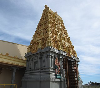
<span class="mw-page-title-main">Canning Vale, Western Australia</span> Suburb of Perth, Western Australia

Canning Vale is a southern suburb of Perth, 22 km (13.7 mi) from the central business district. Its local government areas are the City of Canning and the City of Gosnells.

<span class="mw-page-title-main">Bentley, Western Australia</span> Suburb of Perth, Western Australia

Bentley is a southern suburb of Perth, the capital city of Western Australia, 8 kilometres (5.0 mi) southeast of Perth's central business district. Its local government areas are the City of Canning and the Town of Victoria Park. Bentley is home to the main campus of Curtin University and Technology Park.

<span class="mw-page-title-main">Cannington, Western Australia</span> Suburb of Perth, Western Australia

Cannington is a southern suburb of Perth, Western Australia. Its local government area is the City of Canning.

East Cannington is a southeastern suburb of Perth, Western Australia. Its local government area is the City of Canning.

<span class="mw-page-title-main">Queens Park, Western Australia</span> Suburb of Perth, Western Australia

Queens Park is a suburb of Perth, Western Australia, located within the City of Canning. Its postcode is 6107.

Rossmoyne is a suburb of Perth, Western Australia, within the City of Canning. Rossmoyne is located 14 kilometres (8.7 mi) south of central Perth, and is bounded by Leach Highway to the south, the Bull Creek to the west, the Canning River to the north, and Shelley to the east.

Shelley is a suburb of Perth, Western Australia, located within the City of Canning.

St James is a suburb shared between the Town of Victoria Park and the City of Canning in the Perth metropolitan area.

<span class="mw-page-title-main">Willetton, Western Australia</span> Suburb of Perth, Western Australia

Willetton is a large southern suburb of Perth, Western Australia. Its local government area is the City of Canning.

<span class="mw-page-title-main">Belmont, Western Australia</span> Suburb of Perth, Western Australia

Belmont is a suburb of Perth, the capital city of Western Australia, and is located 7 kilometres (4 mi) east of Perth's central business district (CBD) on the southern bank of the Swan River. Its local government area is the City of Belmont.

<span class="mw-page-title-main">Nedlands, Western Australia</span> Suburb of Perth, Western Australia

Nedlands is a western suburb of Perth, the capital city of Western Australia. It is a part of the local government areas of the City of Nedlands and the City of Perth. It is about 7 kilometres (4 mi) from the Perth CBD via either Thomas Street or Mounts Bay Road.

References

  1. Australian Bureau of Statistics (28 June 2022). "Wilson (suburb and locality)". Australian Census 2021 QuickStats. Retrieved 28 June 2022.  OOjs UI icon edit-ltr-progressive.svg
  2. "Route 72". Bus Timetable 15 (PDF). Transperth. 25 August 2023 [effective from 20 November 2023].
  3. "Route 75". Bus Timetable 15 (PDF). Transperth. 25 August 2023 [effective from 20 November 2023].
  4. "Route 100". Bus Timetable 20 (PDF). Transperth. 25 August 2023 [effective from 20 November 2023].
  5. "Route 177". Bus Timetable 9 (PDF). Transperth. 5 September 2023 [effective from 20 November 2023].
  6. "Route 178". Bus Timetable 9 (PDF). Transperth. 5 September 2023 [effective from 20 November 2023].
  7. "Route 179". Bus Timetable 13 (PDF). Transperth. 24 August 2023 [effective from 20 November 2023].
  8. "Route 509". Bus Timetable 13 (PDF). Transperth. 24 August 2023 [effective from 20 November 2023].
  9. "Route 998". CircleRoute Timetable 200 (PDF). Transperth. 29 August 2023 [effective from 20 November 2023].
  10. "Route 999". CircleRoute Timetable 200 (PDF). Transperth. 29 August 2023 [effective from 20 November 2023].

Commons-logo.svg Media related to Wilson, Western Australia at Wikimedia Commons