Orrong Road

Last updated

Orrong Road

Orrong Road
General information
TypeRoad
Length8.1 km (5.0 mi) [1]
Opened1937 [2]
Route number(s) Australian state route 8.svg State Route 8 (entire length)
Major junctions
North-West end
 
South-East end
Location(s)
Major suburbs Lathlain, Rivervale, Carlisle, Kewdale

Orrong Road is a major arterial road servicing the metropolitan area of Perth, Western Australia as well as the south-eastern continuation of the Graham Farmer Freeway. It is a dual carriageway for its entire length, with multiple sets of traffic lights.

Contents

In addition to servicing the southeastern suburbs of Perth, the road provides a vital connection from the Perth CBD to Perth Airport, the Kewdale Freight Terminal and the Darling Scarp. It is designated H27 (Rivervale–Wattle Grove Link) in Main Roads' internal designation along with Welshpool Road East west of Tonkin Highway. [3]

Route description

The entire length of Orrong Road is a four lane dual-carriageway, similar to other major roads in the area such as Albany Highway, Welshpool Road and Abernethy Road. Unlike those roads however, the carriageways of Orrong Road are separated by a wide tree-lined central median, giving the road more of a boulevard appearance.

The western terminus of Orrong Road is located just to the southeast of the parclo interchange between Graham Farmer Freeway and Great Eastern Highway where the road transitions from a freeway to an at-grade dual carriageway. The road continues in a south-easterly direction forming the boundary between the Town of Victoria Park's Lathlain and the City of Belmont's Rivervale. The first traffic light intersection is encountered at Francisco Street. At Roberts Road the southern suburb boundary changes to Carlisle, with the northern suburb swapping to Kewdale just south of the signalised intersection with Archer Street (at the Sydenham Street cul-de-sac).

The next signalised intersection, with Wright Street, connects Orrong Road to Belmont Forum. The final set of lights prior to Leach Highway is found at the intersection with Oats Street. At Briggs Street the southern suburb boundary changes to the City of Canning's Welshpool with the road now marking the northern limit of the Welshpool industrial area

The road then intersects with Leach Highway at a diamond interchange with Leach Highway free-flowing over Orrong Road, after which the northern side also transitions from a residential to an industrial area. The next signalised intersection with Division and Bell Street sees the road fully enter Welshpool. Two more sets of lights are encountered at Pilbara Street and Kewdale Road. After Kewdale Road the road curves to the east and runs parallel with Welshpool Road 300–400 metres (980–1,310 ft) to the south. The two roads eventually connect to each other via a signalised intersection with McDowell Street as a proxy for Welshpool Road.

Orrong Road's eastern terminus is at the diamond interchange with Roe Highway. As with Leach Highway, Roe Highway is also free-flowing over Orrong Road, which continues as Welshpool Road East from this point.

History

Orrong Road was gazetted in 1937 from sections of roads at the time that were originally known as Hawkstone Street, Prospect Road, Burswood Avenue and Wickalls Avenue. The road was named after Orrong Road in Melbourne, itself an important road in Melbourne's inner south eastern suburbs. [4]

Since gazetting Orrong Road has undergone major changes. Originally a two lane road with additional lanes at traffic signals, it was widened significantly in the 1980s and early 1990s in preparation for the construction of Graham Farmer Freeway. This required the demolition of several properties. At this time, trees were planted in the median. [5] In 1997 the intersection with Great Eastern Highway was converted to an interchange in preparation for the connection to Graham Farmer Freeway. [6] In 2002, before Roe Highway's extension, Orrong Road terminated at McDowell Street in the form of a T-junction, where vehicles could then travel south to Welshpool Road. Orrong Road was extended to meet Roe Highway in the form of a diamond interchange when Roe Highway was extended beyond Welshpool Road in 2003 and now continues as Welshpool Road East. In 2007 the Leach Highway intersection was converted to an interchange. [7]

Future

In 2011 a study was announced by the then Transport Minister, Troy Buswell, to look into building an Airport expressway. This would involve upgrading Orrong Road, along with Leach Highway from Orrong Road to the Airport, to a 100km/h freeway. [8] This seems to have been dropped at the time, in favour of the Airport Line.

In late May 2019 a new planning study was announced by Mainroads WA. The concept planned for Orrong Road to be substantially upgraded in the future to a four lane expressway, running in a trench structure along the current median from Graham Farmer Freeway to President Street, before rising onto a viaduct over Leach Highway and Division and Bell Streets. Service roads along each side would provide access to properties on Orrong Road. [9] [10] Overall support for the concept is high, with 87 percent of respondents supporting the concept in community consultation. [11] The Town of Victoria Park, (which includes part of the Orrong Road Road reserve north of Wright Street, and all of it from Wright Street to Kew Street) has given support for the concept, noting the high level of community support. However they have noted some opposition to the removal of the existing trees in the median. [8]

Junctions

LGALocation [1] kmmiDestinationsNotes
Victoria ParkBelmont boundary BurswoodLathlainRivervale tripoint00.0Australian national highway 94.svgAustralian national route 1.svgWestern Australia MR-SM-11.svg Great Eastern Highway (National Highway 94 / National Route 1)  Midland, Fremantle , Perth Airport Northern terminus of Orrong Road starts just south of the interchange; Modified diamond interchange: additional northwest bound looped entrance ramp. Orrong Road continues as Graham Farmer Freeway northbound.
Lathlain–Rivervale boundary0.60.37Francisco Street northeast  Belmont
Francisco Place southwest
Traffic light intersection
Lathlain–Rivervale–Carlisle tripoint1.20.75Roberts Road  Victoria Park
Rivervale–Carlisle boundary1.50.93Alexander Road
1.71.1Archer Street  Victoria Park Traffic light intersection
Carlisle–Kewdale boundary2.11.3Wright Street northeast  Cloverdale
Galaxy Way southwest
Traffic light intersection with full movements between Orrong Road and Wright Street only.
Galaxy Way unsignalised, northbound left in only
2.71.7 Oats Street   East Victoria Park, Bentley, Cloverdale Traffic light intersection
Victoria Park–Belmont–Canning tripointCarlisle–Kewdale–Welshpool tripoint3.22.0Briggs Street
Belmont–Canning boundaryKewdale–Welshpool boundary3.82.4Australian state route 7.svgWestern Australia MR-SM-11.svg Leach Highway (State Route 7)  Fremantle, Wilson , Perth Airport Diamond interchange (Leach Highway free flowing)
4.12.5Bell Street northeast
Division Street southwest
Traffic light intersection
CanningWelshpool4.72.9Pilbara StreetTraffic light intersection
5.13.2Western Australia MR-SM-11.svg Kewdale Road  Kewdale , Perth Airport Traffic light intersection
6.13.8Kurnall Road
74.3McDowell Street  East Victoria Park, Beckenham Traffic light intersection, main connection to Welshpool Road.
Welshpool–East Cannington boundary7.74.8Felspar Street  East Victoria Park, East Cannington, Beckenham
8.15.0Australian state route 3.svg Roe Highway (State Route 3)  Perth, Rockingham, Midland Southern terminus of Orrong Road, continues as Welshpool Road East southeast bound; Diamond interchange (Roe Highway free-flowing).
1.000 mi = 1.609 km; 1.000 km = 0.621 mi

Related Research Articles

<span class="mw-page-title-main">Division of Swan</span> Australian federal electoral division

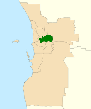
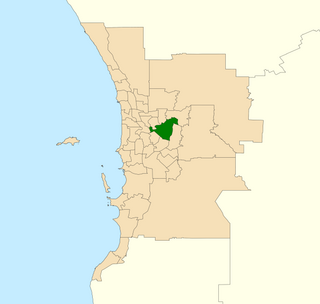
The Division of Swan is an Australian electoral division located in Western Australia.

<span class="mw-page-title-main">Great Eastern Highway</span> Highway in Western Australia

Great Eastern Highway is a 590-kilometre-long (370 mi) road that links the Western Australian capital of Perth with the city of Kalgoorlie. A key route for road vehicles accessing the eastern Wheatbelt and the Goldfields, it is the western portion of the main road link between Perth and the eastern states of Australia. The highway forms the majority of National Highway 94, although the alignment through the Perth suburbs of Guildford and Midland, and the eastern section between Coolgardie and Kalgoorlie are not included. Various segments form parts of other road routes, including National Route 1, Alternative National Route 94, and State Route 51.

The Kwinana Freeway is a 72-kilometre (45 mi) freeway in and beyond the southern suburbs of Perth, Western Australia, linking central Perth with Mandurah to the south. It is the central section of State Route 2, which continues north as Mitchell Freeway to Clarkson, and south as Forrest Highway towards Bunbury. A 4-kilometre (2.5 mi) section between Canning and Leach highways is also part of National Route 1. Along its route are interchanges with several major roads, including Roe Highway and Mandjoogoordap Drive. The northern terminus of the Kwinana Freeway is at the Narrows Bridge, which crosses the Swan River, and the southern terminus is at Pinjarra Road, east of Mandurah.

<span class="mw-page-title-main">Graham Farmer Freeway</span> Freeway in Perth, Western Australia

Graham Farmer Freeway is a 6.4-kilometre (4.0 mi) inner-city freeway in Perth, Western Australia. It links Rivervale and Burswood with West Perth and Leederville, providing an east-west bypass of Perth's central business district.

The Mitchell Freeway is a 41.5-kilometre-long (25.8 mi) freeway in the northern suburbs of Perth, Western Australia, linking central Perth with the city of Joondalup. It is the northern section of State Route 2, which continues south as Kwinana Freeway and Forrest Highway. Along its length are interchanges with several major roads, including the Graham Farmer Freeway and Reid Highway. The southern terminus of the Mitchell Freeway is at the Narrows Bridge, which crosses the Swan River, and the northern terminus is at Romeo Road in Alkimos.

<span class="mw-page-title-main">Kewdale, Western Australia</span> Suburb of Perth, Western Australia

Kewdale is a suburb of Perth, Western Australia within the City of Belmont. Kew Street was one of the first roads in this district, hence the naming of the suburb.

<span class="mw-page-title-main">Roe Highway</span> Highway in Perth, Western Australia

Roe Highway is a 35-kilometre-long (22 mi) limited-access highway and partial freeway in Perth, Western Australia, linking Kewdale with the city's north-eastern and south-western suburbs. The northern terminus is at Reid Highway and Great Northern Highway in Middle Swan, and the southern terminus is with Murdoch Drive at the Kwinana Freeway interchange in Bibra Lake. Roe Highway, in addition to Reid Highway, form State Route 3, a partial ring road around the outer suburbs of the Perth metropolitan area. Roe Highway also forms part of National Highway 94 from Great Eastern Highway Bypass to Great Eastern Highway, and National Highway 95 from Great Eastern Highway to Great Northern Highway.

<span class="mw-page-title-main">Wanneroo Road</span> Road in Perth, Western Australia

Wanneroo Road is a 44-kilometre (27 mi) arterial highway in the northern suburbs of Perth, Western Australia linking Joondanna and Yokine in the south with Wanneroo and Yanchep in the north. As part of State Route 60, it begins from Charles Street in the inner city and becomes Indian Ocean Drive up to Dongara.

<span class="mw-page-title-main">Reid Highway</span> Highway in Perth, Western Australia

Reid Highway is a 23-kilometre (14 mi) east-west highway and partial freeway in the northern suburbs of Perth, Western Australia, linking North Beach with Middle Swan. As part of State Route 3, it forms half of Perth's outer ring road along with Roe Highway, which it joins onto at its eastern terminus.

Tonkin Highway is an 81-kilometre-long (50 mi) north–south highway and partial freeway in Perth, Western Australia, linking Perth Airport and Kewdale with the city's north-eastern and south-eastern suburbs. As of April 2020, the northern terminus is at the interchange with Brand Highway and Great Northern Highway in Muchea, and the southern terminus is at Thomas Road in Oakford. It forms the entire length of State Route 4, and connects to several major roads. Besides Brand Highway and Great Northern Highway, it also connects to Reid Highway, Great Eastern Highway, Leach Highway, Roe Highway, and Albany Highway.

<span class="mw-page-title-main">Leach Highway</span> Highway in Perth, Western Australia

Leach Highway is a 23-kilometre (14 mi) east-west arterial highway in the southern suburbs of Perth, Western Australia, primarily linking Kewdale and Perth Airport with the city of Fremantle.

<span class="mw-page-title-main">Wattle Grove, Western Australia</span> Suburb of Perth, Western Australia

Wattle Grove is a suburb of Perth, Western Australia, located within the City of Kalamunda.

<span class="mw-page-title-main">Electoral district of Belmont</span> State electoral district of Western Australia

Belmont is an electoral district of the Legislative Assembly in the Australian state of Western Australia. Belmont is named for the inner eastern Perth suburb of Belmont, which falls within its borders.

<span class="mw-page-title-main">Welshpool Road</span> Road in Perth, Western Australia

Welshpool Road is a major arterial road running through the metropolitan area of Perth, Western Australia. Although the road is now split in two, having had its western and eastern sections disconnected due to the extension of Roe Highway, it remains Welshpool's second most important road, and the highest quality access road for the Darling Scarp.

Armadale Road is a major road in the south and south east of the Perth Metropolitan Area. It serves three purposes: firstly, providing a main route from Armadale to Fremantle; secondly, connecting Armadale to the Kwinana Freeway; and thirdly, since 2005, connecting it to the Tonkin Highway which ferries traffic to the eastern suburbs, Perth Airport and the Forrestfield and Kewdale industrial areas.

Abernethy Road is a 14.7-kilometre (9.1 mi) long minor arterial road linking Belmont with the Great Eastern Highway Bypass in Hazelmere, a suburb of Perth, Western Australia.

<span class="mw-page-title-main">Gateway WA</span> Road construction project in Perth, Western Australia

Gateway WA, formally called the Gateway WA Perth Airport and Freight Access Project, was a $1 billion project that upgraded the road network around Perth Airport.

The Fremantle Eastern Bypass was a proposed bypass of Fremantle, Western Australia, which would have linked Stirling Highway with Roe Highway. A highway link from Roe Highway to Fremantle Port was proposed in the Metropolitan Region Scheme since the 1950s. A reservation for the bypass was included in the scheme in 1973. It was deleted at the request of the state government's Minister for Planning in 1992, reinstated in 1994 following a change of government, and once more deleted in 2004 after another change of government in 2001.

<span class="mw-page-title-main">Beeliar Drive</span> Road in Perth, Western Australia

Beeliar Drive is a major arterial road in the southwestern part of the Perth Metropolitan Area. It provides an important and unbroken east-west link between Kwinana Freeway and Stock Road providing access to residential developments in Beeliar, Yangebup and Lake Coogee in the west to commercial and industrial development in Cockburn Central, Jandakot and Success in the east. It is one of Perth's more recent arterial road constructions with development of the road occurring between the early 1990s and early 2020s.

References

  1. 1 2 Google (9 November 2019). "Orrong Road" (Map). Google Maps . Google. Retrieved 9 November 2019.
  2. "CITY OF BELMONT - List of Names of Streets/Roads, Suburbs, Parks, Perth Airport Roads and Schools" (PDF). Archived from the original (PDF) on 19 April 2020. Retrieved 9 November 2019.
  3. Main Roads Western Australia (28 February 2011). "Metropolitan Network" (Map). Intergrated Service Arrangement. 1:500,000. Government of Western Australia. Archived from the original (PDF) on 3 August 2013. Retrieved 9 November 2019.
  4. "CITY OF BELMONT - List of Names of Streets/Roads, Suburbs, Parks, Perth Airport Roads and Schools" (PDF). Archived from the original (PDF) on 19 April 2020. Retrieved 9 November 2019..
  5. "Landgate map viewer plus". 6 February 1995. Retrieved 24 October 2021.
  6. "Great Eastern Highway set for facelift". 10 February 1996. Archived from the original on 24 October 2021. Retrieved 24 October 2021.
  7. MacTeirnan, Alannah (4 June 2007). "Multi-million dollar interchange dramatically cuts crashes in Welshpool". Archived from the original on 24 October 2021. Retrieved 24 October 2021.
  8. 1 2 "RAC hails 'visionary' airport expressway plan". WA Today. 16 June 2011. Retrieved 24 October 2021.
  9. "Main Roads WA touts underground expressway concept for Orrong Road". The West Australian. Retrieved 24 October 2021.
  10. "Orrong Road Planning Study Overview - May 2019" (PDF). Retrieved 24 October 2021.
  11. "Orrong Road Community Results Snapshot" (PDF). Retrieved 24 October 2021.