Wattle Grove, Western Australia

Last updated

Wattle Grove
Perth,  Western Australia
Wattle Grove.jpg
Crystal Brook Road, Wattle Grove
Wattle Grove, Western Australia
Coordinates 32°00′29″S116°00′50″E / 32.008°S 116.014°E / -32.008; 116.014
Population6,547 (SAL 2021) [1]
Postcode(s) 6107
Location13 km (8 mi) E of Perth, Western Australia
LGA(s) City of Kalamunda
State electorate(s)
Federal division(s) Hasluck
Suburbs around Wattle Grove:
East Cannington Welshpool Perth Airport
Beckenham Wattle Grove Forrestfield
Orange Grove Kenwick Lesmurdie

Wattle Grove is a suburb of Perth, Western Australia, located within the City of Kalamunda.

Contents

Description

Wattle Grove is approximately 2/3 semi-rural, and 1/3 suburban development. It contains some of Hartfield Park, and extends from Crystal Brook Road to Roe Highway. Major transport routes through the suburb are Welshpool Road, Hale Road, Tonkin Highway and Roe Highway.

Public transport

Bus routes are:

The nearest train stations are:

Facilities

Playgrounds are located throughout the new subdivisions in the suburb, as well as walking and bike paths leading to newly created artificial lakes.[ timeframe? ]

Wattle Grove is served by Wattle Grove Primary School, and a Community TAFE Centre in Lewis Road and the Bible College of Western Australia (private). [2] The primary school built on the area bordered by St John Road, Tomah Road, and Acastus Road opened to students in 2011. The previous primary school on Welshpool Road was mothballed with no alternative usage envisioned.

Hartfield Recreation Centre, located nearby, provides gymnasium facilities [3] as well as opportunities for playing AFL football [4] , rugby league, soccer, baseball, cricket and tennis. Hartfield Park also contains the Darling Range Horse and Pony Club, [5] the Hartfield Country Club (golf course), [6] boy scouts, and car club rooms.

Wattle Grove is well connected to other regions of Perth due to its proximity to the Roe Highway and Tonkin Highway. The most direct route to the Perth central business district is via Welshpool and Shepperton Roads (12 km all in 60 km/h zones), however alternative routes are available via Orrong Road / Graham Farmer Freeway (14 km in 70 & 80 km/h zones), Tonkin Highway / Great Eastern Highway (18 km in 100 & 60 km/h zones), and Roe Highway / Kwinana Freeway (23 km all in 100 km/h zone and the only route without traffic lights).

Wattle Grove has one major retail facility within its boundaries, containing Aldi, 7-Eleven and various other stores e.g. a bakery, a sushi shop and a gym. It has two vets, a motel, a number of nurseries, landscape suppliers, agistment paddocks, boarding kennels and a bird, fish and reptile shop. [7] [8] [9] [10] [11] [12]

The nearest police station is at Forrestfield, and public hospitals are available at Bentley and Kalamunda. [13] [14]

History

Prior to European settlement the Beeloo Whadjuk people occupied much of Wattle Grove. In 1827 the colonial botanist Charles Fraser and Captain James Stirling explored the region to evaluate its suitability for farming. Initially the area was used for forestry and orchards; fruit growing continues to be one of the major industries in Wattle Grove, Bickley and Orange Grove today. This suburb name may have come from a property that was in the area around 1920, or the name may have come about in the early 1900s from wattle trees that lined Welshpool Road; the district was described by the European settlers as "where the groves of wattle are". [15] Much of Wattle Grove has developed into other agricultural uses such as poultry farms, equestrian studs, agistment paddocks, horticultural nurseries, pet kennels, hobby farms and cattle breeders. 20 residents of Wattle Grove were killed in action during World War One (1914–1918), 5 of whom were from the one family. [16]

Notable people

Recent events

"Keep Wattle Grove rural" protest sign Images of Wattle Grove 03.JPG
"Keep Wattle Grove rural" protest sign

After a concerted campaign was lost during the 1980s by the Save our Foothills action group a quarter of the suburb bounded by Welshpool Road, Tonkin Highway and Roe Highway has been rezoned as "urban development" by what was then the Shire of Kalamunda and is known as "cell 9" in the Kalamunda Shire Plans. [17] [18] This area of Wattle Grove is now a hive of activity as land is subdivided and houses built. The price of land in cell 9 has subsequently risen exponentially since the first subdivision in 1999. [19]

Related Research Articles

<span class="mw-page-title-main">Town of Victoria Park</span> Local government area in Western Australia

The Town of Victoria Park is a local government area of Western Australia. It covers an area of 17.62 km² in metropolitan Perth, the capital of Western Australia. It had a population of approximately 35,000 as at the 2016 Census.

<span class="mw-page-title-main">Forrestfield, Western Australia</span> Suburb of Perth, Western Australia

Forrestfield is a suburb of the City of Kalamunda in Western Australia. It lies 15 kilometres to the south-east of Perth at the base of the Darling Scarp and the southern border of Perth Airport.

<span class="mw-page-title-main">Division of Swan</span> Australian federal electoral division

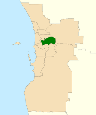
The Division of Swan is an Australian electoral division located in Western Australia.

<span class="mw-page-title-main">Armadale line</span> Suburban rail line in Perth, Western Australia

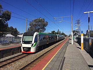
The Armadale line is a suburban railway service in Perth, Western Australia, operated by the Public Transport Authority as part of the Transperth system. The Armadale line is 30.4 kilometres (18.9 mi) long, and starts at Perth station, heading south-east of there to serve Perth's south-eastern suburbs, terminating at Armadale station.

<span class="mw-page-title-main">Oats Street railway station</span> Railway station in Perth, Western Australia

Oats Street railway station is a temporarily-closed Transperth suburban railway station in Western Australia, located in the Perth suburbs of Carlisle and East Victoria Park. The station was served by the Armadale and Thornlie lines prior to its closure in November 2023.

<span class="mw-page-title-main">Welshpool, Western Australia</span> Suburb of Perth, Western Australia

Welshpool is an inner southeastern suburb of Perth, Western Australia, located mostly within the City of Canning and partially within the Town of Victoria Park.

<span class="mw-page-title-main">Cannington, Western Australia</span> Suburb of Perth, Western Australia

Cannington is a southern suburb of Perth, Western Australia. Its local government area is the City of Canning.

East Cannington is a southeastern suburb of Perth, Western Australia. Its local government area is the City of Canning.

<span class="mw-page-title-main">Queens Park, Western Australia</span> Suburb of Perth, Western Australia

Queens Park is a suburb of Perth, Western Australia, located within the City of Canning. Its postcode is 6107.

<span class="mw-page-title-main">Willetton, Western Australia</span> Suburb of Perth, Western Australia

Willetton is a large southern suburb of Perth, Western Australia. Its local government area is the City of Canning.

<span class="mw-page-title-main">Roe Highway</span> Highway in Perth, Western Australia

Roe Highway is a 35-kilometre-long (22 mi) limited-access highway and partial freeway in Perth, Western Australia, linking Kewdale with the city's north-eastern and south-western suburbs. The northern terminus is at Reid Highway and Great Northern Highway in Middle Swan, and the southern terminus is with Murdoch Drive at the Kwinana Freeway interchange in Bibra Lake. Roe Highway, in addition to Reid Highway, form State Route 3, a partial ring road around the outer suburbs of the Perth metropolitan area. Roe Highway also forms part of National Highway 94 from Great Eastern Highway Bypass to Great Eastern Highway, and National Highway 95 from Great Eastern Highway to Great Northern Highway.

<span class="mw-page-title-main">Tonkin Highway</span> Highway in Perth, Western Australia

Tonkin Highway is an 81-kilometre-long (50 mi) north–south highway and partial freeway in Perth, Western Australia, linking Perth Airport and Kewdale with the city's north-eastern and south-eastern suburbs. As of April 2020, the northern terminus is at the interchange with Brand Highway and Great Northern Highway in Muchea, and the southern terminus is at Thomas Road in Oakford. It forms the entire length of State Route 4, and connects to several major roads. Besides Brand Highway and Great Northern Highway, it also connects to Reid Highway, Great Eastern Highway, Leach Highway, Roe Highway, and Albany Highway.

<span class="mw-page-title-main">Leach Highway</span> Highway in Perth, Western Australia

Leach Highway is a 23-kilometre (14 mi) east-west arterial highway in the southern suburbs of Perth, Western Australia, primarily linking Kewdale and Perth Airport with the city of Fremantle.

High Wycombe is a suburb of Perth, Western Australia, within the City of Kalamunda. High Wycombe lies east of the Perth CBD at the base of the Darling Scarp. Formerly part of Maida Vale, the suburb was officially declared on 2 June 1978; its name, which was first used in 1958 by a subdivider, Western Agencies, refers to the town in Buckinghamshire where one of the partners in the firm was born.

<span class="mw-page-title-main">City of Kalamunda</span> Local government area in Western Australia

The City of Kalamunda is a local government area in the eastern metropolitan region of the Western Australian capital city of Perth about 25 kilometres (16 mi) east of Perth's central business district. The area covers 324 square kilometres (125 sq mi), much of which is state forest rising into the Darling Scarp to the east. As of 2021, the city had a population of 58,762.

<span class="mw-page-title-main">Welshpool Road</span> Road in Perth, Western Australia

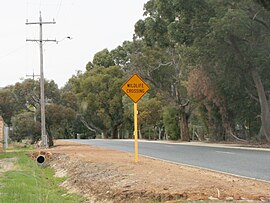
Welshpool Road is a major arterial road running through the metropolitan area of Perth, Western Australia. Although the road is now split in two, having had its western and eastern sections disconnected due to the extension of Roe Highway, it remains Welshpool's second most important road, and the highest quality access road for the Darling Scarp.

Transport in Perth, Western Australia, is served by various means, among them an extensive highway / freeway network and a substantial system of commuter rail lines and bus routes. Public transport is managed by the Transperth agency.

Abernethy Road is a 14.7-kilometre (9.1 mi) long minor arterial road linking Belmont with the Great Eastern Highway Bypass in Hazelmere, a suburb of Perth, Western Australia.

Orrong Road is a major arterial road servicing the metropolitan area of Perth, Western Australia as well as the south-eastern continuation of the Graham Farmer Freeway. It is a dual carriageway for its entire length, with multiple sets of traffic lights.

<span class="mw-page-title-main">Victoria Park-Canning Level Crossing Removal Project</span> Railway elevation project in Perth, Western Australia

The Victoria Park-Canning Level Crossing Removal Project is a project by the Government of Western Australia to elevate part of the Armadale line, thereby removing six level crossings and rebuilding five stations to modern standards. The project is a part of the wider Metronet initiative undertaken by the state government. The stations to be rebuilt as part of the project are, from north to south, Carlisle, Oats Street, Queens Park, Cannington, and Beckenham. Welshpool station will be closed due to low patronage and technical constraints. The level crossings to be removed as part of the project are Mint Street, Oats Street, Welshpool Road, Hamilton Street, Wharf Street, and William Street.

References

  1. Australian Bureau of Statistics (28 June 2022). "Wattle Grove (WA) (suburb and locality)". Australian Census 2021 QuickStats. Retrieved 28 June 2022.  OOjs UI icon edit-ltr-progressive.svg
  2. "Bible College of Western Australia". Bcwa.wa.edu.au. Retrieved 18 July 2011.
  3. "Hartfield Park Rec Centre". Kalamunda.wa.gov.au. Retrieved 18 July 2011.
  4. "Forrestfield Football Club Incorporated". TidyHQ. Retrieved 24 November 2023.
  5. Darling Range Horse and Pony Club Archived 8 September 2007 at the Wayback Machine
  6. "Hartfield Country Club". Hartfieldgolf.com.au. Retrieved 18 July 2011.
  7. "Camp Wattle Grove". Camp Wattle Grove. Retrieved 18 July 2011.
  8. "Wattle Grove Motel". Wattle Grove Motel. Retrieved 18 July 2011.
  9. "Grasstrees at Wattle Grove". Grasstrees.com.au. Retrieved 18 July 2011.
  10. "Lovegrove Turf Farm at Wattle Grove". Lovegroveturf.com. Retrieved 18 July 2011.
  11. Soiland HQ at Wattle Grove
  12. "Trees a green at Wattle Grove". Treesagreen.com. Retrieved 18 July 2011.
  13. WA Police
  14. List of hospitals in Western Australia
  15. "History of metropolitan suburb names – W". Western Australian Land Information Authority. Archived from the original on 16 March 2022. Retrieved 13 October 2019.
  16. ANZAC - A grateful state website Archived 13 September 2009 at the Wayback Machine
  17. "Shire of Kalamunda - Structure Plans". www.kalamunda.wa.gov.au. Archived from the original on 30 October 2014.
  18. "Powering ahead on master plans". Perth Now. 23 March 2012. Retrieved 10 May 2016.
  19. "REIWA Suburb profile of Wattle Grove". REIWA.com. Retrieved 3 March 2016.