Lesmurdie, Western Australia

Last updated

Lesmurdie
Perth,  Western Australia
Perth Panorama from Lesmurdie Falls SMC.jpg
Panorama of Perth with the CBD on the horizon, taken from Lesmurdie Falls
Lesmurdie, Western Australia
Coordinates 31°59′38″S116°03′00″E / 31.994°S 116.050°E / -31.994; 116.050
Population8,413 (SAL 2021) [1]
Established1897
Postcode(s) 6076
Location21 km (13 mi) from Perth, Western Australia
LGA(s) City of Kalamunda
State electorate(s) Kalamunda
Federal division(s) Hasluck
Suburbs around Lesmurdie:
Maida Vale Kalamunda Kalamunda
Forrestfield Lesmurdie Walliston
Wattle Grove Wattle Grove Bickley

Lesmurdie is a suburb of Perth, Western Australia, located within the City of Kalamunda. It was established in 1897 by Archibald Sanderson, a politician and journalist, who began buying properties in the area from the Canning Jarrah Timber Company to build up a rural retreat and fruit-growing property. He named it after Lesmurdie Cottage, a shooting box near Dufftown, Scotland that his father had rented. It was officially gazetted on 8 June 1959. [2] [3]

Contents

The main access to the suburb from the Swan Coastal Plain is via Welshpool Road East, which snakes its way up the side of the Darling Scarp from the suburb of Wattle Grove. Lesmurdie can also be accessed from Kalamunda, Walliston, Carmel and Bickley, primarily through Canning Road.

The shopping centres in the area are the Lesmurdie Village on Sanderson Road and the Lesmurdie Road Shopping Centre on the corner of Rooth Road and Lesmurdie Road.

Lesmurdie has three high schools within its boundaries, the government operated Lesmurdie Senior High School as well as the privately operated Mazenod College for boys and St Brigid's College for girls. There are two government primary schools in Lesmurdie, Lesmurdie Primary School [4] and Falls Road Primary School [5] as well as a privately operated primary school at St Brigid's.

Transport

Bus

See also

Related Research Articles

<span class="mw-page-title-main">Kalamunda, Western Australia</span> Suburb of Perth, Western Australia

Kalamunda is a town and eastern suburb of Perth, Western Australia, located in the Darling Scarp at the eastern limits of the Perth metropolitan area.

<span class="mw-page-title-main">Forrestfield, Western Australia</span> Suburb of Perth, Western Australia

Forrestfield is a suburb of the City of Kalamunda in Western Australia. It lies 15 kilometres to the south-east of Perth at the base of the Darling Scarp and the southern border of Perth Airport.

<span class="mw-page-title-main">Morley, Western Australia</span> Suburb of Perth, Western Australia

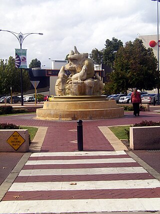
Morley is a suburb of Perth, within the City of Bayswater local government area, situated approximately 10 kilometres (6 mi) northeast of the Perth central business district. It contains the Galleria Shopping Centre, one of Perth's larger shopping centres. Morley bus station is located in the car park of the shopping centre. From the late 1950s, Morley began to develop as a major shopping and commercial centre.

<span class="mw-page-title-main">Como, Western Australia</span> Suburb of Perth, Western Australia

Como is a suburb of Perth, Western Australia. Its local government area is the City of South Perth. The suburb has a population of 12,423. Canning Highway divides the suburb.

<span class="mw-page-title-main">Riverton, Western Australia</span> Suburb of Perth, Western Australia

Riverton is a southeastern suburb of Perth, the capital city of Western Australia. Its local government area is the City of Canning.

<span class="mw-page-title-main">Ardross, Western Australia</span> Suburb of Perth, Western Australia

Ardross is a suburb of Perth, Western Australia, located within the City of Melville. It was once an area of land acquired by the Scotsman, Sir Alexander Percival Matheson in 1896. In Matheson's subdivision of the adjoining suburb of Applecross, he created "Ardross Street" naming it after either the town of Ardrossan on the Scottish west coast or Ardross Castle, located about 40 kilometres north of Inverness. The suburb derives its name from this street.

<span class="mw-page-title-main">Burswood, Western Australia</span> Suburb of Perth, Western Australia

Burswood is an inner southeastern suburb of Perth, Western Australia, located immediately across the Swan River from Perth's central business district (CBD). Its local government area is the Town of Victoria Park. Burswood is the location of the State Tennis Centre, Perth Stadium, Belmont Park Racecourse, and the Crown Perth casino and hotel complex.

<span class="mw-page-title-main">Carlisle, Western Australia</span> Suburb of Perth, Western Australia

Carlisle is a suburb of Perth, Western Australia. Its local government area is the Town of Victoria Park.

<span class="mw-page-title-main">Welshpool, Western Australia</span> Suburb of Perth, Western Australia

Welshpool is an inner southeastern suburb of Perth, Western Australia, located mostly within the City of Canning and partially within the Town of Victoria Park.

<span class="mw-page-title-main">Mount Pleasant, Western Australia</span> Suburb of Perth, Western Australia

Mount Pleasant is a suburb of Perth, Western Australia, located within Wajuk country, and the City of Melville, on the Canning River. It is bounded by Canning Highway to the north, the Canning River to the east, Cranford Avenue, Moolyeen Road and Canning Avenue to the south, and Rogerson Road, Coomoora Road, Henley Road and Ardross Street to the west.

<span class="mw-page-title-main">Kewdale, Western Australia</span> Suburb of Perth, Western Australia

Kewdale is a suburb of Perth, Western Australia within the City of Belmont. Kew Street was one of the first roads in this district, hence the naming of the suburb.

East Cannington is a southeastern suburb of Perth, Western Australia. Its local government area is the City of Canning.

<span class="mw-page-title-main">Queens Park, Western Australia</span> Suburb of Perth, Western Australia

Queens Park is a suburb of Perth, Western Australia, located within the City of Canning. Its postcode is 6107.

Shelley is a suburb of Perth, Western Australia, located within the City of Canning.

<span class="mw-page-title-main">East Victoria Park, Western Australia</span> Suburb of Perth, Western Australia

East Victoria Park is an inner south-eastern suburb of Perth, Western Australia, located within the Town of Victoria Park.

High Wycombe is a suburb of Perth, Western Australia, within the City of Kalamunda. High Wycombe lies east of the Perth CBD at the base of the Darling Scarp. Formerly part of Maida Vale, the suburb was officially declared on 2 June 1978; its name, which was first used in 1958 by a subdivider, Western Agencies, refers to the town in Buckinghamshire where one of the partners in the firm was born.

<span class="mw-page-title-main">Gooseberry Hill, Western Australia</span> Suburb of Perth, Western Australia

Gooseberry Hill is a suburb of Perth, Western Australia, located within the City of Kalamunda. It is the site of Gooseberry Hill National Park.

<span class="mw-page-title-main">Wattle Grove, Western Australia</span> Suburb of Perth, Western Australia

Wattle Grove is a suburb of Perth, Western Australia, located within the City of Kalamunda.

<span class="mw-page-title-main">Perth Airport (suburb)</span> Suburb of Perth, Western Australia

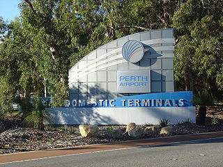
Perth Airport is an eastern suburb of Perth, the capital city of Western Australia. Its local government areas are the City of Belmont, the City of Swan (north) and the City of Kalamunda (east). It is located approximately 12 km east of the central business district. The suburb is the home of Perth Airport, the main international airport of Perth.

<span class="mw-page-title-main">Perth (suburb)</span> Suburb of Perth, Western Australia

Perth is a suburb in the Perth metropolitan region, Western Australia that includes both the central business district of the city, and a suburban area spreading north to the northern side of Hyde Park. It does not include the separate suburbs of Northbridge or Highgate. Perth is split between the City of Perth and the City of Vincent local authorities, and was named after the city of the same name in Scotland.

References

  1. Australian Bureau of Statistics (28 June 2022). "Lesmurdie (suburb and locality)". Australian Census 2021 QuickStats. Retrieved 28 June 2022.  OOjs UI icon edit-ltr-progressive.svg
  2. "History of metropolitan suburb names – L". Western Australian Land Information Authority. Archived from the original on 16 March 2022. Retrieved 12 October 2019.
  3. Grant, Donald (1988). "Sanderson, Archibald (1870–1937)". Australian Dictionary of Biography . Canberra: National Centre of Biography, Australian National University. ISBN   978-0-522-84459-7. ISSN   1833-7538. OCLC   70677943 . Retrieved 20 September 2017.
  4. "Lesmurdie Primary School – Endeavour". Lesmurdie Primary School. Retrieved 9 December 2020.
  5. "Falls Road Primary School – Home". Falls Road Primary School. Retrieved 9 December 2020.
  6. "Route 275". Bus Timetable 109 (PDF). Transperth. 17 July 2024 [effective from 11 August 2024].
  7. "Route 279". Bus Timetable 94 (PDF). Transperth. 4 April 2024 [effective from 21 April 2024].
  8. "Route 281". Bus Timetable 94 (PDF). Transperth. 4 April 2024 [effective from 21 April 2024].
  9. "Route 282". Bus Timetable 94 (PDF). Transperth. 4 April 2024 [effective from 21 April 2024].
  10. "Route 283". Bus Timetable 94 (PDF). Transperth. 4 April 2024 [effective from 21 April 2024].