Eyre Highway is a 1,664-kilometre (1,034 mi) highway linking Western Australia and South Australia via the Nullarbor Plain. Signed as National Highways 1 and A1, it forms part of Highway 1 and the Australian National Highway network linking Perth and Adelaide. It was named after explorer Edward John Eyre, who was the first European to cross the Nullarbor by land, in 1840–1841. Eyre Highway runs from Norseman in Western Australia, past Eucla, to the state border. Continuing to the South Australian town of Ceduna, it crosses the top of the Eyre Peninsula before reaching Port Augusta.

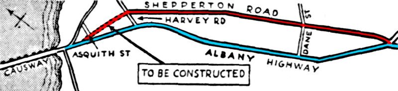
Albany Highway links Western Australia's capital city Perth with its oldest settlement, Albany, on the state's south coast. The 405-kilometre-long (252 mi) highway travels through the southern Wheatbelt and Great Southern regions, and is designated State Route 30 for most of its length. Outside of Perth the highway is predominately a sealed, single carriageway with regular overtaking lanes in some undulating areas. Albany Highway commences at The Causeway, a river crossing that connects to Perth's central business district. The highway heads south-east through Perth's metropolitan region, bypassed in part by Shepperton Road and Kenwick Link, and continues south-eastwards through to Albany. It intersects several major roads in Perth, including the Leach, Tonkin, Brookton, and South Western highways. The rural section of Albany Highway connects to important regional roads at the few towns and roadhouses along the route, including Coalfields Highway at Arthur River, Great Southern Highway at Cranbrook, and Muirs Highway at Mount Barker.

Great Eastern Highway is a 590-kilometre-long (370 mi) road that links the Western Australian capital of Perth with the city of Kalgoorlie. A key route for road vehicles accessing the eastern Wheatbelt and the Goldfields, it is the western portion of the main road link between Perth and the eastern states of Australia. The highway forms the majority of National Highway 94, although the alignment through the Perth suburbs of Guildford and Midland, and the eastern section between Coolgardie and Kalgoorlie are not included. Various segments form parts of other road routes, including National Route 1, Alternative National Route 94, and State Route 51.

Coolgardie–Esperance Highway is a 370-kilometre (230 mi) Western Australian highway between Coolgardie and Esperance. It runs in a north–south direction linking the state's Eastern Goldfields to the coast.

East Victoria Park is an inner south-eastern suburb of Perth, Western Australia, located within the Town of Victoria Park.

South Western Highway is a highway in the South West region of Western Australia connecting Perth's southeast with Walpole. It is a part of the Highway 1 network for most of its length. It is about 406 kilometres (252 mi) long.

Roe Highway is a 35-kilometre-long (22 mi) limited-access highway and partial freeway in Perth, Western Australia, linking Kewdale with the city's north-eastern and south-western suburbs. The northern terminus is at Reid Highway and Great Northern Highway in Middle Swan, and the southern terminus is with Murdoch Drive at the Kwinana Freeway interchange in Bibra Lake. Roe Highway, in addition to Reid Highway, form State Route 3, a partial ring road around the outer suburbs of the Perth metropolitan area. Roe Highway also forms part of National Highway 94 from Great Eastern Highway Bypass to Great Eastern Highway, and National Highway 95 from Great Eastern Highway to Great Northern Highway.

Reid Highway is a 23-kilometre (14 mi) east-west highway and partial freeway in the northern suburbs of Perth, Western Australia, linking North Beach with Middle Swan. As part of State Route 3, it forms half of Perth's outer ring road along with Roe Highway, which it joins onto at its eastern terminus.
Tonkin Highway is an 81-kilometre-long (50 mi) north–south highway and partial freeway in Perth, Western Australia, linking Perth Airport and Kewdale with the city's north-eastern and south-eastern suburbs. As of April 2020, the northern terminus is at the interchange with Brand Highway and Great Northern Highway in Muchea, and the southern terminus is at Thomas Road in Oakford. It forms the entire length of State Route 4, and connects to several major roads. Besides Brand Highway and Great Northern Highway, it also connects to Reid Highway, Great Eastern Highway, Leach Highway, Roe Highway, and Albany Highway.

Leach Highway is a 23-kilometre (14 mi) east-west arterial highway in the southern suburbs of Perth, Western Australia, primarily linking Kewdale and Perth Airport with the city of Fremantle.

Bussell Highway is a generally north–south highway in the South West region of Western Australia. The highway links the city of Bunbury with the town of Augusta and is approximately 140 kilometres (87 mi) in length. The highway is signed State Route 10, except in Busselton where the construction of the Busselton Bypass in 2000 resulted in this stretch being changed to Alternate State Route 10 with the Bypass signed State Route 10.

Victoria Park is an inner suburb of Perth, the capital of the Australian state of Western Australia. It is located on the Swan River south-east of East Perth, and is linked to East Perth and the Perth central business district via The Causeway, which crosses Heirisson Island.

Beaufort Street is a major road in the inner north-eastern suburbs of Perth, Western Australia, connecting the Morley area to the Perth central business district. For most of its length, it is a single-carriageway, two-way road with two lanes in each direction.

Welshpool Road is a major arterial road running through the metropolitan area of Perth, Western Australia. Although the road is now split in two, having had its western and eastern sections disconnected due to the extension of Roe Highway, it remains Welshpool's second most important road, and the highest quality access road for the Darling Scarp.
Transport in Perth, Western Australia, is served by various means, among them an extensive highway/freeway network and a substantial system of commuter rail lines and bus routes. Public transport is managed by the Transperth agency.

Forrest Highway is a 95-kilometre-long (59 mi) highway in Western Australia's Peel and South West regions, extending Perth's Kwinana Freeway from east of Mandurah down to Bunbury. Old Coast Road was the original Mandurah–Bunbury route, dating back to the 1840s. Part of that road, and the Australind Bypass around Australind and Eaton, were subsumed by Forrest Highway. The highway begins at Kwinana Freeway's southern terminus in Ravenswood, continues around the Peel Inlet to Lake Clifton, and heads south to finish at Bunbury's Eelup Roundabout. There are a number of at-grade intersections with minor roads in the shires of Murray, Waroona, and Harvey including Greenlands Road and Old Bunbury Road, both of which connect to South Western Highway near Pinjarra.
Newcastle Inner City Bypass is a freeway in Newcastle and Lake Macquarie, New South Wales, Australia. Originally cobbled together from a collection of arterial roads, it has been slowly upgraded and lengthened in sections over the years to a motorway-standard bypass through the inner western suburbs of Newcastle.

In Western Australia, Highway 1 is a 5,305-kilometre (3,296 mi) long route around the state, from the South Australian border near Eucla to the Northern Territory border near Kununurra. Highway 1 continues around the rest of Australia, joining all mainland state capitals, and connecting major centres in Tasmania. All roads within the Highway 1 system are allocated a road route numbered 1, M1, A1, or B1, depending on the state route numbering system. In Western Australia, most of the highway is designated as National Route 1; however, the sections in the north-east and south-east of the state that are concurrent with the National Highway routes linking Perth to Adelaide and Darwin are designated as National Highway 1.
Abernethy Road is a 14.7-kilometre (9.1 mi) long minor arterial road linking Belmont with the Great Eastern Highway Bypass in Hazelmere, a suburb of Perth, Western Australia.

Drumpellier Drive is a north-south road linking Ellenbrook with Reid Highway in the north-eastern suburbs of Perth, Western Australia. The southern section was opened as Lord Street, and was the main link between Ellenbrook and the rest of Perth until the extension of Tonkin Highway north to Gnangara Road. The road corridor has had several proposals put forward for it, including a highway, a bus rapid transitway and a railway. In 2019, a new alignment for Lord Street south of Gnangara Road opened, and it was renamed to Drumpellier Drive, making the naming consistent with the section of road north of Gnangara Road.